
파일:1842 Manistee Kawtawwabet Missaukee Mickenauk Ogemaw Kanotin Notipeskago Aishcum Unwattin Kaykakee Gladwin Arenac counties Michigan.jpg

미리 보기 크기: 799 × 266 픽셀 다른 해상도: 320 × 107 픽셀 | 640 × 213 픽셀 | 1,537 × 512 픽셀
원본 파일 (1,537 × 512 픽셀, 파일 크기: 861 KB, MIME 종류: image/jpeg)

|
이 그림 파일은 벡터 SVG 형식으로 다시 만들어야 합니다. SVG의 장점에 대해서는 여기(영어)를 참고해 주십시오. 만약 이 그림의 SVG 버전이 이미 존재한다면 이 틀을 {{vector version available|새 파일 이름.svg}}으로 대체해 주십시오.
|


파일 설명
| 설명 |
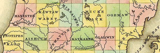
English: Detail of A New Map of Michigan With Its Canals, Roads & Distances by H.S. Tanner, 1842, showing:
|
|||||||||||||||||||
| 날짜 | 1842, ©1841 | |||||||||||||||||||
| 출처 | File:1842 A new map of Michigan with its canals roads distances by H.S. Tanner.jpg | |||||||||||||||||||
| 저자 |
|
|||||||||||||||||||
| 다른 버전 | File:1842 A new map of Michigan with its canals roads distances by H.S. Tanner.jpg | |||||||||||||||||||
라이선스
This media file is in the public domain in the United States. This applies to U.S. works where the copyright has expired, often because its first publication occurred prior to January 1, 1929, and if not then due to lack of notice or renewal. See this page for further explanation.
|
 | |
 |
This image might not be in the public domain outside of the United States; this especially applies in the countries and areas that do not apply the rule of the shorter term for US works, such as Canada, Mainland China (not Hong Kong or Macao), Germany, Mexico, and Switzerland. The creator and year of publication are essential information and must be provided. See Wikipedia:Public domain and Wikipedia:Copyrights for more details.
|
파일 역사
날짜/시간 링크를 클릭하면 해당 시간의 파일을 볼 수 있습니다.
| 날짜/시간 | 섬네일 | 크기 | 사용자 | 설명 | |
|---|---|---|---|---|---|
| 현재 | 2016년 10월 6일 (목) 04:43 | 1,537 × 512 (861 KB) | TimK MSI | {{Information |Description ={{en|1=Detail of A New Map of Michigan With Its Canals, Roads & Distances by H.S. Tanner, 1842 showing: *[[w:Manistee County, Michiga... |
이 파일을 사용하는 문서
다음 문서 1개가 이 파일을 사용하고 있습니다:
이 파일을 사용하고 있는 모든 위키의 문서 목록
다음 위키에서 이 파일을 사용하고 있습니다:
- ceb.wikipedia.org에서 이 파일을 사용하고 있는 문서 목록
- en.wikipedia.org에서 이 파일을 사용하고 있는 문서 목록
- ur.wikipedia.org에서 이 파일을 사용하고 있는 문서 목록
- www.wikidata.org에서 이 파일을 사용하고 있는 문서 목록