
파일:1873 Stieler Map of Asia Minor, Syria and Israel - Palestine (modern Turkey) - Geographicus - Klein-AsienSyrien-stieler-1873.jpg

미리 보기 크기: 733 × 599 픽셀 다른 해상도: 294 × 240 픽셀 | 587 × 480 픽셀 | 940 × 768 픽셀 | 1,253 × 1,024 픽셀 | 2,505 × 2,048 픽셀 | 4,000 × 3,270 픽셀
원본 파일 (4,000 × 3,270 픽셀, 파일 크기: 3.79 MB, MIME 종류: image/jpeg)
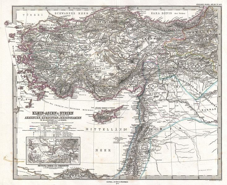
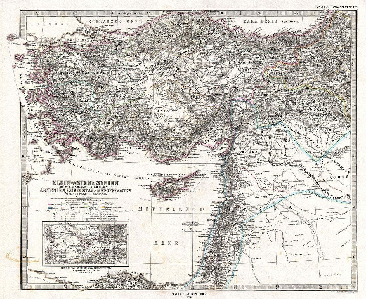
| Justus Perthes: Klein-Asien & Syrien nebst Den Westlichen Theilen von Armenien, Kurdistan & Mesopotamien.
( |
||||||
|---|---|---|---|---|---|---|
| 화가 | ||||||
| 제목 |
Klein-Asien & Syrien nebst Den Westlichen Theilen von Armenien, Kurdistan & Mesopotamien. |
|||||
| 설명 |
English: This is a beautiful example of Stieler’s 1873 map of the modern day Turkey, Syria, Israel / Palestine and Cyprus. Highly detailed with both political and physical data. Shows cities, mountains, roads, rivers and local divisions. An inset in the lower left quadrant features the vicinity of Smyrna (modern Ismir), including depth sounding in the Gulf of Smyrna and harbor. Printed to a high production standard, as was typical of German and especially Perthes/Stieler maps of this period. Published by the Justus Perthes firm and engraved by F. Eulenstein and C. Jungmann for issue as plate no. 43 in the 1873 edition of Stieler’s Hand-Atlas . |
|||||
| 날짜 | 1873년 (dated) | |||||
| 크기 | 높이: 13.5 in (34.2 cm); 너비: 16.6 in (42.1 cm) | |||||
| 일련 번호 |
Geographicus link: Klein-AsienSyrien-stieler-1873 |
|||||
| 출처/촬영자 |
Stieler's Hand-Atlas (1873 issue).
|
|||||
| 저작권 (이 파일을 인용하기) |
|
|||||

_-_Geographicus_-_Klein-AsienSyrien-stieler-1873.jpg?uselang=ko)
파일 역사
날짜/시간 링크를 클릭하면 해당 시간의 파일을 볼 수 있습니다.
| 날짜/시간 | 섬네일 | 크기 | 사용자 | 설명 | |
|---|---|---|---|---|---|
| 현재 | 2011년 3월 18일 (금) 17:02 | | 4,000 × 3,270 (3.79 MB) | BotMultichill | {{subst:User:Multichill/Geographicus |link=http://www.geographicus.com/P/AntiqueMap/Klein-AsienSyrien-stieler-1873 |product_name=1873 Stieler Map of Asia Minor, Syria and Israel - Palestine (modern Turkey) |map_title=Klein-Asien & Syrien nebst Den Westlic |
이 파일을 사용하는 문서
다음 문서 1개가 이 파일을 사용하고 있습니다:
이 파일을 사용하고 있는 모든 위키의 문서 목록
다음 위키에서 이 파일을 사용하고 있습니다:
- ar.wikipedia.org에서 이 파일을 사용하고 있는 문서 목록
- az.wikipedia.org에서 이 파일을 사용하고 있는 문서 목록
- bn.wikipedia.org에서 이 파일을 사용하고 있는 문서 목록
- en.wikipedia.org에서 이 파일을 사용하고 있는 문서 목록
- eo.wikipedia.org에서 이 파일을 사용하고 있는 문서 목록
- it.wikipedia.org에서 이 파일을 사용하고 있는 문서 목록
- mk.wikipedia.org에서 이 파일을 사용하고 있는 문서 목록
- mt.wikipedia.org에서 이 파일을 사용하고 있는 문서 목록
- pnb.wikipedia.org에서 이 파일을 사용하고 있는 문서 목록
- sl.wikipedia.org에서 이 파일을 사용하고 있는 문서 목록
- tr.wikipedia.org에서 이 파일을 사용하고 있는 문서 목록
- ur.wikipedia.org에서 이 파일을 사용하고 있는 문서 목록
_-_Geographicus_-_Klein-AsienSyrien-stieler-1873.jpg)