
파일:Alexander archipelago.jpg

미리 보기 크기: 450 × 600 픽셀 다른 해상도: 180 × 240 픽셀 | 360 × 480 픽셀 | 576 × 768 픽셀 | 1,050 × 1,400 픽셀
원본 파일 (1,050 × 1,400 픽셀, 파일 크기: 529 KB, MIME 종류: image/jpeg)
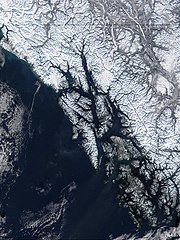
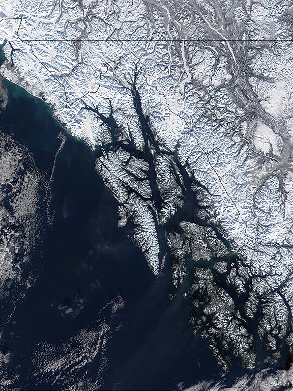
| 설명 | West of British Columbia, Canada, and south of the Yukon Territory, the southeastern coastline of Alaska trails off into the islands of the Alexander Archipelago. The area is rugged and contains many long, U-shaped, glaciated valleys, many of which terminate at tidewater. The Alexander Archipelago is home to Glacier Bay National Park. The large bay that has two forks on its northern end is Glacier Bay itself. The eastern fork is Muir inlet, into which runs the Muir glacier, named for the famous Scottish-born naturalist John Muir. Glacier Bay opens up into the Icy Strait. The large, solid white area to the west is Brady Icefield, which terminates at the southern end in Brady's Glacier. |
| 날짜 | |
| 출처 | https://visibleearth.nasa.gov/images/57719/alexander-archipelago-southeastern-alaska |
| 저자 | Jacques Descloitres, MODIS Land Rapid Response Team, NASA/GSFC |
| 이 파일은 NASA에서 제작하였으므로 퍼블릭 도메인입니다. NASA의 저작권 정책에 따르면 NASA의 자료는 명시하지 않는 이상 저작권의 보호를 받지 않습니다. (Template:PD-USGov, 또는 NASA 저작권 정책 문서, JPL 그림 사용 정책을 참고하세요.) | ||
 |
주의사항:
|
파일 역사
날짜/시간 링크를 클릭하면 해당 시간의 파일을 볼 수 있습니다.
| 날짜/시간 | 섬네일 | 크기 | 사용자 | 설명 | |
|---|---|---|---|---|---|
| 현재 | 2005년 6월 1일 (수) 18:32 | | 1,050 × 1,400 (529 KB) | Alib | NASA MODIS satellite image of the Alexander archipelago, Alaska |
이 파일을 사용하는 문서
다음 문서 1개가 이 파일을 사용하고 있습니다:
이 파일을 사용하고 있는 모든 위키의 문서 목록
다음 위키에서 이 파일을 사용하고 있습니다:
- ar.wikipedia.org에서 이 파일을 사용하고 있는 문서 목록
- arz.wikipedia.org에서 이 파일을 사용하고 있는 문서 목록
- ast.wikipedia.org에서 이 파일을 사용하고 있는 문서 목록
- az.wikipedia.org에서 이 파일을 사용하고 있는 문서 목록
- be.wikipedia.org에서 이 파일을 사용하고 있는 문서 목록
- ca.wikipedia.org에서 이 파일을 사용하고 있는 문서 목록
- ceb.wikipedia.org에서 이 파일을 사용하고 있는 문서 목록
- cs.wikipedia.org에서 이 파일을 사용하고 있는 문서 목록
- da.wikipedia.org에서 이 파일을 사용하고 있는 문서 목록
- de.wikipedia.org에서 이 파일을 사용하고 있는 문서 목록
- en.wikipedia.org에서 이 파일을 사용하고 있는 문서 목록
- en.wikivoyage.org에서 이 파일을 사용하고 있는 문서 목록
- eo.wikipedia.org에서 이 파일을 사용하고 있는 문서 목록
- es.wikipedia.org에서 이 파일을 사용하고 있는 문서 목록
- et.wikipedia.org에서 이 파일을 사용하고 있는 문서 목록
- eu.wikipedia.org에서 이 파일을 사용하고 있는 문서 목록
- fa.wikipedia.org에서 이 파일을 사용하고 있는 문서 목록
- fi.wikipedia.org에서 이 파일을 사용하고 있는 문서 목록
- fr.wikipedia.org에서 이 파일을 사용하고 있는 문서 목록
이 파일의 더 많은 사용 내역을 봅니다.