
파일:British Decolonisation in Africa.png
미리 보기 크기: 600 × 600 픽셀 다른 해상도: 240 × 240 픽셀 | 480 × 480 픽셀 | 768 × 768 픽셀 | 1,024 × 1,024 픽셀 | 2,000 × 2,000 픽셀
원본 파일 (2,000 × 2,000 픽셀, 파일 크기: 406 KB, MIME 종류: image/png)
파일 설명

|
이 그림 파일은 벡터 SVG 형식으로 다시 만들어야 합니다. SVG의 장점에 대해서는 여기(영어)를 참고해 주십시오. 만약 이 그림의 SVG 버전이 이미 존재한다면 이 틀을 {{vector version available|새 파일 이름.svg}}으로 대체해 주십시오.
|
| 설명 |
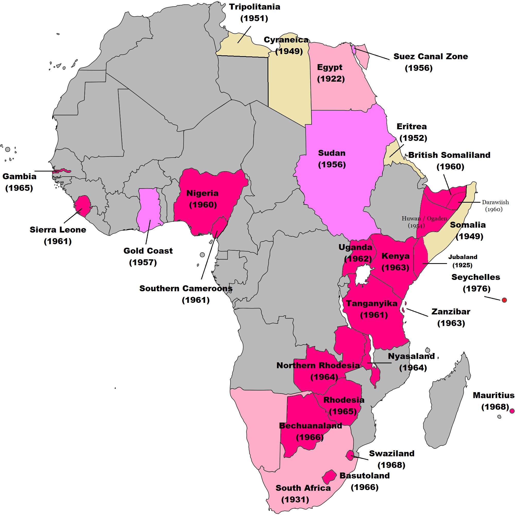
English: Map of British decolonisation in Africa. The beige areas were under British military administration after WW2. The different shades of pink refer to the stages of decolonization according to decades. |
| 날짜 | 2008년 11월 1일 (원본 올리기 일시) |
| 출처 |
Transferred from en.wikipedia; transfer was stated to be made by User:Hejsa. Blank map from File:BlankMap-World3.svg . Original text:
|
| 저자 | The Red Hat of Pat Ferrick t (log) |
| 저작권 (이 파일을 인용하기) |
Released into the public domain (by the author). |
라이선스
| |
이 작품은 위키미디어 공용의 The Red Hat of Pat Ferrick 사용자가 퍼블릭 도메인으로 공개한 작품입니다. 이 공개 선언은 전세계적으로 유효합니다. 만약 저작권의 포기가 법률적으로 가능하지 않은 경우, |
기존 올리기 기록
The original description page was here. All following user names refer to en.wikipedia.
- 2008-11-02 00:56 The Red Hat of Pat Ferrick 757×785× (171674 bytes) {{Information |Description=Map of British decolonisation in Africa. |Source=I created this work entirely by myself. |Date=1 November 2008 |Author=~~~ |other_versions= }}
파일 역사
날짜/시간 링크를 클릭하면 해당 시간의 파일을 볼 수 있습니다.
| 날짜/시간 | 섬네일 | 크기 | 사용자 | 설명 | |
|---|---|---|---|---|---|
| 현재 | 2021년 11월 8일 (월) 17:49 | | 2,000 × 2,000 (406 KB) | Randomastwritter | ogaden |
| 2021년 10월 30일 (토) 12:23 |  | 2,000 × 2,000 (399 KB) | Randomastwritter | juba | |
| 2013년 12월 7일 (토) 10:38 |  | 2,000 × 2,000 (396 KB) | Zello | corrected map that better reflects historical realities (for example South-West Africa, Rhodesia), also Mauritius and Seychelle added, and new colour for territories under temporary military administration after WW2 | |
| 2013년 11월 23일 (토) 03:52 |  | 757 × 785 (159 KB) | Zello | Somalia became a UN Trust Territory under Italian administration in 1949. The correction was requested also on the talk page. | |
| 2009년 9월 14일 (월) 01:08 |  | 757 × 785 (168 KB) | Hejsa | {{Information |Description={{en|Map of British decolonisation in Africa.}} |Source=Transferred from [http://en.wikipedia.org en.wikipedia]; transfer was stated to be made by User:Hejsa. |Date=1 November 2008<br/> ({{Date|2008|11|02}} (original upload |
이 파일을 사용하는 문서
다음 문서 3개가 이 파일을 사용하고 있습니다:
이 파일을 사용하고 있는 모든 위키의 문서 목록
다음 위키에서 이 파일을 사용하고 있습니다:
- ar.wikipedia.org에서 이 파일을 사용하고 있는 문서 목록
- ast.wikipedia.org에서 이 파일을 사용하고 있는 문서 목록
- azb.wikipedia.org에서 이 파일을 사용하고 있는 문서 목록
- az.wikipedia.org에서 이 파일을 사용하고 있는 문서 목록
- ba.wikipedia.org에서 이 파일을 사용하고 있는 문서 목록
- cs.wikipedia.org에서 이 파일을 사용하고 있는 문서 목록
- da.wikipedia.org에서 이 파일을 사용하고 있는 문서 목록
- de.wikipedia.org에서 이 파일을 사용하고 있는 문서 목록
- el.wikipedia.org에서 이 파일을 사용하고 있는 문서 목록
- en.wikipedia.org에서 이 파일을 사용하고 있는 문서 목록
- British Empire
- History of the United Kingdom
- Zimbabwe
- Harold Macmillan
- Balkanization
- Decolonization
- Cold War (1953–1962)
- Decolonisation of Africa
- List of national border changes (1914–present)
- Contemporary history
- Portal:Modern history
- User:Jr8825/sandbox 3
- User:Guettarda/Sandbox 50
- User:Falcaorib/Africa
- eu.wikipedia.org에서 이 파일을 사용하고 있는 문서 목록
- fr.wikipedia.org에서 이 파일을 사용하고 있는 문서 목록
- fr.wikiversity.org에서 이 파일을 사용하고 있는 문서 목록
- hy.wikipedia.org에서 이 파일을 사용하고 있는 문서 목록
- id.wikipedia.org에서 이 파일을 사용하고 있는 문서 목록
- it.wikipedia.org에서 이 파일을 사용하고 있는 문서 목록
- ka.wikipedia.org에서 이 파일을 사용하고 있는 문서 목록
- lv.wikipedia.org에서 이 파일을 사용하고 있는 문서 목록
- ms.wikipedia.org에서 이 파일을 사용하고 있는 문서 목록
- nl.wikipedia.org에서 이 파일을 사용하고 있는 문서 목록
- no.wikipedia.org에서 이 파일을 사용하고 있는 문서 목록
- pl.wikipedia.org에서 이 파일을 사용하고 있는 문서 목록
- pt.wikipedia.org에서 이 파일을 사용하고 있는 문서 목록
- ru.wikipedia.org에서 이 파일을 사용하고 있는 문서 목록
- si.wikipedia.org에서 이 파일을 사용하고 있는 문서 목록
- th.wikipedia.org에서 이 파일을 사용하고 있는 문서 목록
- tr.wikipedia.org에서 이 파일을 사용하고 있는 문서 목록
- uk.wikipedia.org에서 이 파일을 사용하고 있는 문서 목록
이 파일의 더 많은 사용 내역을 봅니다.