
파일:COVID-19 Outbreak Cases in New Zealand (DHB Totals).svg

SVG 파일의 PNG 형식의 미리보기 크기: 460 × 599 픽셀. 다른 해상도: 184 × 240 픽셀 | 369 × 480 픽셀 | 590 × 768 픽셀 | 787 × 1,024 픽셀 | 1,573 × 2,048 픽셀 | 650 × 846 픽셀
원본 파일 (SVG 파일, 실제 크기 650 × 846 픽셀, 파일 크기: 138 KB)
.svg?uselang=ko)
파일 설명

|
이 파일은 최신 정보를 받아서 업데이트될 가능성이 있습니다. 새로운 업데이트가 반영되는 것 없이, 특정 판의 파일을 사용한 경우에는, 필요한 판을 다른 파일로서 업로드해주세요. |
| 설명 |
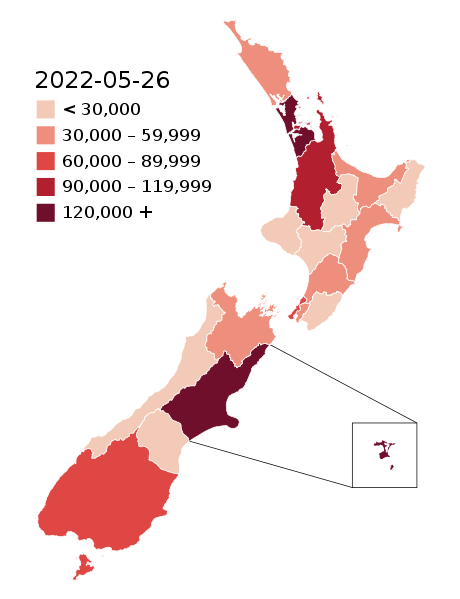
English: Map of the COVID-19 outbreak in New Zealand with case totals by District Health Board (DHB) as of 28 February 2022. Be aware that since this is a rapidly evolving situation, new cases may not be immediately represented visually. Refer to the primary article 2019–20 coronavirus outbreak by country and territory or the World Health Organization's situation reports for most recent reported case information.
The data ranges for each colour may be updated periodically to reflect changing data. Numerical ranges for each colour are calculated to give equally sized ranges. N.B: Stewart Island and Chatham Island are associated with the Southern DHB and Canterbury DHB (respectively). The colours for those islands represent the overall DHB case numbers, not the number of cases present on those islands specifically. |
| 날짜 | |
| 출처 |
|
| 저자 |
Base map: Base map: Stats NZ, edits by Air55 Colourisation: multiple authors |
.svg)
라이선스
이 파일은 크리에이티브 커먼즈 저작자표시-동일조건변경허락 4.0 국제 라이선스로 배포됩니다.
- 이용자는 다음의 권리를 갖습니다:
- 공유 및 이용 – 저작물의 복제, 배포, 전시, 공연 및 공중송신
- 재창작 – 저작물의 개작, 수정, 2차적저작물 창작
- 다음과 같은 조건을 따라야 합니다:
- 저작자표시 – 적절한 저작자 표시를 제공하고, 라이센스에 대한 링크를 제공하고, 변경사항이 있는지를 표시해야 합니다. 당신은 합리적인 방식으로 표시할 수 있지만, 어떤 방식으로든 사용권 허가자가 당신 또는 당신의 사용을 지지하는 방식으로 표시할 수 없습니다.
- 동일조건변경허락 – 만약 당신이 이 저작물을 리믹스 또는 변형하거나 이 저작물을 기반으로 제작하는 경우, 당신은 당신의 기여물을 원저작물과 동일하거나 호환 가능한 라이선스에 따라 배포하여야 합니다.
파일 역사
날짜/시간 링크를 클릭하면 해당 시간의 파일을 볼 수 있습니다.
.svg&dir=prev)
.svg&offset=20220129003640)
.svg&offset=&limit=20)
.svg&offset=&limit=50)
.svg&offset=&limit=100)
.svg&offset=&limit=250)
.svg&offset=&limit=500)
| 날짜/시간 | 섬네일 | 크기 | 사용자 | 설명 | |
|---|---|---|---|---|---|
| 현재 | 2022년 5월 26일 (목) 12:55 | | 650 × 846 (138 KB) | Air55 | Updated totals as of 26 May 2022 |
| 2022년 4월 3일 (일) 11:25 |  | 650 × 846 (138 KB) | Air55 | updated totals as of 2 April 2022 | |
| 2022년 3월 17일 (목) 16:47 |  | 650 × 846 (138 KB) | Air55 | updated totals | |
| 2022년 3월 8일 (화) 09:48 |  | 650 × 846 (138 KB) | Air55 | case totals + scale update | |
| 2022년 3월 6일 (일) 11:16 |  | 650 × 846 (138 KB) | Air55 | updated case totals | |
| 2022년 3월 2일 (수) 10:42 |  | 650 × 846 (138 KB) | Air55 | updated ranges | |
| 2022년 3월 2일 (수) 10:09 |  | 650 × 846 (138 KB) | Air55 | 02 March 2022 totals | |
| 2022년 3월 1일 (화) 13:43 |  | 650 × 846 (138 KB) | Air55 | Redid map. Legend now features in map for ease of updating across all pages, colour bins updated | |
| 2022년 3월 1일 (화) 12:06 |  | 650 × 846 (135 KB) | Air55 | updated as of 28 Feb. will be looking at making a new version of this map in light of the rapidly rising cases | |
| 2022년 1월 29일 (토) 09:36 |  | 650 × 846 (135 KB) | Air55 | Updated case totals for 28 January 2022. Colours changed for BOP, Lakes, and Canterbury DHBs. |
이 파일을 사용하는 문서
다음 문서 1개가 이 파일을 사용하고 있습니다:
이 파일을 사용하고 있는 모든 위키의 문서 목록
다음 위키에서 이 파일을 사용하고 있습니다:
- de.wikipedia.org에서 이 파일을 사용하고 있는 문서 목록
- en.wikipedia.org에서 이 파일을 사용하고 있는 문서 목록
- es.wikipedia.org에서 이 파일을 사용하고 있는 문서 목록
- fa.wikipedia.org에서 이 파일을 사용하고 있는 문서 목록
- fr.wikipedia.org에서 이 파일을 사용하고 있는 문서 목록
- he.wikipedia.org에서 이 파일을 사용하고 있는 문서 목록
- id.wikipedia.org에서 이 파일을 사용하고 있는 문서 목록
- ms.wikipedia.org에서 이 파일을 사용하고 있는 문서 목록
- nl.wikipedia.org에서 이 파일을 사용하고 있는 문서 목록
- ru.wikipedia.org에서 이 파일을 사용하고 있는 문서 목록
- simple.wikipedia.org에서 이 파일을 사용하고 있는 문서 목록
- sq.wikipedia.org에서 이 파일을 사용하고 있는 문서 목록
- th.wikipedia.org에서 이 파일을 사용하고 있는 문서 목록
- uk.wikipedia.org에서 이 파일을 사용하고 있는 문서 목록
- uz.wikipedia.org에서 이 파일을 사용하고 있는 문서 목록
- vi.wikipedia.org에서 이 파일을 사용하고 있는 문서 목록
- zh-yue.wikipedia.org에서 이 파일을 사용하고 있는 문서 목록
- zh.wikipedia.org에서 이 파일을 사용하고 있는 문서 목록
.svg)