
파일:Camargue map.png
최대 해상도입니다.
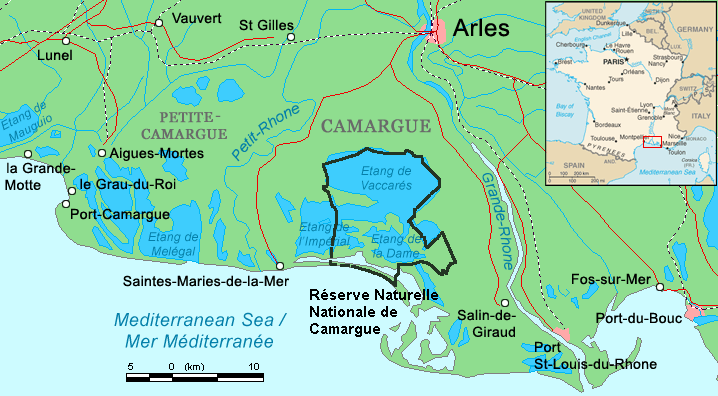
Camargue_map.png (718 × 396 픽셀, 파일 크기: 42 KB, MIME 종류: image/png)
파일 설명
| 설명 | ||||
| 날짜 | ||||
| 출처 | Combination of CIA World Factbook map (Image:Fr-map.png) and Demis Map Server (http://www2.demis.nl/mapserver/mapper.asp) data with additional annotations and modifications by self. | |||
| 저자 | ChrisO | |||
| 다른 버전 |
File:Camargue, Petite Caramgue et Parc naturel reg.png (relaunched and actualized)
|

파일 역사
날짜/시간 링크를 클릭하면 해당 시간의 파일을 볼 수 있습니다.
| 날짜/시간 | 섬네일 | 크기 | 사용자 | 설명 | |
|---|---|---|---|---|---|
| 현재 | 2016년 4월 30일 (토) 06:34 | | 718 × 396 (42 KB) | Rsuessbr | Writing of Petite-Camargue corrected |
| 2015년 8월 11일 (화) 02:15 |  | 718 × 396 (42 KB) | Rsuessrb | Added: limits of the natural park (according to a map published by snpn (Société Nationale de Protection de la Nature), 2015 | |
| 2012년 3월 20일 (화) 10:23 |  | 718 × 396 (38 KB) | Ras67 | cropped | |
| 2006년 8월 17일 (목) 05:52 |  | 720 × 398 (41 KB) | ChrisO | Map of the Camargue region, southern France By ~~~, derived from open source mapping | |
| 2006년 8월 17일 (목) 05:46 |  | 720 × 398 (40 KB) | ChrisO | Map of the Camargue region, southern France By ~~~, derived from open source mapping |
이 파일을 사용하는 문서
다음 문서 1개가 이 파일을 사용하고 있습니다:
이 파일을 사용하고 있는 모든 위키의 문서 목록
다음 위키에서 이 파일을 사용하고 있습니다:
- af.wikipedia.org에서 이 파일을 사용하고 있는 문서 목록
- ar.wikipedia.org에서 이 파일을 사용하고 있는 문서 목록
- az.wikipedia.org에서 이 파일을 사용하고 있는 문서 목록
- br.wikipedia.org에서 이 파일을 사용하고 있는 문서 목록
- co.wikipedia.org에서 이 파일을 사용하고 있는 문서 목록
- cs.wikipedia.org에서 이 파일을 사용하고 있는 문서 목록
- cy.wikipedia.org에서 이 파일을 사용하고 있는 문서 목록
- de.wikipedia.org에서 이 파일을 사용하고 있는 문서 목록
- en.wikipedia.org에서 이 파일을 사용하고 있는 문서 목록
- eo.wikipedia.org에서 이 파일을 사용하고 있는 문서 목록
- es.wikipedia.org에서 이 파일을 사용하고 있는 문서 목록
- fi.wikipedia.org에서 이 파일을 사용하고 있는 문서 목록
- fr.wikipedia.org에서 이 파일을 사용하고 있는 문서 목록
- gl.wikipedia.org에서 이 파일을 사용하고 있는 문서 목록
- hu.wikipedia.org에서 이 파일을 사용하고 있는 문서 목록
- id.wikipedia.org에서 이 파일을 사용하고 있는 문서 목록
- it.wikipedia.org에서 이 파일을 사용하고 있는 문서 목록
- ja.wikipedia.org에서 이 파일을 사용하고 있는 문서 목록
- lt.wikipedia.org에서 이 파일을 사용하고 있는 문서 목록
- nl.wikipedia.org에서 이 파일을 사용하고 있는 문서 목록
- nn.wikipedia.org에서 이 파일을 사용하고 있는 문서 목록
- no.wikipedia.org에서 이 파일을 사용하고 있는 문서 목록
- oc.wikipedia.org에서 이 파일을 사용하고 있는 문서 목록
이 파일의 더 많은 사용 내역을 봅니다.