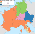
파일:Carolingian empire 876.svg

SVG 파일의 PNG 형식의 미리보기 크기: 621 × 599 픽셀. 다른 해상도: 249 × 240 픽셀 | 497 × 480 픽셀 | 796 × 768 픽셀 | 1,061 × 1,024 픽셀 | 2,122 × 2,048 픽셀 | 1,091 × 1,053 픽셀
원본 파일 (SVG 파일, 실제 크기 1,091 × 1,053 픽셀, 파일 크기: 149 KB)
파일 역사
날짜/시간 링크를 클릭하면 해당 시간의 파일을 볼 수 있습니다.
| 날짜/시간 | 섬네일 | 크기 | 사용자 | 설명 | |
|---|---|---|---|---|---|
| 현재 | 2016년 9월 1일 (목) 23:56 |  | 1,091 × 1,053 (149 KB) | Rowanwindwhistler | https://en.wikipedia.org/wiki/Wikipedia:WikiProject_Maps/Conventions http://colorbrewer2.org/#type=sequential&scheme=YlOrBr&n=5 |
| 2010년 5월 15일 (토) 06:10 |  | 1,091 × 1,053 (1.96 MB) | Trasamundo | Carlomán de Baviera | |
| 2010년 3월 14일 (일) 06:19 |  | 1,091 × 1,053 (1.96 MB) | Trasamundo | Alsace and northern Burgundian pagi to Charles the Fat | |
| 2010년 3월 14일 (일) 04:04 |  | 1,091 × 1,053 (1.89 MB) | Trasamundo | legend again | |
| 2010년 3월 14일 (일) 04:01 |  | 1,091 × 1,053 (1.89 MB) | Trasamundo | legend | |
| 2010년 3월 14일 (일) 03:57 |  | 1,091 × 1,053 (1.89 MB) | Trasamundo | {{Information |Description={{es|1=Imperio carolingio de Carlos II el Calvo}} |Source={{own}} |Author=Trasamundo |Date=13 March 2010 |Permission= |other_versions= }} Category:Maps of the Carolingian Empire |
이 파일을 사용하는 문서
다음 문서 1개가 이 파일을 사용하고 있습니다:
이 파일을 사용하고 있는 모든 위키의 문서 목록
다음 위키에서 이 파일을 사용하고 있습니다:
- ca.wikipedia.org에서 이 파일을 사용하고 있는 문서 목록
- el.wikipedia.org에서 이 파일을 사용하고 있는 문서 목록
- en.wikipedia.org에서 이 파일을 사용하고 있는 문서 목록
- es.wikipedia.org에서 이 파일을 사용하고 있는 문서 목록
- frr.wikipedia.org에서 이 파일을 사용하고 있는 문서 목록
- fy.wikipedia.org에서 이 파일을 사용하고 있는 문서 목록
- hy.wikipedia.org에서 이 파일을 사용하고 있는 문서 목록
- it.wikipedia.org에서 이 파일을 사용하고 있는 문서 목록
- nl.wikipedia.org에서 이 파일을 사용하고 있는 문서 목록
- nn.wikipedia.org에서 이 파일을 사용하고 있는 문서 목록
- no.wikipedia.org에서 이 파일을 사용하고 있는 문서 목록
- pl.wikipedia.org에서 이 파일을 사용하고 있는 문서 목록
- ru.wikipedia.org에서 이 파일을 사용하고 있는 문서 목록
- sl.wikipedia.org에서 이 파일을 사용하고 있는 문서 목록

