
파일:Ceratopsian map.png

미리 보기 크기: 800 × 352 픽셀 다른 해상도: 320 × 141 픽셀 | 640 × 282 픽셀 | 1,427 × 628 픽셀
원본 파일 (1,427 × 628 픽셀, 파일 크기: 72 KB, MIME 종류: image/png)
File:Ceratopsian map.png requires updating
Hi Ceratopsian map.png,
Thank you for your contributions to Commons. I noticed File:Ceratopsian map.png is out of date. Does not include localitiy of Ferrisaurus Could you update it? Thanks again. Extrapolaris (토론) 01:17, 11 November 2019 (UTC) Vahe Demirjian
- @Extrapolaris: Done. Thanks for informing me, next time you could leave message on my talk page directly (in traditional Chinese) so I can see it sooner. -- Tiouraren (토론) 10:21, 31 January 2020 (UTC)
파일 설명
| 설명 |
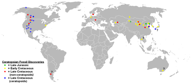
English: Map of ceratopsian fossil localities as of September 2006. I used the blank political map of the world commonly used on Wikipedia ((BlankMap-World.png).
Keep in mind that the land masses would not have been in the same places they are today in the Jurassic and Cretaceous periods. |
| 날짜 | 2009년 3월 17일 (원본 올리기 일시) |
| 출처 | FunkMonk 사용자가 CommonsHelper 도구를 사용하여 en.wikipedia에서 공용으로 옮겨왔습니다. |
| 저자 | 영어 위키백과의 Sheep81 |
라이선스
| 이 작품은 저작자인 영어 위키백과의 Sheep81에 의해 퍼블릭 도메인으로 공개된 작품입니다. 이 공개 선언은 전 세계적으로 유효합니다. 만약 저작권의 포기가 법률적으로 가능하지 않은 경우, Sheep81은 이 작품을 법적으로 허용되는 한도 내에서 누구나 자유롭게 어떤 목적으로도 제한 없이 사용할 수 있도록 허용합니다. |
기존 올리기 기록
The original description page was here. All following user names refer to en.wikipedia.
- 2009-03-17 18:48 Dinoguy2 1427×628× (47473 bytes) ''Turanoceratops'' as a ceratopsid, not non-ceratopsid (red dot -> blue dot).
- 2006-09-20 06:18 Sheep81 1427×628× (45407 bytes)
- 2006-09-20 04:44 Sheep81 1427×628× (45348 bytes) Map of ceratopsian fossil localities as of September 2006. I used the blank political map of the world commonly used on Wikipedia ((BlankMap-World.png). Keep in mind that the land masses would not have been in the same places they are today in the Jurass
파일 역사
날짜/시간 링크를 클릭하면 해당 시간의 파일을 볼 수 있습니다.
| 날짜/시간 | 섬네일 | 크기 | 사용자 | 설명 | |
|---|---|---|---|---|---|
| 현재 | 2020년 1월 31일 (금) 19:11 | | 1,427 × 628 (72 KB) | Tiouraren | Added the locality of Ferrisaurus |
| 2019년 7월 31일 (수) 15:07 |  | 1,427 × 628 (72 KB) | Tiouraren | fixing political border | |
| 2019년 7월 17일 (수) 23:51 |  | 1,427 × 628 (71 KB) | Tiouraren | Records from Sweden (Lindgren et al., 2007) and Japan (Manabe et al., 2016) added | |
| 2019년 7월 14일 (일) 16:38 |  | 1,427 × 628 (70 KB) | Tiouraren | Add locality of 50+ basal ceratopsian fossils and Crittendenceratops. | |
| 2019년 7월 14일 (일) 15:18 |  | 1,427 × 628 (70 KB) | Tiouraren | Turanocertops update | |
| 2018년 7월 4일 (수) 15:53 |  | 1,427 × 628 (61 KB) | Tiouraren | Add ''Sinoceratops'', ''Koreaceratops'', ''Yehuecauhceratops'', and ''Machairoceratops'' | |
| 2009년 3월 27일 (금) 06:46 |  | 1,427 × 628 (46 KB) | File Upload Bot (Magnus Manske) | {{BotMoveToCommons|en.wikipedia|year={{subst:CURRENTYEAR}}|month={{subst:CURRENTMONTHNAME}}|day={{subst:CURRENTDAY}}}} {{Information |Description={{en|Map of ceratopsian fossil localities as of September 2006. I used the blank political map of the world |
이 파일을 사용하는 문서
다음 문서 1개가 이 파일을 사용하고 있습니다:
이 파일을 사용하고 있는 모든 위키의 문서 목록
다음 위키에서 이 파일을 사용하고 있습니다:
- en.wikipedia.org에서 이 파일을 사용하고 있는 문서 목록
- es.wikipedia.org에서 이 파일을 사용하고 있는 문서 목록
- hr.wikipedia.org에서 이 파일을 사용하고 있는 문서 목록
- hu.wikipedia.org에서 이 파일을 사용하고 있는 문서 목록
- ml.wikipedia.org에서 이 파일을 사용하고 있는 문서 목록
- pl.wikipedia.org에서 이 파일을 사용하고 있는 문서 목록
- sh.wikipedia.org에서 이 파일을 사용하고 있는 문서 목록
- tr.wikipedia.org에서 이 파일을 사용하고 있는 문서 목록
- uk.wikipedia.org에서 이 파일을 사용하고 있는 문서 목록
- zh.wikipedia.org에서 이 파일을 사용하고 있는 문서 목록