
파일:Civitas Londinium or The Agas Map of London.jpg

미리 보기 크기: 800 × 338 픽셀 다른 해상도: 320 × 135 픽셀 | 640 × 271 픽셀 | 1,024 × 433 픽셀 | 1,280 × 541 픽셀 | 4,730 × 2,000 픽셀
원본 파일 (4,730 × 2,000 픽셀, 파일 크기: 4.08 MB, MIME 종류: image/jpeg)
파일 설명
| 설명 |
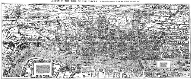
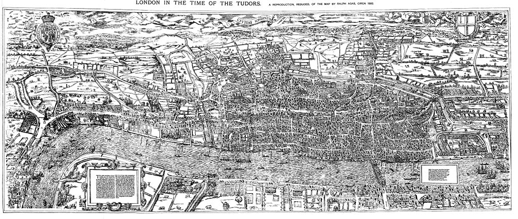
English: The earliest proper map (as opposed to panorama) of London known. Attributed to Ralph Agas, and probably surveyed between 1570 and 1605. The original was 6 foot 0.5 inches long by 2 feet 4.5 inches wide. This much reduced image is a scan of a copy of a lithograph of a copy, was itself badly repaired with sellotape and has had to be "restored"; so is hardly a truly faithful representation of the original, but few good copies exist and no other detailed public domain images are known. |
| 날짜 | |
| 출처 | Maps of Old London, London, Adam and Charles Black, 1908. Scanned & corrected Mike Calder. |
| 저자 | Mike Calder, image of Civitas Londinium, Agas' Map of London, c. 1570-1605 |
| 다른 버전 | 이 파일은 다음으로 파생됨: Covent Garden from the Ralph Agas 1572 map of London.jpg |
라이선스
|
이 작품은 미국, 그리고 저작권 보호 기간이 저작자 사후 100년, 또는 그 이하인 모든 국가에서 퍼블릭 도메인입니다. | |
| 이 저작물은 모든 저작인접권을 포함한 저작권법하의 규제로부터 자유로운 것으로 확인되었습니다. | |
파일 역사
날짜/시간 링크를 클릭하면 해당 시간의 파일을 볼 수 있습니다.
| 날짜/시간 | 섬네일 | 크기 | 사용자 | 설명 | |
|---|---|---|---|---|---|
| 현재 | 2009년 8월 15일 (토) 03:59 | | 4,730 × 2,000 (4.08 MB) | MikeCalder | {{Information |Description={{en|1=The earliest proper map (as opposed to panorama) of London known. Attributed to Ralph Agas, and probably surveyed between 1570 and 1605. The original was 6 foot 0.5 inches long by 2 feet 4.5 inches wide. This much reduc |
이 파일을 사용하는 문서
다음 문서 1개가 이 파일을 사용하고 있습니다:
이 파일을 사용하고 있는 모든 위키의 문서 목록
다음 위키에서 이 파일을 사용하고 있습니다:
- af.wikipedia.org에서 이 파일을 사용하고 있는 문서 목록
- ar.wikipedia.org에서 이 파일을 사용하고 있는 문서 목록
- avk.wikipedia.org에서 이 파일을 사용하고 있는 문서 목록
- azb.wikipedia.org에서 이 파일을 사용하고 있는 문서 목록
- de.wikipedia.org에서 이 파일을 사용하고 있는 문서 목록
- el.wikipedia.org에서 이 파일을 사용하고 있는 문서 목록
- en.wikipedia.org에서 이 파일을 사용하고 있는 문서 목록
- es.wikipedia.org에서 이 파일을 사용하고 있는 문서 목록
- fa.wikipedia.org에서 이 파일을 사용하고 있는 문서 목록
- hy.wikipedia.org에서 이 파일을 사용하고 있는 문서 목록
- it.wikipedia.org에서 이 파일을 사용하고 있는 문서 목록
- ja.wikipedia.org에서 이 파일을 사용하고 있는 문서 목록
- la.wikipedia.org에서 이 파일을 사용하고 있는 문서 목록
- pt.wikipedia.org에서 이 파일을 사용하고 있는 문서 목록
- ro.wikipedia.org에서 이 파일을 사용하고 있는 문서 목록
- ru.wikipedia.org에서 이 파일을 사용하고 있는 문서 목록
- simple.wikipedia.org에서 이 파일을 사용하고 있는 문서 목록
- sl.wikipedia.org에서 이 파일을 사용하고 있는 문서 목록
- tr.wikipedia.org에서 이 파일을 사용하고 있는 문서 목록
- uk.wikipedia.org에서 이 파일을 사용하고 있는 문서 목록
- zh.wikipedia.org에서 이 파일을 사용하고 있는 문서 목록