
파일:Cooch-behar-enclaves-schematisch.png
미리 보기 크기: 307 × 599 픽셀 다른 해상도: 123 × 240 픽셀 | 246 × 480 픽셀 | 393 × 768 픽셀 | 1,100 × 2,148 픽셀
원본 파일 (1,100 × 2,148 픽셀, 파일 크기: 694 KB, MIME 종류: image/png)

|
이 그림 파일은 벡터 SVG 형식으로 다시 만들어야 합니다. SVG의 장점에 대해서는 여기(영어)를 참고해 주십시오. 만약 이 그림의 SVG 버전이 이미 존재한다면 이 틀을 {{vector version available|새 파일 이름.svg}}으로 대체해 주십시오.
|
파일 설명
| 설명 |
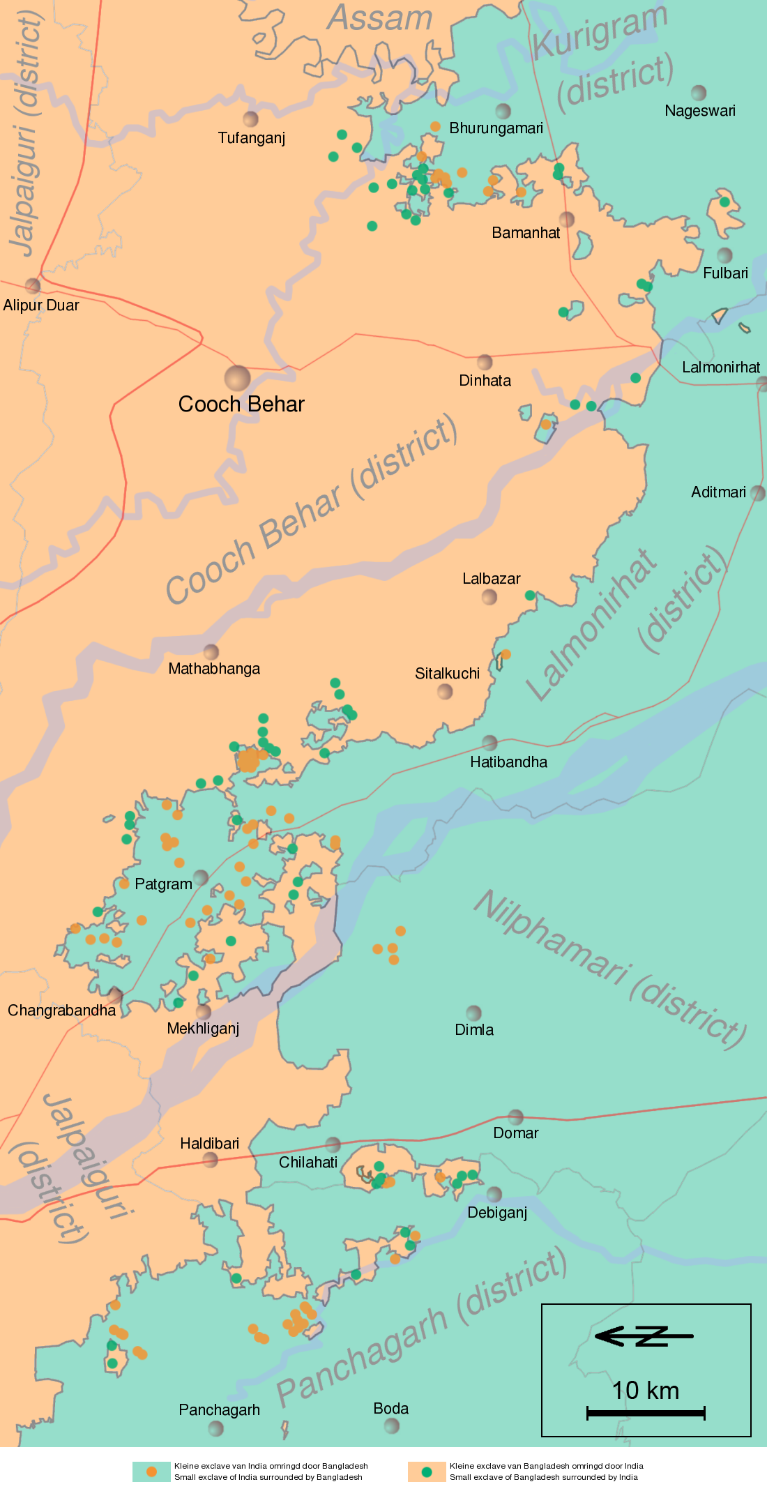
English: Schematic map of the Cooch Behar enclaves on the border of India and Bangladesh. The top of the map points to the east.
Nederlands: Schematische kaart van de Cooch Behar enclaves op de grens van India en Bangladesh. De bovenkant wijst naar het oosten. |
| 날짜 | (UTC) |
| 출처 | Information in "Waiting for the esquimo: An historical and documentary study of the Cooch Behar enclaves of India and Bangladesh" door Brendan R. Whyte (2002), [1], Google Maps and other map sources |
| 저자 | Jeroen |
![[1]](http://geosite.jankrogh.com/enklaver/CoochBehar_Annotated.jpg)
라이선스
나는 아래 작품의 저작권자로서, 이 저작물을 다음과 같은 라이선스로 배포합니다:

|
GNU 자유 문서 사용 허가서 1.2판 또는 자유 소프트웨어 재단에서 발행한 이후 판의 규정에 따라 본 문서를 복제하거나 개작 및 배포할 수 있습니다. 본 문서에는 변경 불가 부분이 없으며, 앞 표지 구절과 뒷 표지 구절도 없습니다. 본 사용 허가서의 전체 내용은 GNU 자유 문서 사용 허가서 부분에 포함되어 있습니다. |
| 이 파일은 크리에이티브 커먼즈 저작자표시-동일조건변경허락 3.0 Unported 라이선스로 배포됩니다. | ||
| ||
| 이 라이선스 틀은 GFDL 라이선스 변경의 일부로 이 파일에 추가되었습니다. |
- 이용자는 다음의 권리를 갖습니다:
- 공유 및 이용 – 저작물의 복제, 배포, 전시, 공연 및 공중송신
- 재창작 – 저작물의 개작, 수정, 2차적저작물 창작
- 다음과 같은 조건을 따라야 합니다:
- 저작자표시 – 적절한 저작자 표시를 제공하고, 라이센스에 대한 링크를 제공하고, 변경사항이 있는지를 표시해야 합니다. 당신은 합리적인 방식으로 표시할 수 있지만, 어떤 방식으로든 사용권 허가자가 당신 또는 당신의 사용을 지지하는 방식으로 표시할 수 없습니다.
- 동일조건변경허락 – 만약 당신이 이 저작물을 리믹스 또는 변형하거나 이 저작물을 기반으로 제작하는 경우, 당신은 당신의 기여물을 원저작물과 동일하거나 호환 가능한 라이선스에 따라 배포하여야 합니다.
이 라이선스 중에서 목적에 맞는 것을 선택하여 사용할 수 있습니다.
기존 올리기 기록
| date/time | username | resolution | size | edit summary | |
|---|---|---|---|---|---|
| 12:03, 12 April 2008 | User:Gpvos | <a href="http://upload.wikimedia.org/wikipedia/commons/2/22/Cooch-behar-enclaves-systematisch.png[dead link]"><img alt="Thumbnail for version as of 12:03, 12 April 2008" src="http://upload.wikimedia.org/wikipedia/commons/thumb/2/22/Cooch-behar-enclaves-systematisch.png/61px-Cooch-behar-enclaves-systematisch.png[dead link]" width="61" height="119" border="0" /></a> | 1,100×2,148 | 642 KB | spelling fix (also optimized png) {{self|GFDL|cc-by-sa-2.5,2.0,1.0|author=<a href="/wiki/User:Jeroen" class="mw-redirect" title="User:Jeroen">User:Jeroen</a>}} |
| 22:53, 14 May 2007 | User:Jeroencommons | <a href="http://upload.wikimedia.org/wikipedia/commons/archive/2/22/20080412120354%21Cooch-behar-enclaves-systematisch.png[dead link]"><img alt="Thumbnail for version as of 22:53, 14 May 2007" src="http://upload.wikimedia.org/wikipedia/commons/thumb/archive/2/22/20080412120354%21Cooch-behar-enclaves-systematisch.png/61px-Cooch-behar-enclaves-systematisch.png[dead link]" width="61" height="119" border="0" /></a> | 1,100×2,148 | 690 KB | |
| 21:22, 13 May 2007 | User:Jeroencommons | <a href="http://upload.wikimedia.org/wikipedia/commons/archive/2/22/20070514225354%21Cooch-behar-enclaves-systematisch.png[dead link]"><img alt="Thumbnail for version as of 21:22, 13 May 2007" src="http://upload.wikimedia.org/wikipedia/commons/thumb/archive/2/22/20070514225354%21Cooch-behar-enclaves-systematisch.png/61px-Cooch-behar-enclaves-systematisch.png[dead link]" width="61" height="119" border="0" /></a> | 1,100×2,148 | 691 KB | {{Information |Description= Systematische kaart van de Cooch Behar enclaves op de grens van India en Bangladesh // Systematic map of the Cooch Behar enclaves on the border of India and Bangladesh |Source= Information in [http://eprints.unimelb.edu.au/arch |
파일 역사
날짜/시간 링크를 클릭하면 해당 시간의 파일을 볼 수 있습니다.
| 날짜/시간 | 섬네일 | 크기 | 사용자 | 설명 | |
|---|---|---|---|---|---|
| 현재 | 2011년 11월 29일 (화) 22:11 | | 1,100 × 2,148 (694 KB) | W like wiki | scale and north added |
| 2008년 10월 5일 (일) 13:38 |  | 1,100 × 2,148 (642 KB) | BetacommandBot | move approved by: User:Common Good This image was moved from Image:Cooch-behar-enclaves-systematisch.png == {{int:filedesc}} == {{Information |Description= Schematische kaart van de Cooch Behar enclaves op de grens van India en Bangladesh. De b |
이 파일을 사용하는 문서
다음 문서 1개가 이 파일을 사용하고 있습니다:
이 파일을 사용하고 있는 모든 위키의 문서 목록
다음 위키에서 이 파일을 사용하고 있습니다:
- bn.wikipedia.org에서 이 파일을 사용하고 있는 문서 목록
- ca.wikipedia.org에서 이 파일을 사용하고 있는 문서 목록
- de.wikipedia.org에서 이 파일을 사용하고 있는 문서 목록
- en.wikipedia.org에서 이 파일을 사용하고 있는 문서 목록
- es.wikipedia.org에서 이 파일을 사용하고 있는 문서 목록
- fi.wikipedia.org에서 이 파일을 사용하고 있는 문서 목록
- fr.wikipedia.org에서 이 파일을 사용하고 있는 문서 목록
- Liste d'enclaves et d'exclaves
- Enclaves indo-bangladaises
- Discussion:Enclaves indo-bangladaises
- Utilisateur:GhosterBot/BacASable/Le saviez-vous ?/Archives
- Wikipédia:Le saviez-vous ?/Archives/2023
- Wikipédia:Statistiques des anecdotes de la page d'accueil/Visibilité des anecdotes (2023)
- Wikipédia:Statistiques des anecdotes de la page d'accueil/Visibilité des anecdotes (2023)/2023 09
- Discussion:Enclaves indo-bangladaises/LSV 22579
- Wikipédia:Réseaux sociaux/X/Publications/archives/septembre 2023
- hi.wikipedia.org에서 이 파일을 사용하고 있는 문서 목록
- id.wikipedia.org에서 이 파일을 사용하고 있는 문서 목록
- it.wikipedia.org에서 이 파일을 사용하고 있는 문서 목록
- ja.wikipedia.org에서 이 파일을 사용하고 있는 문서 목록
- mt.wikipedia.org에서 이 파일을 사용하고 있는 문서 목록
- nl.wikipedia.org에서 이 파일을 사용하고 있는 문서 목록
- pl.wikipedia.org에서 이 파일을 사용하고 있는 문서 목록
- pt.wikipedia.org에서 이 파일을 사용하고 있는 문서 목록
- ru.wikipedia.org에서 이 파일을 사용하고 있는 문서 목록
- sq.wikipedia.org에서 이 파일을 사용하고 있는 문서 목록
- te.wikipedia.org에서 이 파일을 사용하고 있는 문서 목록
- th.wikipedia.org에서 이 파일을 사용하고 있는 문서 목록
- uk.wikipedia.org에서 이 파일을 사용하고 있는 문서 목록
- www.wikidata.org에서 이 파일을 사용하고 있는 문서 목록
- xmf.wikipedia.org에서 이 파일을 사용하고 있는 문서 목록
- zh.wikipedia.org에서 이 파일을 사용하고 있는 문서 목록