
파일:Deathvalleysky nps big.jpg

미리 보기 크기: 800 × 258 픽셀 다른 해상도: 320 × 103 픽셀 | 640 × 206 픽셀 | 1,024 × 330 픽셀 | 1,280 × 412 픽셀 | 4,000 × 1,288 픽셀
원본 파일 (4,000 × 1,288 픽셀, 파일 크기: 1.19 MB, MIME 종류: image/jpeg)
파일 설명
| 설명 |
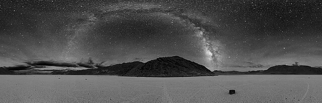
English: 360° panorama of Racetrack Playa in Death Valley at night. The Milky Way is visible as the arc in the center. A sailing stone is also seen below along with the tracks of other stones.
Deutsch: 360° Panorama-Foto der Racetrack Playa in Death Valley bei Nacht. Die Milchstraße ist als Bogen in der Mitte zu sehen. Zu sehen ist auch ein Wandernder Stein mit seiner Spur sowie die Spuren anderer wandernder Steine.
Español: Fotografía panorámica (360º) nocturna de Racetrack Playa en el Valle de la Muerte. En el centro de la imagen la Vía Láctea es visible con la apariencia de un arco luminoso.
Français : Photo nocturne panoramique (360°) de Racetrack Playa dans la vallée de la mort. L'arc de cercle étoilé correspond à notre voie lactée. Une pierre glissante se trouve au-dessous parmi les pistes d'autres pierres.
Українська: 360° панорама Чумацького Шляху над висохлим озером Рейстрек-Плайя у Долині смерті вночі, США. Внизу також видно вітрильний камінь разом із слідами інших каменів.
|
| 날짜 | |
| 출처 | http://antwrp.gsfc.nasa.gov/apod/ap070508.html |
| 저자 | Dan Duriscoe, for the en:U.S. National Park Service. |
| 다른 버전 |
|

| 360° | 360° 파노라마 뷰어로 보기
|
|---|
| 카메라 위치 | | 이 지역의 다른 사진을 보기: OpenStreetMap |
|---|
수상
|
이 이미지는 2022년 11월 12일의 오늘의 이미지로 선정되었습니다. 이미지 설명은 다음과 같습니다. English: 360° panorama of Racetrack Playa in Death Valley at night. The Milky Way is visible as the arc in the center. A sailing stone is also seen below along with the tracks of other stones. 다른 언어들:
Čeština: Panoramatický noční snímek s úhlem 360° vyschlého amerického jezera Racetrack Playa v Údolí smrti a galaxií Mléčná dráha v centru snímku nahoře. Deutsch: 360° Panorama-Foto der Racetrack Playa in Death Valley bei Nacht. Die Milchstraße ist als Bogen in der Mitte zu sehen. Zu sehen ist auch ein Wandernder Stein mit seiner Spur sowie die Spuren anderer wandernder Steine. English: 360° panorama of Racetrack Playa in Death Valley at night. The Milky Way is visible as the arc in the center. A sailing stone is also seen below along with the tracks of other stones. Español: Fotografía panorámica (360º) nocturna de Racetrack Playa en el Valle de la Muerte. En el centro de la imagen la Vía Láctea es visible con la apariencia de un arco luminoso. Français : Photo nocturne panoramique (360°) de Racetrack Playa dans la vallée de la mort. L'arc de cercle étoilé correspond à notre voie lactée. Une pierre glissante se trouve au-dessous parmi les pistes d'autres pierres. Magyar: A Racetrack Playa 360 fokos éjszakai panorámája. A kép közepén a Tejút látható egy fényes ív formájában. Alul egy vándorló kő, más kövek nyomai mellett (Death Valley Nemzeti Park, Inyo megye, Kalifornia) Nederlands: Nachtelijke 360-gradenfoto van Racetrack Playa in Death Valley in de Amerikaanse staat Californië. De boog in de lucht is de Melkweg, op de voorgrond ligt een van de glijdende rotsblokken. Português: Fotografia panorâmica (360°) noturna do lago seco Racetrack Playa no Parque Nacional do Vale da Morte. No centro da imagem a Via Láctea é visível com a aparência de um arco luminoso. Македонски: Сестрана слика (360°) на Долината на Смртта во САД. По средината се гледа Млечниот Пат во облик на лак. Русский: Круговая панорама Млечного пути над дном высохшего озера Рейстрек-Плайя с движущимися камнями в Долине Смерти, Калифорния Українська: 360° панорама Чумацького Шляху над висохлим озером Рейстрек-Плайя у Долині смерті вночі, США. Внизу також видно вітрильний камінь разом із слідами інших рухливих каменів. |
라이선스
| This image or media file contains material based on a work of a National Park Service employee, created as part of that person's official duties. As a work of the U.S. federal government, such work is in the public domain in the United States. See the NPS website and NPS copyright policy for more information. |
기존 올리기 기록
Originally from en.wikipedia; description page is/was here.
(All user names refer to en.wikipedia)
- 2007-05-09 01:15 Trialsanderrors 4000×1290×8 (1207310 bytes) Reverted to earlier revision
- 2007-05-08 16:04 Clh288 4000×1290×8 (1207310 bytes) This image of [[death vally]] at night was taken by Dan Duriscoe, for the [[U.S. National Park Service]]. http://antwrp.gsfc.nasa.gov/apod/astropix.html
| 주석 | 이 이미지에는 주석이 있습니다: 공용에서 주석을 보기 |
파일 역사
날짜/시간 링크를 클릭하면 해당 시간의 파일을 볼 수 있습니다.
| 날짜/시간 | 섬네일 | 크기 | 사용자 | 설명 | |
|---|---|---|---|---|---|
| 현재 | 2016년 11월 12일 (토) 01:00 | 4,000 × 1,288 (1.19 MB) | SteinsplitterBot | Bot: Image rotated by 180° | |
| 2007년 6월 25일 (월) 00:41 | 4,000 × 1,290 (1.15 MB) | MagpieShooter~commonswiki | {{Information |Description=This image of en:Racetrack Playa in en:Death Valley at night was taken by Dan Duriscoe, for the en:U.S. National Park Service. http://antwrp.gsfc.nasa.gov/apod/ap070508.html |Source=Originally from [http://en.wik |
이 파일을 사용하는 문서
다음 문서 3개가 이 파일을 사용하고 있습니다:
이 파일을 사용하고 있는 모든 위키의 문서 목록
다음 위키에서 이 파일을 사용하고 있습니다:
- alt.wikipedia.org에서 이 파일을 사용하고 있는 문서 목록
- an.wikipedia.org에서 이 파일을 사용하고 있는 문서 목록
- ar.wikipedia.org에서 이 파일을 사용하고 있는 문서 목록
- ast.wikipedia.org에서 이 파일을 사용하고 있는 문서 목록
- av.wikipedia.org에서 이 파일을 사용하고 있는 문서 목록
- ba.wikipedia.org에서 이 파일을 사용하고 있는 문서 목록
- be.wikipedia.org에서 이 파일을 사용하고 있는 문서 목록
- bn.wikipedia.org에서 이 파일을 사용하고 있는 문서 목록
- bxr.wikipedia.org에서 이 파일을 사용하고 있는 문서 목록
- ca.wikipedia.org에서 이 파일을 사용하고 있는 문서 목록
- ce.wikipedia.org에서 이 파일을 사용하고 있는 문서 목록
- crh.wikipedia.org에서 이 파일을 사용하고 있는 문서 목록
- cs.wikipedia.org에서 이 파일을 사용하고 있는 문서 목록
- cv.wikipedia.org에서 이 파일을 사용하고 있는 문서 목록
- de.wikipedia.org에서 이 파일을 사용하고 있는 문서 목록
- el.wikipedia.org에서 이 파일을 사용하고 있는 문서 목록
- en.wikipedia.org에서 이 파일을 사용하고 있는 문서 목록
- Death Valley National Park
- Sky
- Racetrack Playa
- User:Kerowyn
- User:Arsonal
- User talk:Clh288
- User:Clh288
- Sailing stones
- Wikipedia:Featured pictures thumbs/07
- User:Devinma
- Wikipedia:Featured picture candidates/The Milky Way over Death Vally
- Wikipedia:Featured picture candidates/June-2007
- Wikipedia:Wikipedia Signpost/2007-06-04/Features and admins
- Wikipedia:Wikipedia Signpost/2007-06-04/SPV
- Wikipedia:Picture of the day/September 2007
- Template:POTD/2007-09-15
- User talk:Ngc1972
- Talk:Milky Way/Archive 2
- User talk:Theindigowombat
- User:Helixer
- User:Sweetness46
- User:בינה תפארת
- User:Trum5770/B1
- Wikipedia:Featured pictures/Space/Panorama
이 파일의 더 많은 사용 내역을 봅니다.