
파일:Desierto de Lut, Irán, 2016-09-22, DD 71-86 HDR PAN.jpg

원본 파일 (13,835 × 4,230 픽셀, 파일 크기: 22.73 MB, MIME 종류: image/jpeg)
파일 설명
| 설명 |
Español: Vista panorámica HDR de aprox. 180 grados del desierto de Lut (Dasht-e Loot), que traudcido significa "Desierto del vacío", situados en las provincias de Kermán y Sistán y Baluchistán, Irán. Este parte del mundo tiene particularidad de haber registrado la mayor temperatura medida en la superficie de la tierra (70 °C) y es, desde julio de 2016, patrimonio de la Humanidad según la UNESCO.
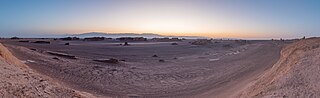
English: HDR panoramic view of approx. 180 degrees during sunset of Dasht-e Loot, in English "Emptiness desert", located in the provinces of Kerman and Sistan-Baluchistan, Iran. This place is pretty special for being the spot on the Earth where the highest temperature was ever measured (70 °C or 159 °F) and since July 2016 a UNESCO World Heritage Site.
Polski: Panorama pustyni Lut położonej w ostanach Kerman oraz Sistan i Beludżystan w Iranie. Jest to szczególne miejsce, ponieważ zanotowano tutaj najwyższą temperaturę gruntu na Ziemi, 70,7 °C, a od lipca 2016 pustynia znajduje się na liście światowego dziedzictwa UNESCO.
Українська: Панорамний вид прибл. 180° під час заходу сонця пустелі «Дашт-е Лут», («Пустеля порожнечі»), яка розташована в провінціях Керман та Сістан-Белуджистан, Іран. Це найжаркіше місце на Землі, де коли-небудь вимірювали найвищу температуру 70 °C. Всесвітня спадщина ЮНЕСКО з липня 2016 року.
Bahasa Indonesia: Pemandangan panoramik HDR Dasht-e-Loot ("Gurun Kekosongan"), provinsi Kerman dan Sistan-Baluchistan, Iran, sebesar rata-rata 180 derajat saat matahari terbenam. Situs Warisan Dunia UNESCO yang ditetapkan sejak bulan Juli 2016 ini adalah tempat dimana suhu tertinggi di Bumi pernah tercatat (70 °C or 159 °F). |
||||||||||||||||||||
| 날짜 | |||||||||||||||||||||
| 출처 | 자작 | ||||||||||||||||||||
| 저자 |
|
||||||||||||||||||||

| 카메라 위치 | | 이 지역의 다른 사진을 보기: OpenStreetMap |
|---|
|
이 이미지는 2022년 8월 16일의 오늘의 이미지로 선정되었습니다. 이미지 설명은 다음과 같습니다. English: HDR panoramic view of approx. 180 degrees during sunset of Dasht-e Loot, in English "Emptiness desert", located in the provinces of Kerman and Sistan-Baluchistan, Iran. This place is pretty special for being the spot on the Earth where the highest temperature was ever measured (70 °C or 159 °F) and since July 2016 a UNESCO World Heritage Site. 다른 언어들:
Čeština: Panoramatický snímek zachycující úhel 180 stupňů během západu slunce v oblasti solné pouště Lút (Dasht-e Loot), česky "Nejprázdnější poušt" v íránských provinciích Kermán a Sístán a Balúčistán. Na tomto místě byla zjištěna doposud nejvyšší změřená teplota na planetě Zemi - 78,2 °C a od července 2016 je oblast součástí Světového dědictví UNESCO. Deutsch: Panoramaaufnahme in der Wüste Lut im Iran. Mit einer dort gemessenen Temperatur von 78,2 °C gehört sie zu den heißesten Orte der Erde. English: HDR panoramic view of approx. 180 degrees during sunset of Dasht-e Loot, in English "Emptiness desert", located in the provinces of Kerman and Sistan-Baluchistan, Iran. This place is pretty special for being the spot on the Earth where the highest temperature was ever measured (70 °C or 159 °F) and since July 2016 a UNESCO World Heritage Site. Español: Vista panorámica HDR de aprox. 180 grados del desierto de Lut (Dasht-e Loot), que traudcido significa "Desierto del vacío", situados en las provincias de Kermán y Sistán y Baluchistán, Irán. Este parte del mundo tiene particularidad de haber registrado la mayor temperatura medida en la superficie de la tierra (70 °C) y es, desde julio de 2016, patrimonio de la Humanidad según la UNESCO. Français : Vue panoramique du Dacht-e Lout, grand désert de sel situé en Iran. C'est l'un des endroits les plus chauds du monde : une température de 80,8 °C au soleil y a déjà été enregistrée par satellite. Magyar: A Lut-sivatag (Dasht-e Loot, magyarul „Az üresség sivataga”) hozzávetőlegesen 180 fokos HDR panorámaképe. Itt mérték a Föld felszínén a legmagasabb hőmérsékletet (70 °C), és 2016 júliusa óta az UNESCO Világörökség része (Kermán, Szisztán és Beludzsisztán tartományok, Irán) Nederlands: Het in Iran gelegen woestijngebied Dasht-e Lut, waar de hoogste oppervlaktetemperatuur op Aarde (70 °C) gemeten is Português: Vista panorâmica HDR de aprox. 180 graus do deserto de Lut (Dasht-e Loot), que traduzido significa “Deserto do vazio”, situado nas províncias de Carmânia e Sistão-Baluchistão, Irã. Esta parte do mundo tem particularidade de haver registrado a mais alta temperatura medida na superfície da terra (70 °C) e é, desde julho de 2016, patrimônio da Humanidade segundo a UNESCO. Македонски: Пустината Деште Лут во покраините Керман и Систан и Балуџистан, Иран. Овде е измерена највисоката температура на светот (70,7 °C). Українська: Панорамний вид прибл. 180° пустелі «Дашт-е Лут», («Пустеля порожнечі»), яка розташована в провінціях Керман та Сістан-Белуджистан, Іран. Це найжаркіше місце на Землі, де коли-небудь вимірювали найвищу температуру 70 °C. Всесвітня спадщина ЮНЕСКО з липня 2016 року. |
라이선스
Another one of my pictures: Want to see more works of mine? click here |
Under this condition:
Please, use this work legally fulfilling the terms of the license! Please, let me know if you use this work outside Wikimedia Commons sending me an email on Furthermore, if you:
please, do not hesitate to contact me. |

|
Please do not overwrite the author's version with a modified image without discussing with the author. The author would like to make corrections only from the uncompressed RAW file. This ensures that changes are preserved and are based on the best possible source to achieve a high quality. If you think that changes are required, please, get in touch with the author. Otherwise, you can upload a new image with a different name without overwriting this one. Use {{Derived from}} or {{Extracted from}} for this purpose. |
- 이용자는 다음의 권리를 갖습니다:
- 공유 및 이용 – 저작물의 복제, 배포, 전시, 공연 및 공중송신
- 재창작 – 저작물의 개작, 수정, 2차적저작물 창작
- 다음과 같은 조건을 따라야 합니다:
- 저작자표시 – 적절한 저작자 표시를 제공하고, 라이센스에 대한 링크를 제공하고, 변경사항이 있는지를 표시해야 합니다. 당신은 합리적인 방식으로 표시할 수 있지만, 어떤 방식으로든 사용권 허가자가 당신 또는 당신의 사용을 지지하는 방식으로 표시할 수 없습니다.
- 동일조건변경허락 – 만약 당신이 이 저작물을 리믹스 또는 변형하거나 이 저작물을 기반으로 제작하는 경우, 당신은 당신의 기여물을 원저작물과 동일하거나 호환 가능한 라이선스에 따라 배포하여야 합니다.
|
|
파일 역사
날짜/시간 링크를 클릭하면 해당 시간의 파일을 볼 수 있습니다.
| 날짜/시간 | 섬네일 | 크기 | 사용자 | 설명 | |
|---|---|---|---|---|---|
| 현재 | 2019년 5월 9일 (목) 05:03 | 13,835 × 4,230 (22.73 MB) | Poco a poco | Sharpening of mountain ridge in background, dust spots, stitching issue | |
| 2019년 5월 8일 (수) 06:42 | 13,835 × 4,230 (22.72 MB) | Poco a poco | Selective sharpening of mountain ridge, stitching issue | ||
| 2019년 5월 8일 (수) 04:54 | 13,835 × 4,230 (22.72 MB) | Poco a poco | Cloning out cars, perspective, stitching issues | ||
| 2019년 4월 20일 (토) 02:03 | 13,835 × 4,230 (15.33 MB) | Poco a poco | New dev | ||
| 2016년 10월 9일 (일) 02:08 | 13,834 × 4,992 (15.83 MB) | Poco a poco | User created page with UploadWizard |
이 파일을 사용하는 문서
다음 문서 1개가 이 파일을 사용하고 있습니다:
이 파일을 사용하고 있는 모든 위키의 문서 목록
다음 위키에서 이 파일을 사용하고 있습니다:
- alt.wikipedia.org에서 이 파일을 사용하고 있는 문서 목록
- av.wikipedia.org에서 이 파일을 사용하고 있는 문서 목록
- be-tarask.wikipedia.org에서 이 파일을 사용하고 있는 문서 목록
- bn.wikipedia.org에서 이 파일을 사용하고 있는 문서 목록
- cv.wikipedia.org에서 이 파일을 사용하고 있는 문서 목록
- es.wikipedia.org에서 이 파일을 사용하고 있는 문서 목록
- hu.wikipedia.org에서 이 파일을 사용하고 있는 문서 목록
- it.wiktionary.org에서 이 파일을 사용하고 있는 문서 목록
- kk.wikipedia.org에서 이 파일을 사용하고 있는 문서 목록
- lbe.wikipedia.org에서 이 파일을 사용하고 있는 문서 목록
- lez.wikipedia.org에서 이 파일을 사용하고 있는 문서 목록
- mg.wikipedia.org에서 이 파일을 사용하고 있는 문서 목록
- mk.wikipedia.org에서 이 파일을 사용하고 있는 문서 목록
- os.wikipedia.org에서 이 파일을 사용하고 있는 문서 목록
- pt.wikipedia.org에서 이 파일을 사용하고 있는 문서 목록
- ru.wikipedia.org에서 이 파일을 사용하고 있는 문서 목록
- sah.wikipedia.org에서 이 파일을 사용하고 있는 문서 목록
- tr.wikipedia.org에서 이 파일을 사용하고 있는 문서 목록
- Vikipedi:Seçkin resimler/Mekânlar/Panorama
- Lut Çölü
- Vikipedi:Seçkin resim adayları/Desierto de Lut, Irán, 2016-09-22, DD 71-86 HDR PAN.jpg
- Vikipedi:Seçkin resim adayları/Arşiv/Ekim 2020
- Vikipedi:Günün seçkin resmi/Mayıs 2022
- Şablon:GSR/2022-05-19
- Şablon:GSR/2023-07-01
- Vikipedi:Günün seçkin resmi/Temmuz 2023
- uk.wikipedia.org에서 이 파일을 사용하고 있는 문서 목록
- uz.wikipedia.org에서 이 파일을 사용하고 있는 문서 목록
- vep.wikipedia.org에서 이 파일을 사용하고 있는 문서 목록
- zh.wikipedia.org에서 이 파일을 사용하고 있는 문서 목록