
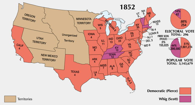
파일:ElectoralCollege1852-Large.png

미리 보기 크기: 800 × 430 픽셀 다른 해상도: 320 × 172 픽셀 | 640 × 344 픽셀 | 1,182 × 635 픽셀
원본 파일 (1,182 × 635 픽셀, 파일 크기: 93 KB, MIME 종류: image/png)

|
이 그림은 벡터 그래픽 버전(SVG)이 있습니다. 래스터(비트맵) 그림 대신 벡터 그래픽 그림을 사용하는 것이 좋습니다.
File:ElectoralCollege1852-Large.png → File:1852 US Electoral Map.svg
|
 |
| 설명 |
|
||||
| 출처 | National Atlas of the United States | ||||
| 저자 | Uploaded by Hephaestos | ||||
| 저작권 (이 파일을 인용하기) |
|
||||
| 다른 버전 |
|


| History | |||||||||||||||
|---|---|---|---|---|---|---|---|---|---|---|---|---|---|---|---|
기존 올리기 기록Legend: (cur) = this is the current file, (del) = delete this old version, (rev) = revert to this old version. Click on date to download the file or see the image uploaded on that date.
|
파일 역사
날짜/시간 링크를 클릭하면 해당 시간의 파일을 볼 수 있습니다.
| 날짜/시간 | 섬네일 | 크기 | 사용자 | 설명 | |
|---|---|---|---|---|---|
| 현재 | 2006년 1월 22일 (일) 23:11 | | 1,182 × 635 (93 KB) | Maksim | La bildo estas kopiita de wikipedia:en. La originala priskribo estas: {{PD-USGov-Atlas}} Category:Historical maps of the United States {| border="1" ! date/time || username || edit summary |---- | 01:22, 22 January 2006 || en:User:DLJessup || |
이 파일을 사용하는 문서
다음 문서 1개가 이 파일을 사용하고 있습니다:
이 파일을 사용하고 있는 모든 위키의 문서 목록
다음 위키에서 이 파일을 사용하고 있습니다:
- eo.wikipedia.org에서 이 파일을 사용하고 있는 문서 목록
- it.wikipedia.org에서 이 파일을 사용하고 있는 문서 목록
- ja.wikipedia.org에서 이 파일을 사용하고 있는 문서 목록
- uk.wikipedia.org에서 이 파일을 사용하고 있는 문서 목록