
파일:Etna eruption seen from the International Space Station.jpg
미리 보기 크기: 800 × 588 픽셀 다른 해상도: 320 × 235 픽셀 | 640 × 471 픽셀 | 1,024 × 753 픽셀 | 1,280 × 941 픽셀 | 2,720 × 2,000 픽셀
원본 파일 (2,720 × 2,000 픽셀, 파일 크기: 1.02 MB, MIME 종류: image/jpeg)
파일 설명
| 설명 |
Deutsch: Ausbruch des Ätna am 30. Oktober 2002, fotografiert von der Internationalen Raumstation ISS. Dieses Bild zeigt eine Detailaufnahme des Vulkanausbruchs, währenddem ein zweites von der ISS aufgenommenes Bild die weiträumigen Auswirkungen (Aschewolke) aufzeigt.
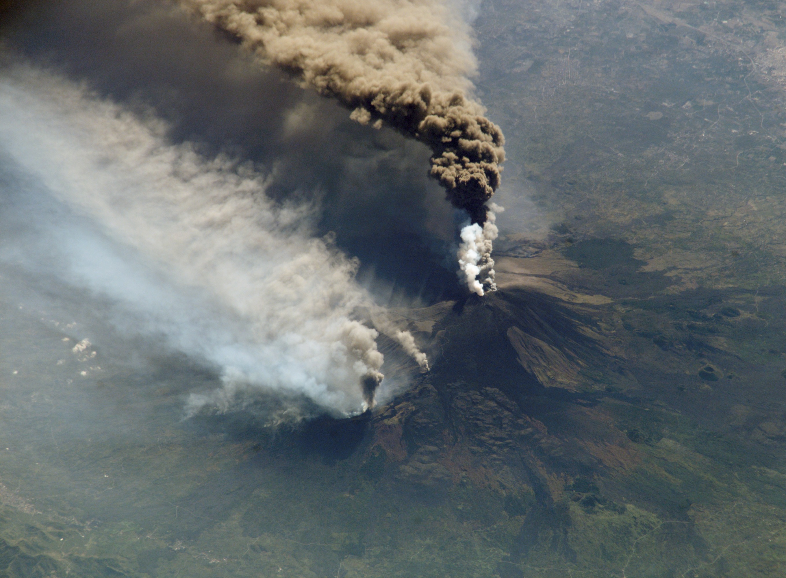
English: ISS005-E-19024 --- The three-member crew of the Expedition Five mission onboard the International Space Station was able to observe Mt. Etna’s spectacular eruption, and photograph the details of the eruption plume and smoke from fires triggered by the lava as it flowed down the 11,000 ft mountain. This image and a second image (ISS005-E-19016) are looking obliquely to the southeast over the island of Sicily. This wider view (ISS005-E-19024) shows the ash plume curving out toward the horizon, caught first by low-level winds blowing to the southeast, and to the south toward Africa at higher altitudes. Ashfall was reported in Libya, more than 350 miles away. The lighter-colored plumes downslope and north of the summit seen in this frame are produced by forest fires set by lava flowing into the pine forests on the slope of the mountain. This image provides a more three-dimensional profile of the eruption plume. This eruption was one of Etna’s most vigorous in years, volcanologists reported this week. The eruption was triggered by a series of earthquakes on October 27, 2002, they said. These images were taken on October 30. Although schools were closed and air traffic was diverted because of the ash, no towns or villages were reported to have been threatened by the lava flow.
Español: Erupción del Etna del 30 de octubre de 2002, fotografiada desde la Estación Espacial Internacional. Se puede distinguir la columna eruptiva emitida desde el cráter de la cumbre, así como los incendios causados por los flujos de lava en las laderas del volcán. Las cenizas de la columna eruptiva fueron llevados hacia el sureste por los vientos de baja altitud y luego hacia el sur a mayor altitud. Las cenizas cayeron sobre Libia, a más de 500 km de distancia. La erupción de 2002 fue una de las más grandes del Etna en los últimos años. No obstante, ningún pueblo fue destruido por los flujos de lava.
Français : Éruption de l'Etna du 30 octobre 2002, photographiée depuis la Station spatiale internationale. On peut voir le panache éruptif émis par le cratère sommital, ainsi que des incendies causés par des coulées de lave en contrebas. Les poussières du panache sont charriées vers le sud-est par les vents de basse altitudes puis plein sud à plus haute altitude. Des cendres sont ainsi tombées sur la Libye, à plus de 500 km de distance. L'éruption de 2002 est l'une des plus vigoureuses éruptions de l'Etna ces dernières années. Aucun village n'a cependant été détruit par les coulées de lave.
Українська: Виверження Етни 30 жовтня 2002 року, сфотографоване з Міжнародної космічної станції, Сицилія, Італія. Внизу видно шлейф, який викидає кратер на вершині, а також пожежі, спричинені потоками лави. Пил від шлейфу розноситься на південний схід вітрами низької висоти, а потім на південь на більшій висоті. Таким чином попіл досяг Лівії, яка знаходилася на відстані більше як 500 км. Виверження 2002 року - одне з найсильніших вивержень Етни за останні роки. Однак жоден населенний пункт не було зруйноване потоками лави. |
||
| 날짜 | |||
| 출처 | http://spaceflight.nasa.gov/gallery/images/station/crew-5/html/iss005e19024.html or http://earth.jsc.nasa.gov/newsletter/PhotographyfromISS/ISS005-E-19024.htm | ||
| 저자 | NASA | ||
| 저작권 (이 파일을 인용하기) |
|
| 카메라 위치 | | 이 지역의 다른 사진을 보기: OpenStreetMap |
|---|
수상
|

이 이미지는 2022년 10월 30일의 오늘의 이미지로 선정되었습니다. 이미지 설명은 다음과 같습니다. English: Eruption of Mount Etna in Sicily, Italy seen from the International Space Station on 30 October 2002. 다른 언어들:
Čeština: Výbuch sopky Etny na Sicílii dne 30. října 2002 ze záznamů kamer Mezinárodní vesmírné stanice (ISS). Deutsch: Ausbruch des Ätna in Sizilien, fotografiert von der Internationalen Raumstation am 30. Oktober 2002. English: Eruption of Mount Etna in Sicily, Italy seen from the International Space Station on 30 October 2002. Español: Erupción del Etna del 30 de octubre de 2002, fotografiada desde la Estación Espacial Internacional. Français : Éruption de l'Etna en Sicile (Italie) vue depuis la Station spatiale internationale le 30 octobre 2002. Nederlands: Eruptie van de Etna op het Italiaanse eiland Sicilië, gefotografeerd op 30 oktober 2002 vanuit het ISS Português: Erupção do Etna na Sicília, Itália, vista da Estação Espacial Internacional em 30 de outubro de 2002. Slovenščina: Izbruh ognjenika Etna na Siciliji, Italija, kot se je videl iz Mednarodne vesoljske postaje 30. oktobra 2002 Македонски: Избув на вулканот Етна на Сицилија, сликан од Меѓународната вселенска станица на 30 октомври 2002 г. Українська: Виверження Етни 30 жовтня 2002 року, сфотографоване з Міжнародної космічної станції, Італія. |
| Open this image as an overlay in Google Earth (Google Maps, Bing) | (Help|Source) |
This image or video was catalogued by one of the centers of the United States National Aeronautics and Space Administration (NASA) under Photo ID: ISS005-E-19024. This tag does not indicate the copyright status of the attached work. A normal copyright tag is still required. See Commons:Licensing. Other languages:
|
파일 역사
날짜/시간 링크를 클릭하면 해당 시간의 파일을 볼 수 있습니다.
| 날짜/시간 | 섬네일 | 크기 | 사용자 | 설명 | |
|---|---|---|---|---|---|
| 현재 | 2006년 12월 19일 (화) 00:14 | | 2,720 × 2,000 (1.02 MB) | Bricktop | full resolution |
| 2005년 10월 28일 (금) 21:27 |  | 1,000 × 760 (183 KB) | Los688 | From en:Image:Etna eruption seen from the International Space Station.jpg Etna's 2002 eruption, photographed from the International Space Station. {{PD-USGov-NASA}} |
이 파일을 사용하는 문서
다음 문서 1개가 이 파일을 사용하고 있습니다:
이 파일을 사용하고 있는 모든 위키의 문서 목록
다음 위키에서 이 파일을 사용하고 있습니다:
- af.wikipedia.org에서 이 파일을 사용하고 있는 문서 목록
- als.wikipedia.org에서 이 파일을 사용하고 있는 문서 목록
- alt.wikipedia.org에서 이 파일을 사용하고 있는 문서 목록
- ar.wikipedia.org에서 이 파일을 사용하고 있는 문서 목록
- arz.wikipedia.org에서 이 파일을 사용하고 있는 문서 목록
- av.wikipedia.org에서 이 파일을 사용하고 있는 문서 목록
- ban.wikipedia.org에서 이 파일을 사용하고 있는 문서 목록
- ba.wikipedia.org에서 이 파일을 사용하고 있는 문서 목록
- bg.wikipedia.org에서 이 파일을 사용하고 있는 문서 목록
- bn.wikipedia.org에서 이 파일을 사용하고 있는 문서 목록
- bo.wikipedia.org에서 이 파일을 사용하고 있는 문서 목록
- bs.wikipedia.org에서 이 파일을 사용하고 있는 문서 목록
- ca.wikipedia.org에서 이 파일을 사용하고 있는 문서 목록
- ceb.wikipedia.org에서 이 파일을 사용하고 있는 문서 목록
- ce.wikipedia.org에서 이 파일을 사용하고 있는 문서 목록
- cs.wikipedia.org에서 이 파일을 사용하고 있는 문서 목록
- cv.wikipedia.org에서 이 파일을 사용하고 있는 문서 목록
- cy.wikipedia.org에서 이 파일을 사용하고 있는 문서 목록
- da.wikipedia.org에서 이 파일을 사용하고 있는 문서 목록
- de.wikipedia.org에서 이 파일을 사용하고 있는 문서 목록
- Sizilien
- Ätna
- Mittelmeerraum
- Portal:Italien
- Italien
- Portal:Sizilien
- Portal Diskussion:Geographie/Bild des Monats
- Portal:Sizilien/Prämiertes
- Portal:Sizilien/Prämiertes/Bilder
- Portal:Italien/Prämiertes
- Portal:Italien/Prämiertes/Bilder
- Geographie Europas
- Wikipedia:Exzellente Bilder/Landschaften
- Wikipedia:Kandidaten für exzellente Bilder/Archiv2008/26
- Datei:Etna eruption seen from the International Space Station.jpg
- Portal Diskussion:Vulkane/Vulkanbild der Woche
이 파일의 더 많은 사용 내역을 봅니다.