
파일:Extent of the Hansa.png

미리 보기 크기: 800 × 445 픽셀 다른 해상도: 320 × 178 픽셀 | 640 × 356 픽셀 | 1,250 × 695 픽셀
원본 파일 (1,250 × 695 픽셀, 파일 크기: 141 KB, MIME 종류: image/png)
| 설명 |
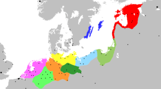
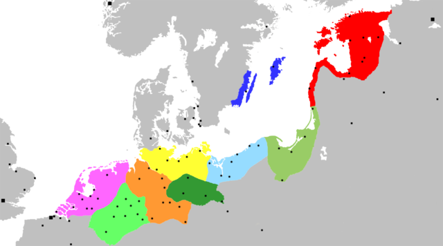
Map of the Hanseatic League, circa 1400, showing Circles, Kontore and principal Hanseatic cities Netherlands Circle
Westphalian Circle
Saxon Circle
Wendish Circle
Margravian Circle
Pomeranian Circle
Prussian Circle
Livonian Circle
Swedish Circle
Squares indicate Kontore; dots indicate Hanseatic cities. |
||
| 날짜 | (UTC) | ||
| 출처 | Adapted from Image:Extent of the Hansa.jpg, itself in the public domain because its first publication occurred in 1902 — prior to January 1, 1923 | ||
| 저자 | OwenBlacker | ||
| 저작권 (이 파일을 인용하기) |
|
||
| 다른 버전 | Image:Extent of the Hansa.jpg |
파일 역사
날짜/시간 링크를 클릭하면 해당 시간의 파일을 볼 수 있습니다.
| 날짜/시간 | 섬네일 | 크기 | 사용자 | 설명 | |
|---|---|---|---|---|---|
| 현재 | 2007년 11월 20일 (화) 09:12 | | 1,250 × 695 (141 KB) | OwenBlacker | {{Information |Description= Map of the Hanseatic League, circa 1400, showing Circles, ''Kontore'' and principal Hanseatic cities |Source= Adapted from Image:Extent of the Hansa.jpg |Date=~~~~~ |Author=~~~ |Permission={{PD-self}} |other_versio |
이 파일을 사용하는 문서
다음 문서 1개가 이 파일을 사용하고 있습니다:
이 파일을 사용하고 있는 모든 위키의 문서 목록
다음 위키에서 이 파일을 사용하고 있습니다:
- af.wikipedia.org에서 이 파일을 사용하고 있는 문서 목록
- ar.wikipedia.org에서 이 파일을 사용하고 있는 문서 목록
- برلين
- تالين
- هامبورغ
- ستوكهولم
- ريغا
- لندن
- براونشفايغ (مدينة)
- كولونيا
- بريمن
- ماغديبورغ
- الرابطة الهانزية
- نيوكاسل أبون تاين
- إبسوتش
- روستوك
- بوخوم
- دورتموند
- مونستر
- دويسبورغ
- شتاده
- لونبورغ
- ستارغارد
- كيل
- كراكوف
- فروتسواف
- برغن
- لوبيك
- كالينينغراد
- بيتيرهوف
- بسكوف
- فيليكي نوفغورود
- إرفورت
- كينغستون أبون هال
- أنتويرب
- بروج
- يورك
- كاوناس
- تارتو
- بوسطن (إنجلترا)
- أوسنابروك
- تورون
- هام (مدينة)
- غدانسك
- مولهاوزن (تورينغيا)
- هاله (سكسونيا-أنهالت)
- قالب:الرابطة الهانزية
- فيسبي
- هاردرفايك
- كونيغسبرغ
- خرننغن
이 파일의 더 많은 사용 내역을 봅니다.