
파일:Florida counties map.png

미리 보기 크기: 617 × 600 픽셀 다른 해상도: 247 × 240 픽셀 | 494 × 480 픽셀 | 865 × 841 픽셀
원본 파일 (865 × 841 픽셀, 파일 크기: 102 KB, MIME 종류: image/png)
파일 설명
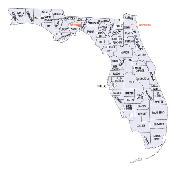
| 설명 | Map of Florida's counties. Transwiki approved by: w:en:User:Dmcdevit |
| 날짜 | 24 June 2005 (upload) |
| 출처 | Florida QuickFacts. US Census Bureau. Archived from the original on 23 June 2005. |
| 저자 | United States Census Bureau |
라이선스
This image or file is a work of a United States Census Bureau employee, taken or made as part of that person's official duties. As a work of the U.S. federal government, the image is in the public domain.
|
 |
기존 올리기 기록
| date/time | username | resolution | size | edit summary |
|---|---|---|---|---|
| 22:40, 24 June 2005 | w:en:User:Jengod | 865×841 | 102 KB | <a href="/wiki/Category:Florida_maps" title="Category:Florida maps">Category:Florida maps</a> {{PD-USGov-DOC-Census}} |
Image description page history
| link | date/time | username | edit summary |
|---|---|---|---|
| http://en.wikipedia.org/w/index.php?title=Image:Florida_counties_map.png&redirect=no&oldid=17718338 | 08:04, 16 September 2007 | w:en:User:Dmcdevit | |
| http://en.wikipedia.org/w/index.php?title=Image:Florida_counties_map.png&redirect=no&oldid=17718338 | 22:40, 24 June 2005 | w:en:User:Jengod | (<a href="/wiki/Category:Florida_maps" title="Category:Florida maps">Category:Florida maps</a> {{PD-USGov-DOC-Census}}) |
파일 역사
날짜/시간 링크를 클릭하면 해당 시간의 파일을 볼 수 있습니다.
| 날짜/시간 | 섬네일 | 크기 | 사용자 | 설명 | |
|---|---|---|---|---|---|
| 현재 | 2007년 9월 16일 (일) 22:33 | | 865 × 841 (102 KB) | BetacommandBot | Transwiki approved by: w:en:User:Dmcdevit This image was copied from wikipedia:en. The original description was: w:en:Category:Florida maps {{PD-USGov-DOC-Census}} === File history === {| class=wikitable ! date/time || username || resolution | |
이 파일을 사용하는 문서
다음 문서 1개가 이 파일을 사용하고 있습니다:
이 파일을 사용하고 있는 모든 위키의 문서 목록
다음 위키에서 이 파일을 사용하고 있습니다:
- cy.wikipedia.org에서 이 파일을 사용하고 있는 문서 목록
- de.wikipedia.org에서 이 파일을 사용하고 있는 문서 목록
- en.wikipedia.org에서 이 파일을 사용하고 있는 문서 목록
- frr.wikipedia.org에서 이 파일을 사용하고 있는 문서 목록
- fr.wikipedia.org에서 이 파일을 사용하고 있는 문서 목록
- hi.wikipedia.org에서 이 파일을 사용하고 있는 문서 목록
- id.wikipedia.org에서 이 파일을 사용하고 있는 문서 목록
- ja.wikipedia.org에서 이 파일을 사용하고 있는 문서 목록
- mk.wikipedia.org에서 이 파일을 사용하고 있는 문서 목록
- new.wikipedia.org에서 이 파일을 사용하고 있는 문서 목록
- nl.wikipedia.org에서 이 파일을 사용하고 있는 문서 목록
- pt.wikipedia.org에서 이 파일을 사용하고 있는 문서 목록
- ro.wikipedia.org에서 이 파일을 사용하고 있는 문서 목록
- ru.wikipedia.org에서 이 파일을 사용하고 있는 문서 목록
- sv.wikipedia.org에서 이 파일을 사용하고 있는 문서 목록
- zh.wikipedia.org에서 이 파일을 사용하고 있는 문서 목록