
파일:GreeceNaturalGasPipelinesApproximation.png
최대 해상도입니다.
GreeceNaturalGasPipelinesApproximation.png (496 × 496 픽셀, 파일 크기: 194 KB, MIME 종류: image/png)
| 설명 |
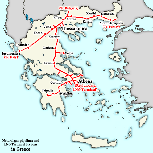
English: A map showing the approximate locations of natural gas pipelines in Greece]]: they run approximately from Alexandroupolis to Thessaloniki and then fork into two directions, one going towards Igoumenitsa (and later Italy) and the other towards Larissa, Lamia, Thiva, Athens, Corinth, Nauplio, and Tripolis. Note: this map also shows the planned Greece-Italy pipeline from Thessaloniki to Igoumenitsa which is not built yet. Greece maintains a powerful energy industry with particular emphasis on natural gas, managed by the DEPA company. This map is an approximation of the natural gas pipelines in Greece, based on information available from http://www.depa.gr/files/downloadables/national-map-gr.pdf
Ελληνικά: Ένας χάρτης που δείχνει στο περίπου τις τοποθεσίες αγωγών φυσικού αερίου της Ελλάδος: τρέχουν από Αλεξανδρούπολη προς Θεσσαλονικη και μετά χωρίζονται σε δυο δρόμους, ένα προς Ιγουμενίτσα (και τελικά Ιταλία) και τον άλλο προς Λάρισα, Λαμία, Θήβα, Αθήνα, Κόρινθος, και Τρίπολη. Σημείωση: ο χάρτης δείχνει και τον αγωγό Ιταλίας-Ελλάδας από Θεσσαλονίκη έως Ιγουμενίτσα που δεν έχει χτιστεί ακόμη. Η Ελλάδα διαθέτει μία παντοδύναμη ενεργειακή οικονομία με ιδιαίτερη έμφαση στο φυσικό αέριο, το οποίο τελεί υπό την διαχείρηση της εταιρείας ΔΕΠΑ. Αυτός ο χάρτης είναι μία ανακριβή απεικόνιση των σωλήνων φυσικού αερίου της Ελλάδος, βασισμένος σε πληροφορίες που υπάρχουν στο http://www.depa.gr/files/downloadables/national-map-gr.pdf |
| 날짜 | |
| 출처 | Derivative work based on http://commons.wikimedia.org/wiki/File:Greece_outline_map.png |
| 저자 | This derivative work is from NSK Nikolaos S. Karastathis (User:NSK Nikolaos S. Karastathis); the original work upon this derivative work is based on was originally uploaded by ChrisO at en.wikipedia ( http://en.wikipedia.org/wiki/User:ChrisO ) and it was later uploaded on Wikimedia Commons by Sasa_Stefanovic ( http://commons.wikimedia.org/wiki/User:Sasa_Stefanovic ) |
| 저작권 (이 파일을 인용하기) |
GFDL |
| 다른 버전 | http://commons.wikimedia.org/wiki/File:Greece_outline_map.png |
The original map was released under the GFDL by the author ChrisO at en.wikipedia ( http://en.wikipedia.org/wiki/User:ChrisO ) (Released under the GNU Free Documentation License). This derivative work, therefore, is also released under the same licence, the GFDL (Released under the GNU Free Documentation License).
[[:c:User:{{{1}}}|{{{1}}}]]은(는) 아래 작품의 저작권자로서, 해당 저작물을 다음과 같은 라이선스로 배포합니다:

|
GNU 자유 문서 사용 허가서 1.2판 또는 자유 소프트웨어 재단에서 발행한 이후 판의 규정에 따라 본 문서를 복제하거나 개작 및 배포할 수 있습니다. 본 문서에는 변경 불가 부분이 없으며, 앞 표지 구절과 뒷 표지 구절도 없습니다. 본 사용 허가서의 전체 내용은 GNU 자유 문서 사용 허가서 부분에 포함되어 있습니다. |
| 이 파일은 크리에이티브 커먼즈 저작자표시-동일조건변경허락 3.0 Unported 라이선스로 배포됩니다. | ||
| 저작자표시: [[:c:User:{{{1}}}|{{{1}}}]] | ||
| ||
| 이 라이선스 틀은 GFDL 라이선스 변경의 일부로 이 파일에 추가되었습니다. |
파일 역사
날짜/시간 링크를 클릭하면 해당 시간의 파일을 볼 수 있습니다.
| 날짜/시간 | 섬네일 | 크기 | 사용자 | 설명 | |
|---|---|---|---|---|---|
| 현재 | 2015년 12월 7일 (월) 23:22 | | 496 × 496 (194 KB) | SilentResident | Improved and updated |
| 2009년 1월 20일 (화) 03:01 |  | 800 × 700 (45 KB) | NSK Nikolaos S. Karastathis | {{Information |Description={{en|1=Greece maintains a powerful energy industry with particular emphasis on natural gas, managed by the DEPA company. This map is an approximation of the natural gas pipelines in Greece, based on information available from h |
이 파일을 사용하는 문서
다음 문서 1개가 이 파일을 사용하고 있습니다:
이 파일을 사용하고 있는 모든 위키의 문서 목록
다음 위키에서 이 파일을 사용하고 있습니다:
- bg.wikipedia.org에서 이 파일을 사용하고 있는 문서 목록
- el.wikipedia.org에서 이 파일을 사용하고 있는 문서 목록
- en.wikipedia.org에서 이 파일을 사용하고 있는 문서 목록
- es.wikipedia.org에서 이 파일을 사용하고 있는 문서 목록
- fr.wikipedia.org에서 이 파일을 사용하고 있는 문서 목록
- he.wikipedia.org에서 이 파일을 사용하고 있는 문서 목록
- it.wikipedia.org에서 이 파일을 사용하고 있는 문서 목록
- ru.wikipedia.org에서 이 파일을 사용하고 있는 문서 목록
- tr.wikipedia.org에서 이 파일을 사용하고 있는 문서 목록
- uz.wikipedia.org에서 이 파일을 사용하고 있는 문서 목록