
파일:Gulf of Saint Lawrence.jpg
최대 해상도입니다.
Gulf_of_Saint_Lawrence.jpg (734 × 456 픽셀, 파일 크기: 99 KB, MIME 종류: image/jpeg)
파일 설명
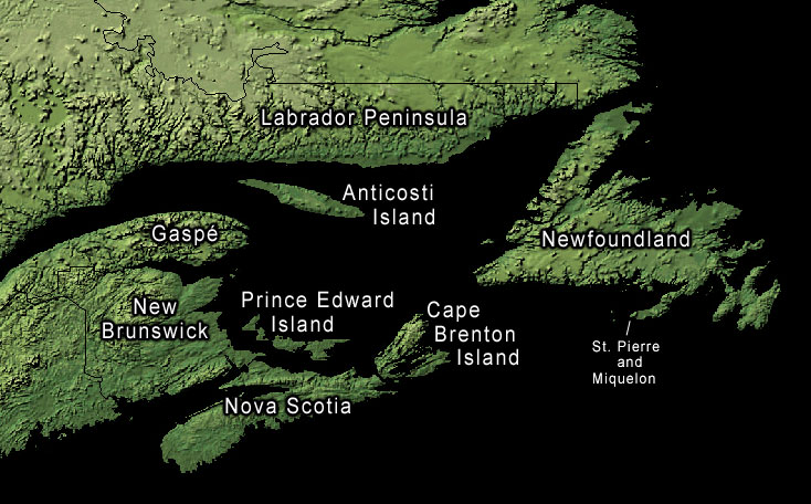
Land-cover imagery from USGS's National Map Server archive copy at the Wayback Machine. Photoshop file with layers is located here in case any modifications or translations are needed.
라이선스
이 파일은 미국 법전 제17편 제1장 제105조에 따른 미국 연방정부의 공무원 또는 피고용인이 공무상 작성한 저작물로, 미국에서 퍼블릭 도메인입니다.
주의: 본 라이선스는 미국 연방정부의 저작물에 관해서만 효력이 있습니다. 미국의 주, 군, 기타 지방자치단체가 만든 저작물에 대해서는 적용되지 않습니다. 또한 미국 우정청이 1978년부터 발행한 우표 디자인에도 적용되지 않습니다.
|
 | |
| 이 저작물은 모든 저작인접권을 포함한 저작권법하의 규제로부터 자유로운 것으로 확인되었습니다. | ||
기존 올리기 기록
The original description page was here. All following user names refer to en.wikipedia.
- 2006-01-30 20:43 Kelisi 734×456× (74652 bytes) same, with spelling correction
- 2005-10-23 17:10 Interiot 734×456× (101750 bytes) inc font size of "Gaspé"
- 2005-10-23 15:38 Interiot 734×456× (101801 bytes) more font tweaks
- 2005-10-23 15:32 Interiot 734×457× (101689 bytes) larger font
- 2005-10-23 15:26 Interiot 781×481× (111492 bytes) Map of the [[Gulf of Saint Lawrence]]. Land-cover imagery from [[USGS]]'s [http://nmviewogc.cr.usgs.gov/viewer.htm National Map Server].
파일 역사
날짜/시간 링크를 클릭하면 해당 시간의 파일을 볼 수 있습니다.
| 날짜/시간 | 섬네일 | 크기 | 사용자 | 설명 | |
|---|---|---|---|---|---|
| 현재 | 2012년 9월 18일 (화) 07:23 | | 734 × 456 (99 KB) | OgreBot | (BOT): Reverting to most recent version before archival |
| 2012년 9월 18일 (화) 07:23 |  | 734 × 456 (73 KB) | OgreBot | (BOT): Uploading old version of file from en.wikipedia; originally uploaded on 2006-01-30 20:43:20 by Kelisi | |
| 2012년 9월 18일 (화) 07:23 |  | 734 × 456 (99 KB) | OgreBot | (BOT): Uploading old version of file from en.wikipedia; originally uploaded on 2005-10-23 15:38:39 by Interiot | |
| 2012년 9월 18일 (화) 07:23 |  | 734 × 457 (99 KB) | OgreBot | (BOT): Uploading old version of file from en.wikipedia; originally uploaded on 2005-10-23 15:32:33 by Interiot | |
| 2012년 9월 18일 (화) 07:23 |  | 781 × 481 (109 KB) | OgreBot | (BOT): Uploading old version of file from en.wikipedia; originally uploaded on 2005-10-23 15:26:46 by Interiot | |
| 2006년 1월 29일 (일) 17:05 |  | 734 × 456 (99 KB) | Kpjas | Land-cover imagery from USGS's [http://nmviewogc.cr.usgs.gov/viewer.htm National Map Server]. Photoshop file with layers is located [http://paperlined.org/apps/wikipedia/src_data/Gulf_of_Saint_Lawrence.psd here] in case any modifications or trans |
이 파일을 사용하는 문서
이 파일을 사용하고 있는 모든 위키의 문서 목록
다음 위키에서 이 파일을 사용하고 있습니다:
- af.wikipedia.org에서 이 파일을 사용하고 있는 문서 목록
- az.wikipedia.org에서 이 파일을 사용하고 있는 문서 목록
- ba.wikipedia.org에서 이 파일을 사용하고 있는 문서 목록
- be.wikipedia.org에서 이 파일을 사용하고 있는 문서 목록
- bs.wikipedia.org에서 이 파일을 사용하고 있는 문서 목록
- ce.wikipedia.org에서 이 파일을 사용하고 있는 문서 목록
- cs.wikipedia.org에서 이 파일을 사용하고 있는 문서 목록
- el.wikipedia.org에서 이 파일을 사용하고 있는 문서 목록
- en.wikipedia.org에서 이 파일을 사용하고 있는 문서 목록
- fa.wikipedia.org에서 이 파일을 사용하고 있는 문서 목록
- fr.wikipedia.org에서 이 파일을 사용하고 있는 문서 목록
- he.wikipedia.org에서 이 파일을 사용하고 있는 문서 목록
- id.wikipedia.org에서 이 파일을 사용하고 있는 문서 목록
- it.wikipedia.org에서 이 파일을 사용하고 있는 문서 목록
- lv.wikipedia.org에서 이 파일을 사용하고 있는 문서 목록
- pl.wikipedia.org에서 이 파일을 사용하고 있는 문서 목록
- ro.wikipedia.org에서 이 파일을 사용하고 있는 문서 목록
- ru.wikipedia.org에서 이 파일을 사용하고 있는 문서 목록
- sh.wikipedia.org에서 이 파일을 사용하고 있는 문서 목록
- sk.wikipedia.org에서 이 파일을 사용하고 있는 문서 목록
- sr.wikipedia.org에서 이 파일을 사용하고 있는 문서 목록
- uk.wikipedia.org에서 이 파일을 사용하고 있는 문서 목록
- zh.wikipedia.org에서 이 파일을 사용하고 있는 문서 목록