
파일:Hundred years war.gif

미리 보기 크기: 522 × 599 픽셀 다른 해상도: 209 × 240 픽셀 | 541 × 621 픽셀
원본 파일 (541 × 621 픽셀, 파일 크기: 140 KB, MIME 종류: image/gif, 반복됨, 10 프레임, 35 s)
파일 설명
| 설명 |
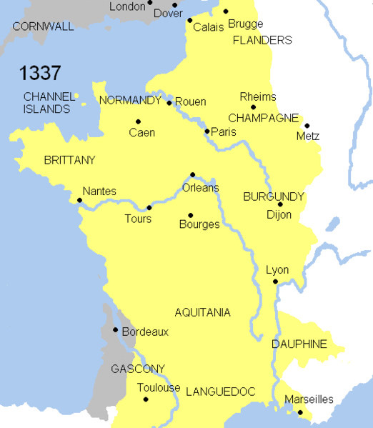
English: Animated map Hundred years war. This map shows the war`s evolution and the most important battles.
Displayed in the map: France
England
Burgundy
Battles-Battle of Crecy (1346), Battle of Poitiers (1356), Battle of Agincourt (1415), Battle of Castillon (1429), Battle of Formigny (1450)
Years shown: 1337, 1346, 1356, 1360, 1415, 1429, 1429-31, 1450, 1451-53, 1453. |
| 날짜 | |
| 출처 | |
| 저자 | Andrein (d) |
라이선스
| 이 작품은 저작자인 Andrein에 의해 퍼블릭 도메인으로 공개된 작품입니다. 이 공개 선언은 전 세계적으로 유효합니다. 만약 저작권의 포기가 법률적으로 가능하지 않은 경우, |

|
This map has been uploaded by Electionworld from en.wikipedia.org to enable the |
파일 역사
날짜/시간 링크를 클릭하면 해당 시간의 파일을 볼 수 있습니다.
| 날짜/시간 | 섬네일 | 크기 | 사용자 | 설명 | |
|---|---|---|---|---|---|
| 현재 | 2008년 7월 21일 (월) 17:37 | | 541 × 621 (140 KB) | Chphe | without watermark |
| 2007년 3월 17일 (토) 21:23 |  | 541 × 621 (139 KB) | Electionworld | == Licensing == {{PD-self}} {{ew|en|Andrei Nacu}} Category:Maps of the history of France == File History in Wikipedia== Legend: (cur) = this is the current file, (del) = delete this old version, (rev) = revert to this old version. Click on date to do |
이 파일을 사용하는 문서
다음 문서 1개가 이 파일을 사용하고 있습니다:
이 파일을 사용하고 있는 모든 위키의 문서 목록
다음 위키에서 이 파일을 사용하고 있습니다:
- am.wikipedia.org에서 이 파일을 사용하고 있는 문서 목록
- azb.wikipedia.org에서 이 파일을 사용하고 있는 문서 목록
- az.wikipedia.org에서 이 파일을 사용하고 있는 문서 목록
- ba.wikipedia.org에서 이 파일을 사용하고 있는 문서 목록
- be.wikipedia.org에서 이 파일을 사용하고 있는 문서 목록
- bg.wikipedia.org에서 이 파일을 사용하고 있는 문서 목록
- bn.wikipedia.org에서 이 파일을 사용하고 있는 문서 목록
- bn.wikibooks.org에서 이 파일을 사용하고 있는 문서 목록
- ca.wikipedia.org에서 이 파일을 사용하고 있는 문서 목록
- crh.wikipedia.org에서 이 파일을 사용하고 있는 문서 목록
- cs.wikipedia.org에서 이 파일을 사용하고 있는 문서 목록
- cy.wikipedia.org에서 이 파일을 사용하고 있는 문서 목록
- diq.wikipedia.org에서 이 파일을 사용하고 있는 문서 목록
- en.wikipedia.org에서 이 파일을 사용하고 있는 문서 목록
- en.wikibooks.org에서 이 파일을 사용하고 있는 문서 목록
- eo.wikipedia.org에서 이 파일을 사용하고 있는 문서 목록
- es.wikipedia.org에서 이 파일을 사용하고 있는 문서 목록
- et.wikipedia.org에서 이 파일을 사용하고 있는 문서 목록
- fa.wikipedia.org에서 이 파일을 사용하고 있는 문서 목록
- fr.wikipedia.org에서 이 파일을 사용하고 있는 문서 목록
- ga.wikipedia.org에서 이 파일을 사용하고 있는 문서 목록
- he.wikipedia.org에서 이 파일을 사용하고 있는 문서 목록
- hif.wikipedia.org에서 이 파일을 사용하고 있는 문서 목록
- hu.wikipedia.org에서 이 파일을 사용하고 있는 문서 목록
- id.wikibooks.org에서 이 파일을 사용하고 있는 문서 목록
- is.wikipedia.org에서 이 파일을 사용하고 있는 문서 목록
이 파일의 더 많은 사용 내역을 봅니다.