
파일:Isaac 2012-08-28 1630Z.jpg

원본 파일 (6,468 × 7,900 픽셀, 파일 크기: 24.67 MB, MIME 종류: image/jpeg)
파일 설명
| 설명 |
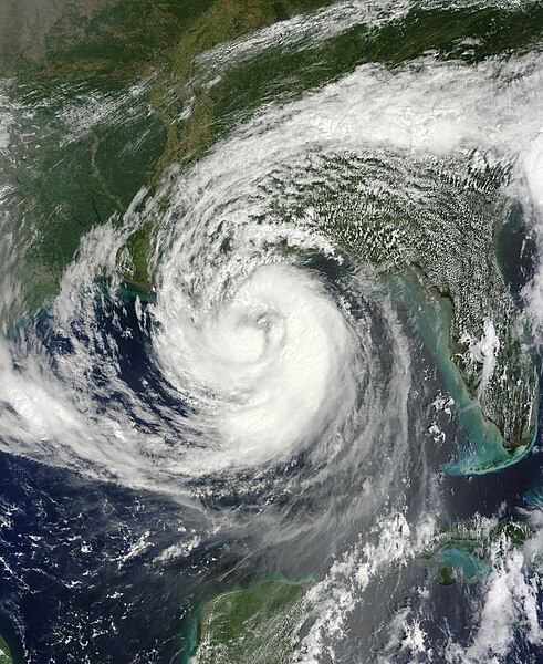
English: On August 28, 2012, tropical storm Isaac achieved hurricane force and was predicted to make landfall on the Gulf Coast of the United States sometime overnight. A category 1 storm, Hurricane Isaac approached the Louisiana and Mississippi coasts on the seventh anniversary of Hurricane Katrina. Hurricane watches and warnings were posted from Intracoastal City, Louisiana, to the Mississippi-Alabama border.
The Moderate Resolution Imaging Spectroradiometer (MODIS) on NASA’s Terra satellite captured this image of Isaac in the Gulf of Mexico at 11:30 a.m. Central Daylight Time (16:30 Universal Time) on August 28, 2012. Researchers working with the Suomi-NPP satellite also captured this nighttime view of the storm from earlier today. At 1 p.m. CDT on August 28, forecasters at the National Hurricane Center (NHC) reported that Isaac was centered at 28.4° North latitude and 88.7° West longitude, about 135 miles (220 kilometers) south of New Orleans. The storm was moving northwestward toward the mouth of the Mississippi River at 10 miles (17 kilometers) per hour, with maximum sustained winds of 75 miles (120 kilometers) per hour. Hurricane-force winds extended 60 miles (96 kilometers) from the center. NHC forecasters expected Isaac to strengthen a bit before reaching shore, and warned of potential flooding from rainfall of 7 to 14 inches (18 to 36 centimeters), with localized precipitation up to 20 inches (50 centimeters). They also warned of a storm surge that could reach 6 to 12 feet (2 to 3.5 meters), depending on the timing of landfall and of local tides. Though just a category 1 storm, Isaac’s slow forward motion had the potential to pile up more water in the storm surge. Winds and storm surges are worst on the right/northeastern side of hurricanes. The five-day forecast suggested that the hurricane and its remnants would head straight up the Mississippi River basin and perhaps to the Ohio River—potentially offering some relief in areas where the river has been exceptionally low. But the heavy rains could also provoke severe flooding, as the parched ground and dried up crops will not necessarily absorb that much water. NASA is just days from launching an intensive multi-year study of hurricane formation and evolution in the Atlantic Ocean. Known as the Hurricane and Severe Storm Sentinel (HS3) mission, the project will use robotic Global Hawk airplanes to fly over and through storm systems. A principal goal is to learn more about what makes tropical storms intensify into hurricanes. |
| 날짜 | |
| 출처 | http://lance-modis.eosdis.nasa.gov/wms/?zoom=4&lat=28.60547&lon=-64.875&layers=B0000FFFFT&datum1=08/28/2012 |
| 저자 | LANCE/EOSDIS Rapid Response. Caption by Michael Carlowicz. |
라이선스
| 이 파일은 NASA에서 제작하였으므로 퍼블릭 도메인입니다. NASA의 저작권 정책에 따르면 NASA의 자료는 명시하지 않는 이상 저작권의 보호를 받지 않습니다. (Template:PD-USGov, 또는 NASA 저작권 정책 문서, JPL 그림 사용 정책을 참고하세요.) | ||
 |
주의사항:
|
파일 역사
날짜/시간 링크를 클릭하면 해당 시간의 파일을 볼 수 있습니다.
| 날짜/시간 | 섬네일 | 크기 | 사용자 | 설명 | |
|---|---|---|---|---|---|
| 현재 | 2013년 1월 8일 (화) 08:45 | | 6,468 × 7,900 (24.67 MB) | Supportstorm | Gallery version |
| 2012년 8월 29일 (수) 05:16 |  | 6,877 × 7,494 (9.66 MB) | Supportstorm | {{Information |Description ={{en|1=Hurricane Isaac on August 28, 2012}} |Source =http://lance-modis.eosdis.nasa.gov/wms/?zoom=4&lat=28.60547&lon=-64.875&layers=B0000FFFFT&datum1=08/28/2012 |Author =NASA, MODIS/ LANCE |Date ... |
이 파일을 사용하는 문서
다음 문서 1개가 이 파일을 사용하고 있습니다:
이 파일을 사용하고 있는 모든 위키의 문서 목록
다음 위키에서 이 파일을 사용하고 있습니다:
- ar.wikipedia.org에서 이 파일을 사용하고 있는 문서 목록
- de.wikipedia.org에서 이 파일을 사용하고 있는 문서 목록
- en.wikipedia.org에서 이 파일을 사용하고 있는 문서 목록
- 2012 Atlantic hurricane season
- Timeline of the 2012 Atlantic hurricane season
- Hurricane Isaac (2012)
- Effects of Hurricane Isaac in Florida
- Wikipedia:Main Page history/2012 August 31
- Wikipedia:2012 main page redesign proposal/Chris G
- Wikipedia:Main Page history/2012 September 1
- 2012 Hurricane Isaac tornado outbreak
- Wikipedia:Main Page history/2012 September 2
- Wikipedia:Main Page history/2012 September 3
- Wikipedia:Main Page history/2012 September 4
- Wikipedia:Main Page history/2012 September 5
- Wikipedia:Main Page history/2012 September 6
- User:12george1/Hurricane Isaac (2012)
- Effects of Hurricane Isaac in Louisiana
- User:ManhattanSandyFurystorm/sandbox
- User:PuffleU8
- Template:Hurricane Isaac (2012) series
- User:TheWxResearcher/Tropical cyclones I've tracked
- User:Baratiiman/5
- es.wikipedia.org에서 이 파일을 사용하고 있는 문서 목록
- fr.wikipedia.org에서 이 파일을 사용하고 있는 문서 목록
- id.wikipedia.org에서 이 파일을 사용하고 있는 문서 목록
- it.wikivoyage.org에서 이 파일을 사용하고 있는 문서 목록
- ka.wikipedia.org에서 이 파일을 사용하고 있는 문서 목록
- nl.wikipedia.org에서 이 파일을 사용하고 있는 문서 목록
- pl.wikipedia.org에서 이 파일을 사용하고 있는 문서 목록
- pt.wikipedia.org에서 이 파일을 사용하고 있는 문서 목록
- ta.wikipedia.org에서 이 파일을 사용하고 있는 문서 목록
- vi.wikipedia.org에서 이 파일을 사용하고 있는 문서 목록
- www.wikidata.org에서 이 파일을 사용하고 있는 문서 목록
- zh.wikipedia.org에서 이 파일을 사용하고 있는 문서 목록