
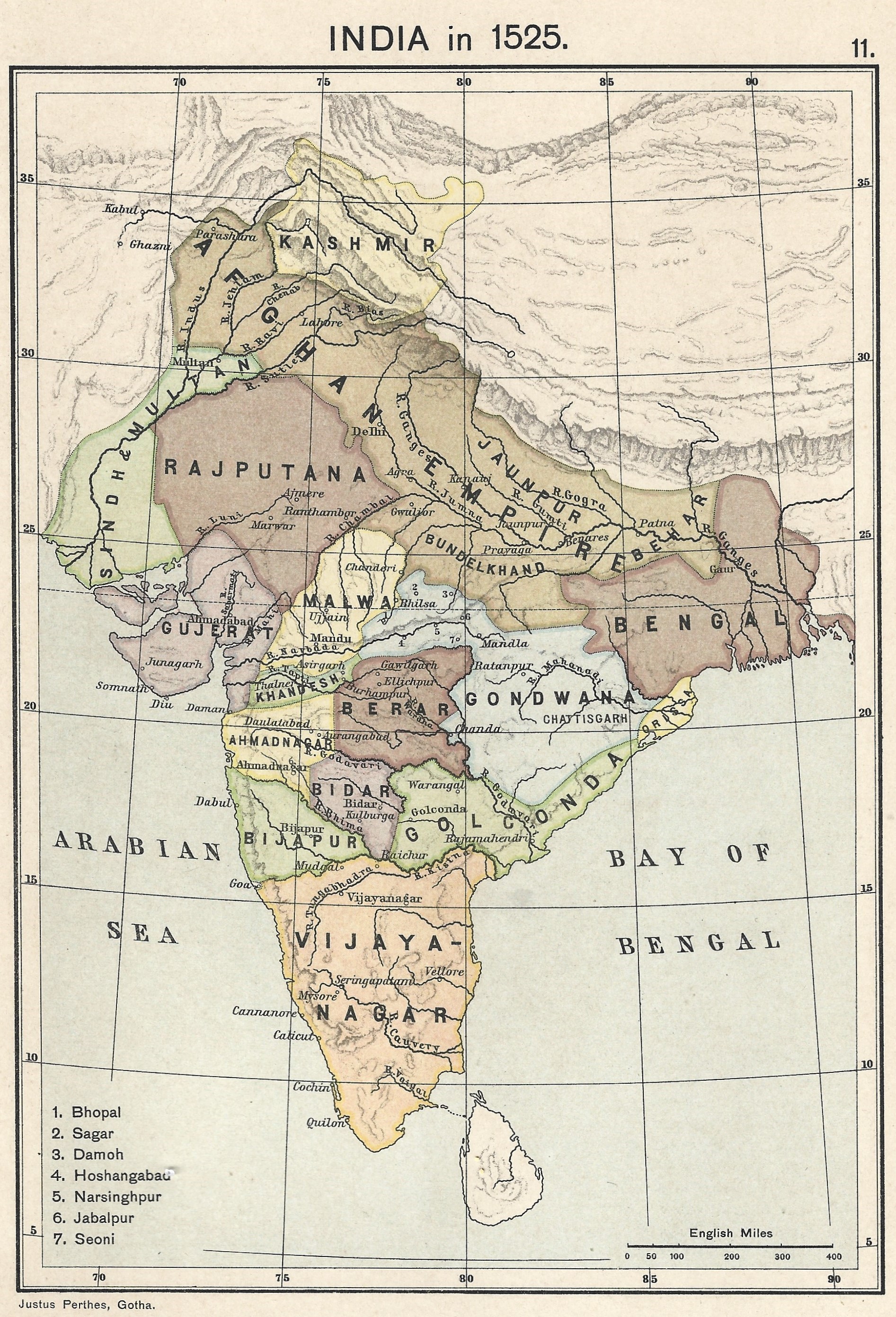
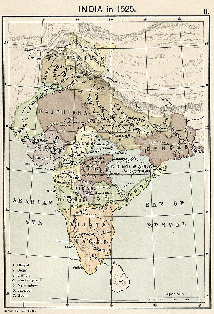
파일:Joppen map-India in 1525 published 1907 by Longmans.jpg
미리 보기 크기: 408 × 600 픽셀 다른 해상도: 163 × 240 픽셀 | 326 × 480 픽셀 | 522 × 768 픽셀 | 696 × 1,024 픽셀 | 1,893 × 2,783 픽셀
원본 파일 (1,893 × 2,783 픽셀, 파일 크기: 1.57 MB, MIME 종류: image/jpeg)
파일 설명
| 설명 |
English: A map of India in 1525 on the eve of the Mughal conquest of Upper India, scanned from the personal copy of Historical Atlas of India by Charles Joppen SJ, Longmans, Green and Co, 1907 by Fowler&fowler (토론) 13:52, 10 July 2023 (UTC) |
| 날짜 | |
| 출처 | Map of India 1525 showing India just before the Mughal conquest of Upper India from: Joppen, Charles [SJ.] (1907) A Historical Atlas of India for the use of High-Schools, Colleges, and Private Students, London, New York, Bombay, and Calcutta: Longman Green and Co. Pp. 16, 26 maps. |
| 저자 | Justus Perthes, Gotha./Charles Joppen Joppen, Charles [SJ.] (1907) A Historical Atlas of India for the use of High-Schools, Colleges, and Private Students, London, New York, Bombay, and Calcutta: Longman Green and Co. Pp. 16, 26 maps |
라이선스
이 작품은 1929년 1월 1일 이전에 출판하였으므로 미국에서 퍼블릭 도메인입니다.
퍼블릭 도메인 작품을 공용에 올리기 위해서는 미국과 작품의 제작 국가에서 저작권이 만료되어야 합니다. 미국에서 제작된 작품이 아닐 경우, 제작 국가에서의 저작권 상태를 나타내는 저작권 태그를 반드시 추가로 부착해야 합니다.
|
파일 역사
날짜/시간 링크를 클릭하면 해당 시간의 파일을 볼 수 있습니다.
| 날짜/시간 | 섬네일 | 크기 | 사용자 | 설명 | |
|---|---|---|---|---|---|
| 현재 | 2023년 7월 10일 (월) 22:52 | | 1,893 × 2,783 (1.57 MB) | Fowler&fowler | Uploaded a work by Justus Perthes, Gotha./Charles Joppen {{Citation|last=Joppen|first=Charles [SJ.]|year=1907|title=A Historical Atlas of India for the use of High-Schools, Colleges, and Private Students|publisher=London, New York, Bombay, and Calcutta: Longman Green and Co. Pp. 16, 26 maps}} from Map of India 1700 showing the Mughal Empire and European trading posts/factory towns from: {{Citation|last=Joppen|first=Charles [SJ.]|year=1907|title=A Historical Atlas of India for the use of High-... |
이 파일을 사용하는 문서
다음 문서 1개가 이 파일을 사용하고 있습니다:
이 파일을 사용하고 있는 모든 위키의 문서 목록
다음 위키에서 이 파일을 사용하고 있습니다:
- en.wikipedia.org에서 이 파일을 사용하고 있는 문서 목록