
파일:Leonhard Euler World Map AD1760.jpg

미리 보기 크기: 696 × 599 픽셀 다른 해상도: 279 × 240 픽셀 | 557 × 480 픽셀 | 892 × 768 픽셀 | 1,189 × 1,024 픽셀 | 2,378 × 2,048 픽셀 | 2,615 × 2,252 픽셀
원본 파일 (2,615 × 2,252 픽셀, 파일 크기: 2.79 MB, MIME 종류: image/jpeg)
파일 설명
| 설명 |
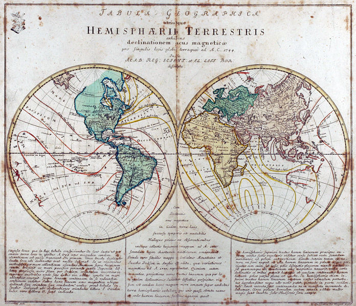
Tabula Geographica utriusque Hemisphaerii Terrestris exhibens declinationem acus magneticae pro singulis locis globi terraquei ad A. C. 1744. Iussu Acad: Reg: Scient: et El: Litt: Bor: descripta. Deutsch: Kupferstich-Weltkarte von Leonhard Euler aus seinem Schulatlas Geographischer Atlas bestehend in 44 Land-Charten erstmals 1753 in Berlin erschienen
English: Engraved world map (including magnetic declination lines) by Leonhard Euler from his school atlas “Geographischer Atlas bestehend in 44 Land-Charten” first published 1753 in Berlin |
||||||||||||||||||||||||||
| 날짜 | |||||||||||||||||||||||||||
| 출처 | Antique-World: Antique World Map by Leonhard Euler | ||||||||||||||||||||||||||
| 저자 |
|
||||||||||||||||||||||||||
| 저작권 (이 파일을 인용하기) |
Own work | ||||||||||||||||||||||||||

라이선스
|
이 작품은 미국, 그리고 저작권 보호 기간이 저작자 사후 100년, 또는 그 이하인 모든 국가에서 퍼블릭 도메인입니다. 이 작품은 1929년 1월 1일 이전에 출판하였으므로 미국에서 퍼블릭 도메인입니다. | |
| 이 저작물은 모든 저작인접권을 포함한 저작권법하의 규제로부터 자유로운 것으로 확인되었습니다. | |
파일 역사
날짜/시간 링크를 클릭하면 해당 시간의 파일을 볼 수 있습니다.
| 날짜/시간 | 섬네일 | 크기 | 사용자 | 설명 | |
|---|---|---|---|---|---|
| 현재 | 2008년 4월 26일 (토) 11:08 | | 2,615 × 2,252 (2.79 MB) | Ray007 | == Summary == {{Information |Description={{de|Kupferstich Weltkarte von Leonahrd Euler aus seinem Schulatlas "Geographischer Atlas bestehend in 44 Land-Charten" erstmals 1753 in Berlin erschienen}} {{en|Engraved world map by Leonahrd Euler from his school |
| 2008년 4월 26일 (토) 10:39 |  | 3,504 × 2,336 (4.88 MB) | Ray007 | {{Information |Description={{de|Kupferstich Weltkarte von Leonahrd Euler aus seinem Schulatlas "Geographischer Atlas bestehend in 44 Land-Charten" erstmals 1753 in Berlin erschienen}} {{en|Engraved world map by Leonahrd Euler from his school atlas "Geogra |
이 파일을 사용하는 문서
다음 문서 1개가 이 파일을 사용하고 있습니다:
이 파일을 사용하고 있는 모든 위키의 문서 목록
다음 위키에서 이 파일을 사용하고 있습니다:
- ar.wikipedia.org에서 이 파일을 사용하고 있는 문서 목록
- ast.wikipedia.org에서 이 파일을 사용하고 있는 문서 목록
- br.wikipedia.org에서 이 파일을 사용하고 있는 문서 목록
- de.wikipedia.org에서 이 파일을 사용하고 있는 문서 목록
- en.wikipedia.org에서 이 파일을 사용하고 있는 문서 목록
- eo.wikiquote.org에서 이 파일을 사용하고 있는 문서 목록
- eu.wikipedia.org에서 이 파일을 사용하고 있는 문서 목록
- fr.wikipedia.org에서 이 파일을 사용하고 있는 문서 목록
- ia.wikipedia.org에서 이 파일을 사용하고 있는 문서 목록
- pap.wikipedia.org에서 이 파일을 사용하고 있는 문서 목록
- ru.wikipedia.org에서 이 파일을 사용하고 있는 문서 목록
- sh.wikipedia.org에서 이 파일을 사용하고 있는 문서 목록
- sr.wikipedia.org에서 이 파일을 사용하고 있는 문서 목록
- tr.wikipedia.org에서 이 파일을 사용하고 있는 문서 목록
- www.wikidata.org에서 이 파일을 사용하고 있는 문서 목록