
파일:Luwian Language de.svg

SVG 파일의 PNG 형식의 미리보기 크기: 638 × 599 픽셀. 다른 해상도: 256 × 240 픽셀 | 511 × 480 픽셀 | 818 × 768 픽셀 | 1,090 × 1,024 픽셀 | 2,181 × 2,048 픽셀 | 790 × 742 픽셀
원본 파일 (SVG 파일, 실제 크기 790 × 742 픽셀, 파일 크기: 308 KB)
| 설명 |
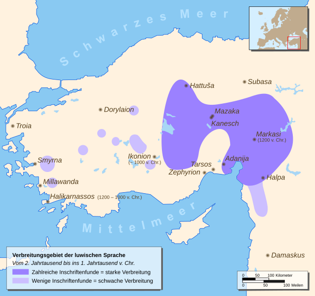
English: Map of a part of Eastern Europe/Asia with spreading of the Luwian Language
Deutsch: Karte mit Teilen Ost-Europas/Asiens mit dem Verbreitungsgebiet der luwischen Sprache |
| 날짜 | |
| 출처 |
Drawn by myself, based on different source maps: Continental outlines (by San Jose), Luwian Language spreading (by Enlil2), Cities, Locator map Enlil2 extracted the data from the book “The Luwians” (H. Craig Melchert, Brill 2003) |
| 저자 | Hendrik Tammen (Enricopedia ⇄) |
| 저작권 (이 파일을 인용하기) |
Author |
| 다른 버전 |
|


English: German translation of the city-names Deutsch: Übersetzung der Städtenamen
| ||
|---|---|---|
English: Ancient name Deutsch: Altertümlicher Name |
English: First settlements / City founded Deutsch: Erste Besiedlung / Stadtgründung |
English: Modern German name Deutsch: Heutiger Name
|
| Adanija | founded by Hittites | Adana |
| Damaskus | first settlements 5000 BC | Damaskus |
| Dorylaion (gr.) | founded by Hittites | Eskişehir |
| Halikarnassos (gr.) | founded 1200 – 1000 BC by Dorian Greeks | Bodrum |
| Halpa | first settlements 1900 BC | Aleppo |
| Hattuša | first settlements 6000 BC | Hattuša |
| Ikonion (gr.) | founded about 1000 BC | Konya |
| Kanesch | founded 1900 BC by Hittites | Kanesch |
| Markasi | founded 1200 BC | Kahramanmaras |
| Mazaka | founded by Hittites | Kayseri |
| Millawanda | founded about 3300 BC | Milet |
| Smyrna (gr.) | first settlements 10000 – 8000 BC | İzmir |
| Subasa | first settlements 7000 – 5000 BC | Sivas |
| Tarsos (gr.) | first settlements 4000 BC | Tarsus (lat.) |
| Troia / Τροία (gr.) | first settlements 3000 BC | Troja |
| Zephyrion (gr.) | founded 1500 – 1400 BC | Mersin |

|
이 SVG 파일은 편집 가능한 문자를 사용하므로 Inkscape나 Adobe Illustrator를 사용하여 쉽게 다른 언어로 번역할 수 있습니다. 여기를 참고하세요. 또한 텍스트 편집기를 이용하여 수동으로 파일을 번역할 수도 있습니다. |

|
This map has been made or improved in the German Kartenwerkstatt (Map Lab). You can propose maps to improve as well.
|
이 파일은 크리에이티브 커먼즈 저작자표시 2.5 일반 라이선스로 배포됩니다.
- 이용자는 다음의 권리를 갖습니다:
- 공유 및 이용 – 저작물의 복제, 배포, 전시, 공연 및 공중송신
- 재창작 – 저작물의 개작, 수정, 2차적저작물 창작
- 다음과 같은 조건을 따라야 합니다:
- 저작자표시 – 적절한 저작자 표시를 제공하고, 라이센스에 대한 링크를 제공하고, 변경사항이 있는지를 표시해야 합니다. 당신은 합리적인 방식으로 표시할 수 있지만, 어떤 방식으로든 사용권 허가자가 당신 또는 당신의 사용을 지지하는 방식으로 표시할 수 없습니다.
파일 역사
날짜/시간 링크를 클릭하면 해당 시간의 파일을 볼 수 있습니다.
| 날짜/시간 | 섬네일 | 크기 | 사용자 | 설명 | |
|---|---|---|---|---|---|
| 현재 | 2007년 1월 10일 (수) 07:22 | | 790 × 742 (308 KB) | Enricopedia | preview bugfix again |
| 2007년 1월 9일 (화) 00:39 |  | 790 × 742 (308 KB) | Enricopedia | Hattusa => Hattuša | |
| 2007년 1월 5일 (금) 07:49 |  | 790 × 742 (308 KB) | Enricopedia | changed some names | |
| 2007년 1월 4일 (목) 11:57 |  | 790 × 742 (310 KB) | Enricopedia | changed map design, using only ancient city names and showing only ancient cities | |
| 2007년 1월 3일 (수) 05:49 |  | 790 × 742 (300 KB) | Enricopedia | removed borders from the locator map | |
| 2007년 1월 2일 (화) 03:54 |  | 790 × 742 (433 KB) | Enricopedia | preview bugfix | |
| 2007년 1월 2일 (화) 02:38 |  | 790 × 742 (433 KB) | Enricopedia | added lakes, coast-lines and dates; code optimized | |
| 2006년 12월 27일 (수) 00:41 |  | 790 × 742 (428 KB) | Enricopedia | typo changes | |
| 2006년 12월 24일 (일) 01:57 |  | 790 × 742 (428 KB) | Enricopedia | added scale bar | |
| 2006년 12월 23일 (토) 23:22 |  | 790 × 742 (420 KB) | Enricopedia | typography changes |
이 파일을 사용하는 문서
다음 문서 1개가 이 파일을 사용하고 있습니다:
이 파일을 사용하고 있는 모든 위키의 문서 목록
다음 위키에서 이 파일을 사용하고 있습니다:
- ar.wikipedia.org에서 이 파일을 사용하고 있는 문서 목록
- ast.wikipedia.org에서 이 파일을 사용하고 있는 문서 목록
- azb.wikipedia.org에서 이 파일을 사용하고 있는 문서 목록
- az.wikipedia.org에서 이 파일을 사용하고 있는 문서 목록
- be-tarask.wikipedia.org에서 이 파일을 사용하고 있는 문서 목록
- be.wikipedia.org에서 이 파일을 사용하고 있는 문서 목록
- bg.wikipedia.org에서 이 파일을 사용하고 있는 문서 목록
- bn.wikipedia.org에서 이 파일을 사용하고 있는 문서 목록
- br.wikipedia.org에서 이 파일을 사용하고 있는 문서 목록
- ca.wikipedia.org에서 이 파일을 사용하고 있는 문서 목록
- de.wikipedia.org에서 이 파일을 사용하고 있는 문서 목록
- diq.wikipedia.org에서 이 파일을 사용하고 있는 문서 목록
- dsb.wikipedia.org에서 이 파일을 사용하고 있는 문서 목록
- el.wikipedia.org에서 이 파일을 사용하고 있는 문서 목록
- es.wikipedia.org에서 이 파일을 사용하고 있는 문서 목록
- et.wikipedia.org에서 이 파일을 사용하고 있는 문서 목록
- eu.wikipedia.org에서 이 파일을 사용하고 있는 문서 목록
- fa.wikipedia.org에서 이 파일을 사용하고 있는 문서 목록
- fi.wikipedia.org에서 이 파일을 사용하고 있는 문서 목록
- fr.wikipedia.org에서 이 파일을 사용하고 있는 문서 목록
- gl.wikipedia.org에서 이 파일을 사용하고 있는 문서 목록
- he.wikipedia.org에서 이 파일을 사용하고 있는 문서 목록
- hr.wikipedia.org에서 이 파일을 사용하고 있는 문서 목록
- hu.wikipedia.org에서 이 파일을 사용하고 있는 문서 목록
- id.wikipedia.org에서 이 파일을 사용하고 있는 문서 목록
- it.wikipedia.org에서 이 파일을 사용하고 있는 문서 목록
- lfn.wikipedia.org에서 이 파일을 사용하고 있는 문서 목록
- lt.wikipedia.org에서 이 파일을 사용하고 있는 문서 목록
- mk.wikipedia.org에서 이 파일을 사용하고 있는 문서 목록
- ml.wikipedia.org에서 이 파일을 사용하고 있는 문서 목록
- mzn.wikipedia.org에서 이 파일을 사용하고 있는 문서 목록
- nn.wikipedia.org에서 이 파일을 사용하고 있는 문서 목록
- no.wikipedia.org에서 이 파일을 사용하고 있는 문서 목록
- pl.wikipedia.org에서 이 파일을 사용하고 있는 문서 목록
- pt.wikipedia.org에서 이 파일을 사용하고 있는 문서 목록
- ru.wikipedia.org에서 이 파일을 사용하고 있는 문서 목록
- sl.wikipedia.org에서 이 파일을 사용하고 있는 문서 목록
이 파일의 더 많은 사용 내역을 봅니다.