
파일:Møns Klint 5.jpg

원본 파일 (2,387 × 1,690 픽셀, 파일 크기: 2.45 MB, MIME 종류: image/jpeg)
파일 설명
| 설명 |
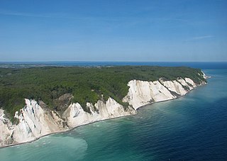
Deutsch: Ein Luftfoto von Møns Klint in Dänemark. In der Mitte sieht man Maglevands Fald mit Dronningestolen rechts. English: An aerial photo of Møns Klint (the Cliffs of Møn) in Denmark. Maglevands Fald is seen in the middle, with Dronningestolen on the right. |
||||
| 날짜 | |||||
| 출처 | 자작 | ||||
| 저자 | Bob Collowan | ||||
| 저작권 (이 파일을 인용하기) |
|
||||

| 대상 위치 | | 이 지역의 다른 사진을 보기: OpenStreetMap |
|---|
라이선스
- 이용자는 다음의 권리를 갖습니다:
- 공유 및 이용 – 저작물의 복제, 배포, 전시, 공연 및 공중송신
- 재창작 – 저작물의 개작, 수정, 2차적저작물 창작
- 다음과 같은 조건을 따라야 합니다:
- 저작자표시 – 적절한 저작자 표시를 제공하고, 라이센스에 대한 링크를 제공하고, 변경사항이 있는지를 표시해야 합니다. 당신은 합리적인 방식으로 표시할 수 있지만, 어떤 방식으로든 사용권 허가자가 당신 또는 당신의 사용을 지지하는 방식으로 표시할 수 없습니다.
- 동일조건변경허락 – 만약 당신이 이 저작물을 리믹스 또는 변형하거나 이 저작물을 기반으로 제작하는 경우, 당신은 당신의 기여물을 원저작물과 동일하거나 호환 가능한 라이선스에 따라 배포하여야 합니다.
| 주석 | 이 이미지에는 주석이 있습니다: 공용에서 주석을 보기 |

|
This is one of the images forming part of the Valued image set: Møns Klint (the Cliffs of Møn) on Wikimedia Commons. The image set has been assessed under the valued image set criteria and is considered the most valued set on Commons within the scope:
Møns Klint (the Cliffs of Møn)
You can see its nomination at Commons:Valued image candidates/Møns Klint. |
파일 역사
날짜/시간 링크를 클릭하면 해당 시간의 파일을 볼 수 있습니다.
| 날짜/시간 | 섬네일 | 크기 | 사용자 | 설명 | |
|---|---|---|---|---|---|
| 현재 | 2014년 6월 22일 (일) 01:10 | | 2,387 × 1,690 (2.45 MB) | Bob Collowân | Straightened horizon |
| 2013년 7월 4일 (목) 20:35 |  | 2,386 × 1,578 (2.5 MB) | Bob Collowân | User created page with UploadWizard |
이 파일을 사용하는 문서
다음 문서 1개가 이 파일을 사용하고 있습니다:
이 파일을 사용하고 있는 모든 위키의 문서 목록
다음 위키에서 이 파일을 사용하고 있습니다:
- cs.wikipedia.org에서 이 파일을 사용하고 있는 문서 목록
- da.wikipedia.org에서 이 파일을 사용하고 있는 문서 목록
- de.wikivoyage.org에서 이 파일을 사용하고 있는 문서 목록
- en.wikipedia.org에서 이 파일을 사용하고 있는 문서 목록
- is.wikipedia.org에서 이 파일을 사용하고 있는 문서 목록
- lv.wikipedia.org에서 이 파일을 사용하고 있는 문서 목록
- pl.wikivoyage.org에서 이 파일을 사용하고 있는 문서 목록
- pt.wikipedia.org에서 이 파일을 사용하고 있는 문서 목록
- th.wikipedia.org에서 이 파일을 사용하고 있는 문서 목록