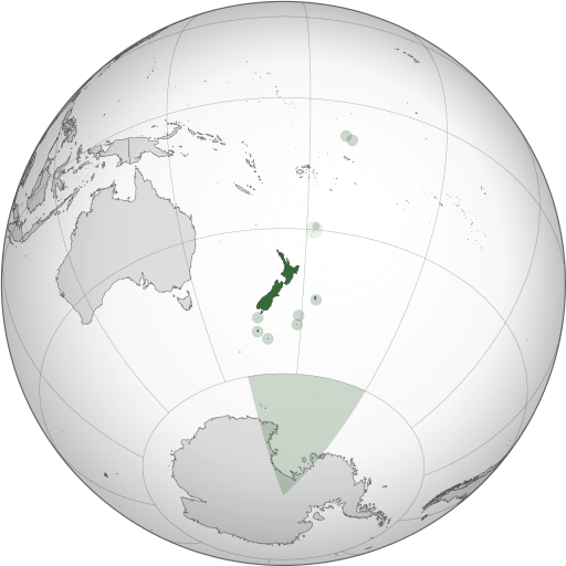
파일:NZL orthographic NaturalEarth.svg

SVG 파일의 PNG 형식의 미리보기 크기: 512 × 512 픽셀. 다른 해상도: 240 × 240 픽셀 | 480 × 480 픽셀 | 768 × 768 픽셀 | 1,024 × 1,024 픽셀 | 2,048 × 2,048 픽셀
원본 파일 (SVG 파일, 실제 크기 512 × 512 픽셀, 파일 크기: 574 KB)
파일 역사
날짜/시간 링크를 클릭하면 해당 시간의 파일을 볼 수 있습니다.
| 날짜/시간 | 섬네일 | 크기 | 사용자 | 설명 | |
|---|---|---|---|---|---|
| 현재 | 2013년 11월 1일 (금) 07:06 |  | 512 × 512 (574 KB) | TooncesB | == Summary == {{Information |Description={{en|1=A map of the hemisphere centred on Wellington, New Zealand, using an orthographic projection, created using gringer's Perl script with [http://www.naturalear... |
| 2013년 10월 6일 (일) 08:52 |  | 553 × 553 (505 KB) | TooncesB | {{Information |Description={{en|1=A map of the hemisphere centred on Wellington, New Zealand, using an orthographic projection, created using gringer's Perl script with [http://www.naturalearthdata.com/ Na... | |
| 2013년 10월 2일 (수) 22:22 |  | 553 × 553 (504 KB) | TooncesB | {{Information |Description={{en|1=A map of the hemisphere centred on Wellington, New Zealand, using an orthographic projection, created using gringer's Perl script with [http://www.naturalearthdata.com/ Na... | |
| 2013년 10월 2일 (수) 05:07 |  | 553 × 553 (556 KB) | TooncesB | {{Information |Description={{en|1=A map of the hemisphere centred on Wellington, New Zealand, using an orthographic projection, created using gringer's Perl script with [http://www.naturalearthdata.com/ Na... | |
| 2013년 5월 1일 (수) 23:41 |  | 553 × 553 (558 KB) | Gringer | Updated generation script (still needs some Inkscape hand-holding). Slightly larger image. Used high-resolution (10m) shapes for all countries, added highlight circles and Antarctica claim. | |
| 2010년 9월 1일 (수) 13:35 |  | 550 × 550 (398 KB) | Gringer | Using high resolution (10m) shapes for New Zealand, removed odd Antarctica spike. | |
| 2010년 8월 31일 (화) 08:13 |  | 550 × 550 (250 KB) | Gringer | changed size to fit with recommendations, white sea | |
| 2010년 8월 31일 (화) 07:54 |  | 1,050 × 1,050 (249 KB) | Gringer | {{Information |Description={{en|1=A map of the hemisphere centred on Wellington, New Zealand, using an orthographic projection, created using gringer's [[[w:User:Gringer/perlshaper|Perl script] with [http://www.naturalearthdata.com/ Natur |
이 파일을 사용하는 문서
이 파일을 사용하고 있는 모든 위키의 문서 목록
다음 위키에서 이 파일을 사용하고 있습니다:
- ace.wikipedia.org에서 이 파일을 사용하고 있는 문서 목록
- ami.wikipedia.org에서 이 파일을 사용하고 있는 문서 목록
- ar.wikipedia.org에서 이 파일을 사용하고 있는 문서 목록
- as.wikipedia.org에서 이 파일을 사용하고 있는 문서 목록
- azb.wikipedia.org에서 이 파일을 사용하고 있는 문서 목록
- bg.wikipedia.org에서 이 파일을 사용하고 있는 문서 목록
- bh.wikipedia.org에서 이 파일을 사용하고 있는 문서 목록
- bn.wikipedia.org에서 이 파일을 사용하고 있는 문서 목록
- bs.wikipedia.org에서 이 파일을 사용하고 있는 문서 목록
- cdo.wikipedia.org에서 이 파일을 사용하고 있는 문서 목록
- ceb.wikipedia.org에서 이 파일을 사용하고 있는 문서 목록
- ckb.wikipedia.org에서 이 파일을 사용하고 있는 문서 목록
- cs.wikipedia.org에서 이 파일을 사용하고 있는 문서 목록
- da.wikipedia.org에서 이 파일을 사용하고 있는 문서 목록
- diq.wikipedia.org에서 이 파일을 사용하고 있는 문서 목록
- ee.wikipedia.org에서 이 파일을 사용하고 있는 문서 목록
- el.wikipedia.org에서 이 파일을 사용하고 있는 문서 목록
- en.wikipedia.org에서 이 파일을 사용하고 있는 문서 목록
- Portal:New Zealand
- User talk:Gringer
- New Zealand
- User:LJ Holden/dreams
- The Amazing Race 22
- User:J4kob123/sandbox
- User:Lbothwe/New Zealand
- User:Artemis Andromeda/sandbox/WikiBelta/Zealand Nuva
- Talk:List of guests at the state funeral of Elizabeth II
- Installations of the United States Navy in New Zealand
- en.wikibooks.org에서 이 파일을 사용하고 있는 문서 목록
- en.wiktionary.org에서 이 파일을 사용하고 있는 문서 목록
- es.wikipedia.org에서 이 파일을 사용하고 있는 문서 목록
- eu.wikipedia.org에서 이 파일을 사용하고 있는 문서 목록
- fa.wikipedia.org에서 이 파일을 사용하고 있는 문서 목록
- fi.wikipedia.org에서 이 파일을 사용하고 있는 문서 목록
- fj.wikipedia.org에서 이 파일을 사용하고 있는 문서 목록
- fr.wikipedia.org에서 이 파일을 사용하고 있는 문서 목록
- gl.wikipedia.org에서 이 파일을 사용하고 있는 문서 목록
- gn.wikipedia.org에서 이 파일을 사용하고 있는 문서 목록
- gu.wikipedia.org에서 이 파일을 사용하고 있는 문서 목록
- hak.wikipedia.org에서 이 파일을 사용하고 있는 문서 목록
- hif.wikipedia.org에서 이 파일을 사용하고 있는 문서 목록
- hi.wikipedia.org에서 이 파일을 사용하고 있는 문서 목록
- hr.wikipedia.org에서 이 파일을 사용하고 있는 문서 목록
- id.wikipedia.org에서 이 파일을 사용하고 있는 문서 목록
이 파일의 더 많은 사용 내역을 봅니다.


