
파일:Nepkoztarsasag.png
최대 해상도입니다.
Nepkoztarsasag.png (660 × 428 픽셀, 파일 크기: 55 KB, MIME 종류: image/png)
Accuracy
파일 설명
| 설명 |
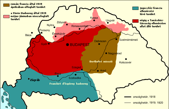
English: Military success of the Hungarian Soviet Republic Territory under Romanian and French control in April, 1919 Territory under the control of the Hungarian Soviet Republic Territory recovered by the Hungarian Soviet Republic Territory under French and Yugoslav control
Italiano: Situazione territoriale della Repubblica sovietica ungherese Territori sotto il controllo rumeno e francese nell'aprile 1919 Territori sotto il controllo della Repubblica sovietica ungherese Territori riconquistati dalla Repubblica sovietica ungherese Territori sotto il controllo francese e jugoslavo
Español: Situación territorial durante el periodo de la República Soviética Húngara Territorio bajo control rumano-francés en abril de 1919. Territorio originalmente bajo control de la República Soviética Húngara Territorio recuperado por la República a Checoslovaquia Territorio bajo control franco-yugoslavo |
| 날짜 | |
| 출처 |
hu.wikipedia에서 공용으로 옮겨왔습니다. The original description page was here. All following user names refer to hu.wikipedia. |
| 저자 | Kovács Ádám |
| 다른 버전 | 이 파일은 다음으로 파생됨: RepúblicaSoviéticaHúngara1919.svg; Georgian Version SVG |
라이선스
이 파일은 크리에이티브 커먼즈 저작자표시-동일조건변경허락 2.5 일반 라이선스로 배포됩니다.
- 이용자는 다음의 권리를 갖습니다:
- 공유 및 이용 – 저작물의 복제, 배포, 전시, 공연 및 공중송신
- 재창작 – 저작물의 개작, 수정, 2차적저작물 창작
- 다음과 같은 조건을 따라야 합니다:
- 저작자표시 – 적절한 저작자 표시를 제공하고, 라이센스에 대한 링크를 제공하고, 변경사항이 있는지를 표시해야 합니다. 당신은 합리적인 방식으로 표시할 수 있지만, 어떤 방식으로든 사용권 허가자가 당신 또는 당신의 사용을 지지하는 방식으로 표시할 수 없습니다.
- 동일조건변경허락 – 만약 당신이 이 저작물을 리믹스 또는 변형하거나 이 저작물을 기반으로 제작하는 경우, 당신은 당신의 기여물을 원저작물과 동일하거나 호환 가능한 라이선스에 따라 배포하여야 합니다.
파일 역사
날짜/시간 링크를 클릭하면 해당 시간의 파일을 볼 수 있습니다.
| 날짜/시간 | 섬네일 | 크기 | 사용자 | 설명 | |
|---|---|---|---|---|---|
| 현재 | 2017년 11월 22일 (수) 22:15 | | 660 × 428 (55 KB) | Julieta39 | Diacritic corrected |
| 2017년 11월 22일 (수) 21:04 |  | 660 × 428 (55 KB) | Julieta39 | According with "Történelmi atlasz", Kartográfiai Vállalat, Budapest 1989, ISBN 9633514223 CM | |
| 2011년 2월 9일 (수) 20:08 |  | 660 × 428 (47 KB) | Hobartimus~commonswiki | Reverted to version as of 18:15, 6 February 2011 | |
| 2011년 2월 9일 (수) 09:20 |  | 660 × 428 (23 KB) | Lovech~commonswiki | returning to the superior original version | |
| 2011년 2월 7일 (월) 03:15 |  | 660 × 428 (47 KB) | 123iti | reverted unexplained edit | |
| 2011년 2월 6일 (일) 01:40 |  | 660 × 428 (23 KB) | Lovech~commonswiki | Reverted to version as of 22:33, 28 December 2010 | |
| 2010년 12월 29일 (수) 09:17 |  | 660 × 428 (47 KB) | 123iti | ok, then I am proposing this compromise version due to my discussion page explanation | |
| 2010년 12월 29일 (수) 07:33 |  | 660 × 428 (23 KB) | VT | Reverted to version as of 13:20, 20 May 2009 -> this version is right, then those territories were under occupation | |
| 2010년 12월 6일 (월) 20:53 |  | 660 × 428 (35 KB) | 123iti | There is no reason that vojvodina is colored here because it had no any relation with Hungarian Soviet Republic. See source: http://libcom.org/files/images/library/hungarianmap%5B1%5D.jpg (Transylvania, Slovakia and Transcarpathia are not colored too, so | |
| 2009년 5월 20일 (수) 22:20 |  | 660 × 428 (23 KB) | Baxter9~commonswiki | {{Information |Description={{en|1=Military succes of the Hungarian Soviet Republic}} |Source=http://hu.wikipedia.org/wiki/F%C3%A1jl:Nepkoztarsasag.png |Author=Kovács Ádám |Date=2006 |Permission= |other_versions= }} <!--{{ImageUpload|full}}--> [[Catego |
이 파일을 사용하는 문서
다음 문서 2개가 이 파일을 사용하고 있습니다:
이 파일을 사용하고 있는 모든 위키의 문서 목록
다음 위키에서 이 파일을 사용하고 있습니다:
- ar.wikipedia.org에서 이 파일을 사용하고 있는 문서 목록
- ast.wikipedia.org에서 이 파일을 사용하고 있는 문서 목록
- azb.wikipedia.org에서 이 파일을 사용하고 있는 문서 목록
- az.wikipedia.org에서 이 파일을 사용하고 있는 문서 목록
- be.wikipedia.org에서 이 파일을 사용하고 있는 문서 목록
- bg.wikipedia.org에서 이 파일을 사용하고 있는 문서 목록
- cbk-zam.wikipedia.org에서 이 파일을 사용하고 있는 문서 목록
- cs.wikipedia.org에서 이 파일을 사용하고 있는 문서 목록
- da.wikipedia.org에서 이 파일을 사용하고 있는 문서 목록
- el.wikipedia.org에서 이 파일을 사용하고 있는 문서 목록
- en.wikipedia.org에서 이 파일을 사용하고 있는 문서 목록
- eo.wikipedia.org에서 이 파일을 사용하고 있는 문서 목록
- et.wikipedia.org에서 이 파일을 사용하고 있는 문서 목록
- eu.wikipedia.org에서 이 파일을 사용하고 있는 문서 목록
- fa.wikipedia.org에서 이 파일을 사용하고 있는 문서 목록
- fr.wikipedia.org에서 이 파일을 사용하고 있는 문서 목록
- gl.wikipedia.org에서 이 파일을 사용하고 있는 문서 목록
- hr.wikipedia.org에서 이 파일을 사용하고 있는 문서 목록
- hu.wikipedia.org에서 이 파일을 사용하고 있는 문서 목록
- hy.wikipedia.org에서 이 파일을 사용하고 있는 문서 목록
- id.wikipedia.org에서 이 파일을 사용하고 있는 문서 목록
- it.wikipedia.org에서 이 파일을 사용하고 있는 문서 목록
- ja.wikipedia.org에서 이 파일을 사용하고 있는 문서 목록
- ka.wikipedia.org에서 이 파일을 사용하고 있는 문서 목록
- kk.wikipedia.org에서 이 파일을 사용하고 있는 문서 목록
- la.wikipedia.org에서 이 파일을 사용하고 있는 문서 목록
- lv.wikipedia.org에서 이 파일을 사용하고 있는 문서 목록
이 파일의 더 많은 사용 내역을 봅니다.