
파일:PIA20133-Ceres-DwarfPlanet-Dawn-3rdMapOrbit-HAMO-image70-20151006.jpg

원본 파일 (1,024 × 1,024 픽셀, 파일 크기: 204 KB, MIME 종류: image/jpeg)
파일 설명
| 설명 |
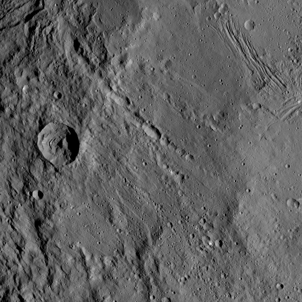
English: PIA20133: Dawn HAMO Image 70
http://photojournal.jpl.nasa.gov/catalog/PIA20133 This view from NASA's Dawn spacecraft shows different types of terrain located side by side on Ceres: a smooth terrain at right with numerous small impact craters, and a less-cratered, hummocky terrain at left. A huge crater chain crosses the scene diagonally from upper left to lower right. The smooth terrain, which is in the western part of Yalode impact basin, is interrupted by a set of roughly parallel furrows and ridges at upper right. These linear features are perpendicular to another set of smaller, fainter linear markings, which appear just below them. An impact into the hummocky terrain formed a crater, seen at left, 14 miles (22 kilometers) in diameter with a central peak. A great deal of material has slumped down the walls of the crater -- a phenomenon called mass wasting. The crater's impact ejecta forms a smooth blanket around its rim, which takes on a streaky texture leading away from the crater toward lower right. The image was taken during in Dawn's High Altitude Mapping Orbit (HAMO) phase from an altitude of 911 miles (1,466 kilometers) on Oct. 6, 2015. Image resolution is 394 feet (120 meters) per pixel. The image is centered at 37 degrees south latitude, 279 degrees east longitude. Dawn's mission is managed by JPL for NASA's Science Mission Directorate in Washington. Dawn is a project of the directorate's Discovery Program, managed by NASA's Marshall Space Flight Center in Huntsville, Alabama. UCLA is responsible for overall Dawn mission science. Orbital ATK, Inc., in Dulles, Virginia, designed and built the spacecraft. The German Aerospace Center, the Max Planck Institute for Solar System Research, the Italian Space Agency and the Italian National Astrophysical Institute are international partners on the mission team. For a complete list of acknowledgments, see http://dawn.jpl.nasa.gov/mission. For more information about the Dawn mission, visit http://dawn.jpl.nasa.gov. |
| 날짜 | |
| 출처 | http://photojournal.jpl.nasa.gov/jpeg/PIA20133.jpg |
| 저자 | NASA/JPL-Caltech/UCLA/MPS/DLR/IDA |
라이선스
| 이 파일은 NASA에서 제작하였으므로 퍼블릭 도메인입니다. NASA의 저작권 정책에 따르면 NASA의 자료는 명시하지 않는 이상 저작권의 보호를 받지 않습니다. (Template:PD-USGov, 또는 NASA 저작권 정책 문서, JPL 그림 사용 정책을 참고하세요.) | ||
 |
주의사항:
|
파일 역사
날짜/시간 링크를 클릭하면 해당 시간의 파일을 볼 수 있습니다.
| 날짜/시간 | 섬네일 | 크기 | 사용자 | 설명 | |
|---|---|---|---|---|---|
| 현재 | 2015년 12월 5일 (토) 03:52 | | 1,024 × 1,024 (204 KB) | Drbogdan | User created page with UploadWizard |
이 파일을 사용하는 문서
이 파일을 사용하는 문서가 없습니다.