
파일:Peloponnesian war alliances 431 BC.png
미리 보기 크기: 387 × 600 픽셀 다른 해상도: 155 × 240 픽셀 | 482 × 747 픽셀
원본 파일 (482 × 747 픽셀, 파일 크기: 37 KB, MIME 종류: image/png)
파일 설명

|
이 그림은 벡터 그래픽 버전(SVG)이 있습니다. 래스터(비트맵) 그림 대신 벡터 그래픽 그림을 사용하는 것이 좋습니다.
File:Peloponnesian war alliances 431 BC.png → File:Guerre del Peloponneso 431aC mappa.svg
|
 |
| 설명 |
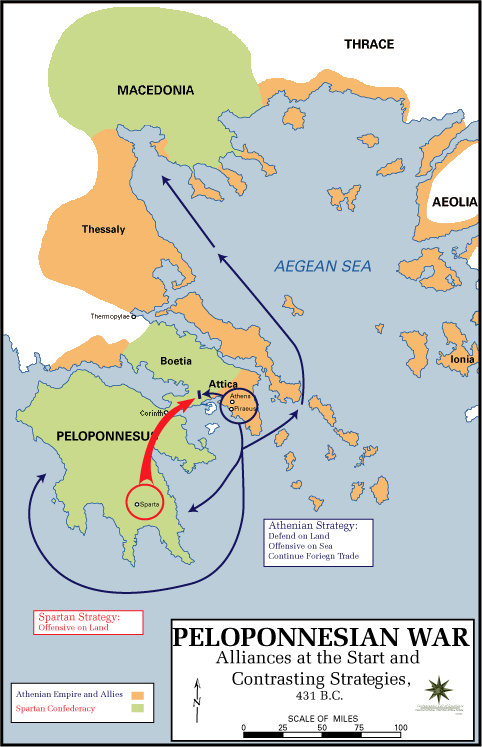
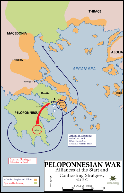
English: The Alliances of the Peloponnesian War |
| 날짜 | 2009년 5월 5일 (원본 올리기 일시) |
| 출처 |
|
| 저자 | U.S. Army Cartographer, as amended by uploader to correct spelling mistake |
| 저작권 (이 파일을 인용하기) |
Public domain as a work of the U.S. military.; amendments also released into the public domain |
| 다른 버전 |
|
라이선스
이 파일은 미국 법전 제17편 제1장 제105조에 따른 미국 연방정부의 공무원 또는 피고용인이 공무상 작성한 저작물로, 미국에서 퍼블릭 도메인입니다.
주의: 본 라이선스는 미국 연방정부의 저작물에 관해서만 효력이 있습니다. 미국의 주, 군, 기타 지방자치단체가 만든 저작물에 대해서는 적용되지 않습니다. 또한 미국 우정청이 1978년부터 발행한 우표 디자인에도 적용되지 않습니다.
|
 | |
| 이 저작물은 모든 저작인접권을 포함한 저작권법하의 규제로부터 자유로운 것으로 확인되었습니다. | ||
기존 올리기 기록
The original description page was here. All following user names refer to en.wikipedia.
- 2009-05-05 11:43 The Anome 482×747× (34269 bytes) Fixed second spelling mistake, which had been accidentally reinstated by reverting to original source.
- 2009-05-05 11:28 The Anome 482×747× (34263 bytes) {{Information |Description = The Alliances of the Peloponnesian War |Source = http://www.faculty.umb.edu/gary_zabel/Courses/Phil%20281b/Maps/peloponnesian_war_alliances.gif |Date = |Author = U.S. Army Cartographer, as ame
파일 역사
날짜/시간 링크를 클릭하면 해당 시간의 파일을 볼 수 있습니다.
| 날짜/시간 | 섬네일 | 크기 | 사용자 | 설명 | |
|---|---|---|---|---|---|
| 현재 | 2018년 3월 31일 (토) 04:35 | | 482 × 747 (37 KB) | Trecătorul răcit | Gulf of Pella in the time, position of names |
| 2009년 5월 5일 (화) 21:03 |  | 482 × 747 (33 KB) | File Upload Bot (Magnus Manske) | {{BotMoveToCommons|en.wikipedia|year={{subst:CURRENTYEAR}}|month={{subst:CURRENTMONTHNAME}}|day={{subst:CURRENTDAY}}}} {{Information |Description={{en|The Alliances of the Peloponnesian War}} |Source=Transferred from [http://en.wikipedia.org en.wikipedia |
이 파일을 사용하는 문서
다음 문서 1개가 이 파일을 사용하고 있습니다:
이 파일을 사용하고 있는 모든 위키의 문서 목록
다음 위키에서 이 파일을 사용하고 있습니다:
- ar.wikipedia.org에서 이 파일을 사용하고 있는 문서 목록
- br.wikipedia.org에서 이 파일을 사용하고 있는 문서 목록
- ca.wikipedia.org에서 이 파일을 사용하고 있는 문서 목록
- da.wikipedia.org에서 이 파일을 사용하고 있는 문서 목록
- el.wikipedia.org에서 이 파일을 사용하고 있는 문서 목록
- en.wikipedia.org에서 이 파일을 사용하고 있는 문서 목록
- et.wikipedia.org에서 이 파일을 사용하고 있는 문서 목록
- eu.wikipedia.org에서 이 파일을 사용하고 있는 문서 목록
- fa.wikipedia.org에서 이 파일을 사용하고 있는 문서 목록
- fi.wikipedia.org에서 이 파일을 사용하고 있는 문서 목록
- fr.wikipedia.org에서 이 파일을 사용하고 있는 문서 목록
- hyw.wikipedia.org에서 이 파일을 사용하고 있는 문서 목록
- id.wikibooks.org에서 이 파일을 사용하고 있는 문서 목록
- it.wikipedia.org에서 이 파일을 사용하고 있는 문서 목록
- ka.wikipedia.org에서 이 파일을 사용하고 있는 문서 목록
- lv.wikipedia.org에서 이 파일을 사용하고 있는 문서 목록
- ml.wikipedia.org에서 이 파일을 사용하고 있는 문서 목록
- ro.wikipedia.org에서 이 파일을 사용하고 있는 문서 목록
- ru.wikipedia.org에서 이 파일을 사용하고 있는 문서 목록
- sh.wikipedia.org에서 이 파일을 사용하고 있는 문서 목록
- sk.wikipedia.org에서 이 파일을 사용하고 있는 문서 목록
- sq.wikipedia.org에서 이 파일을 사용하고 있는 문서 목록
- sr.wikipedia.org에서 이 파일을 사용하고 있는 문서 목록
- ta.wikipedia.org에서 이 파일을 사용하고 있는 문서 목록
- th.wikipedia.org에서 이 파일을 사용하고 있는 문서 목록
- tr.wikipedia.org에서 이 파일을 사용하고 있는 문서 목록
- vi.wikipedia.org에서 이 파일을 사용하고 있는 문서 목록
- xmf.wikipedia.org에서 이 파일을 사용하고 있는 문서 목록
- yo.wikipedia.org에서 이 파일을 사용하고 있는 문서 목록
- zh-yue.wikipedia.org에서 이 파일을 사용하고 있는 문서 목록
- zh.wikipedia.org에서 이 파일을 사용하고 있는 문서 목록
- zh.wikibooks.org에서 이 파일을 사용하고 있는 문서 목록