
파일:Pusan Perimeter (ko).jpg
최대 해상도입니다.
Pusan_Perimeter_(ko).jpg (350 × 572 픽셀, 파일 크기: 118 KB, MIME 종류: image/jpeg)
파일 설명
| 설명 |
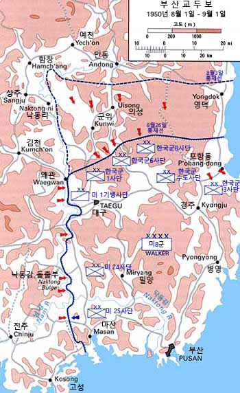
English: Map of the Pusan Perimeter, August 1950. |
| 날짜 | |
| 출처 |
English: This map was created by the Center for Military History and used in the brochure "The Korean War: The Outbreak" located at [1].
Localization work of:
|
| 저자 |

.jpg?uselang=ko)
라이선스
| This image is in the public domain because it contains materials that originally came from the United States Army Center of Military History, subject to the following qualification.
Note: The images of all badges, insignia, decorations and medals on the "CMH Online" web site are produced by the United States Army Institute of Heraldry and protected by Title 18, United States Code, Section 704 and the Code of Federal Regulations (32 CFR, Part 507). Permission to use these images for commercial purposes must be obtained from The Institute of Heraldry prior to their use. |

|
파일 역사
날짜/시간 링크를 클릭하면 해당 시간의 파일을 볼 수 있습니다.
| 날짜/시간 | 섬네일 | 크기 | 사용자 | 설명 | |
|---|---|---|---|---|---|
| 현재 | 2017년 4월 9일 (일) 00:44 | | 350 × 572 (118 KB) | Howard61313 | User created page with UploadWizard |
이 파일을 사용하는 문서
다음 문서 3개가 이 파일을 사용하고 있습니다:
.jpg)