
파일:RedSea.A2004273.1050.250m.jpg

미리 보기 크기: 457 × 600 픽셀 다른 해상도: 183 × 240 픽셀 | 366 × 480 픽셀 | 585 × 768 픽셀 | 780 × 1,024 픽셀 | 1,560 × 2,048 픽셀 | 6,400 × 8,400 픽셀
원본 파일 (6,400 × 8,400 픽셀, 파일 크기: 6.69 MB, MIME 종류: image/jpeg)
| 주의 | 이 그림은 크기가 상당히 크며, 일부 브라우저의 경우 그림을 실제 크기로 표시할 때 프로그램이 멈출 수 있습니다. 이 경우, '최대 해상도' 링크 위에서 마우스 오른쪽 버튼을 눌러서 컴퓨터 파일로 저장한 다음, 포토샵이나 GIMP 같은 편집기를 이용해서 파일을 열어 주세요. |
|---|
파일 설명
| 설명 |
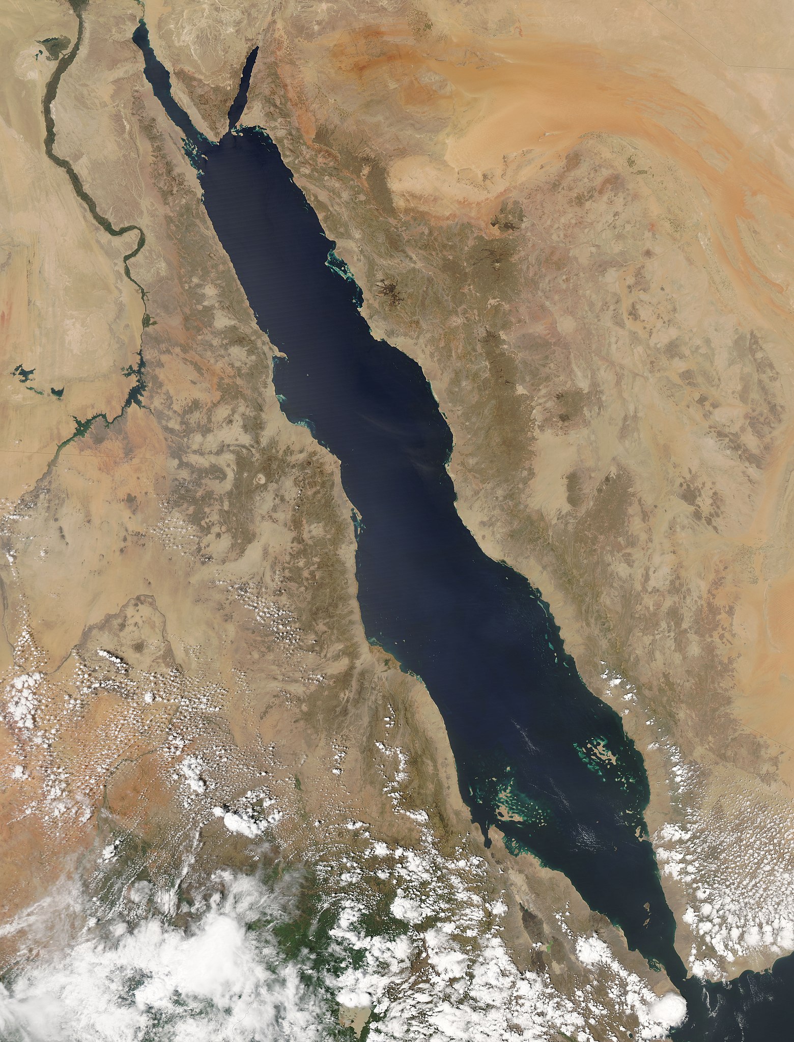
English: "The oblong shape of the Red Sea cuts diagonally through this true-color Aqua MODIS image from September 29, 2004. The sea's deep, clear blue waters stand out in stark contrast to the pale tan and orange sands of the surrounding deserts in northeastern Africa, the Sinai Peninsula, and the western Arabian Peninsula. Clockwise from upper left, the nations are Egypt, Israel, Jordan, Saudi Arabia, Yemen, Eritrea (on the coast of the Red Sea), Ethiopia (bottom image edge), and Sudan. At the southern end of the Red Sea, the Dahlak Archipelago is marked by tiny tan islands and green shallow waters. The dark green ribbon of the Nile River flows northwards through Egypt and Sudan in the upper left portion of the image." (from NASA's Visible Earth) |
| 날짜 | |
| 출처 | NASA Visible Earth (Direct link: RedSea.A2004273.1050.250m.jpg |
| 저자 | Jeff Schmaltz, MODIS Rapid Response Team, NASA/GSFC |
| 저작권 (이 파일을 인용하기) |
PD |
라이선스
| 이 파일은 NASA에서 제작하였으므로 퍼블릭 도메인입니다. NASA의 저작권 정책에 따르면 NASA의 자료는 명시하지 않는 이상 저작권의 보호를 받지 않습니다. (Template:PD-USGov, 또는 NASA 저작권 정책 문서, JPL 그림 사용 정책을 참고하세요.) | ||
 |
주의사항:
|
파일 역사
날짜/시간 링크를 클릭하면 해당 시간의 파일을 볼 수 있습니다.
| 날짜/시간 | 섬네일 | 크기 | 사용자 | 설명 | |
|---|---|---|---|---|---|
| 현재 | 2008년 2월 4일 (월) 09:44 | | 6,400 × 8,400 (6.69 MB) | Iamunknown | {{Information |Description={{en|"The oblong shape of the Red Sea cuts diagonally through this true-color Aqua MODIS image from September 29, 2004. The sea's deep, clear blue waters stand out in stark contrast to the pale tan and orange sands of the surrou |
이 파일을 사용하는 문서
다음 문서 1개가 이 파일을 사용하고 있습니다:
이 파일을 사용하고 있는 모든 위키의 문서 목록
다음 위키에서 이 파일을 사용하고 있습니다:
- af.wikipedia.org에서 이 파일을 사용하고 있는 문서 목록
- kv.wikipedia.org에서 이 파일을 사용하고 있는 문서 목록
- pt.wikipedia.org에서 이 파일을 사용하고 있는 문서 목록
- rm.wikipedia.org에서 이 파일을 사용하고 있는 문서 목록
- su.wikipedia.org에서 이 파일을 사용하고 있는 문서 목록