
파일:Stielers Handatlas 1891 62 NE.jpg
미리 보기 크기: 600 × 600 픽셀 다른 해상도: 240 × 240 픽셀 | 480 × 480 픽셀 | 768 × 768 픽셀 | 1,250 × 1,250 픽셀
원본 파일 (1,250 × 1,250 픽셀, 파일 크기: 687 KB, MIME 종류: image/jpeg)
| 설명 |
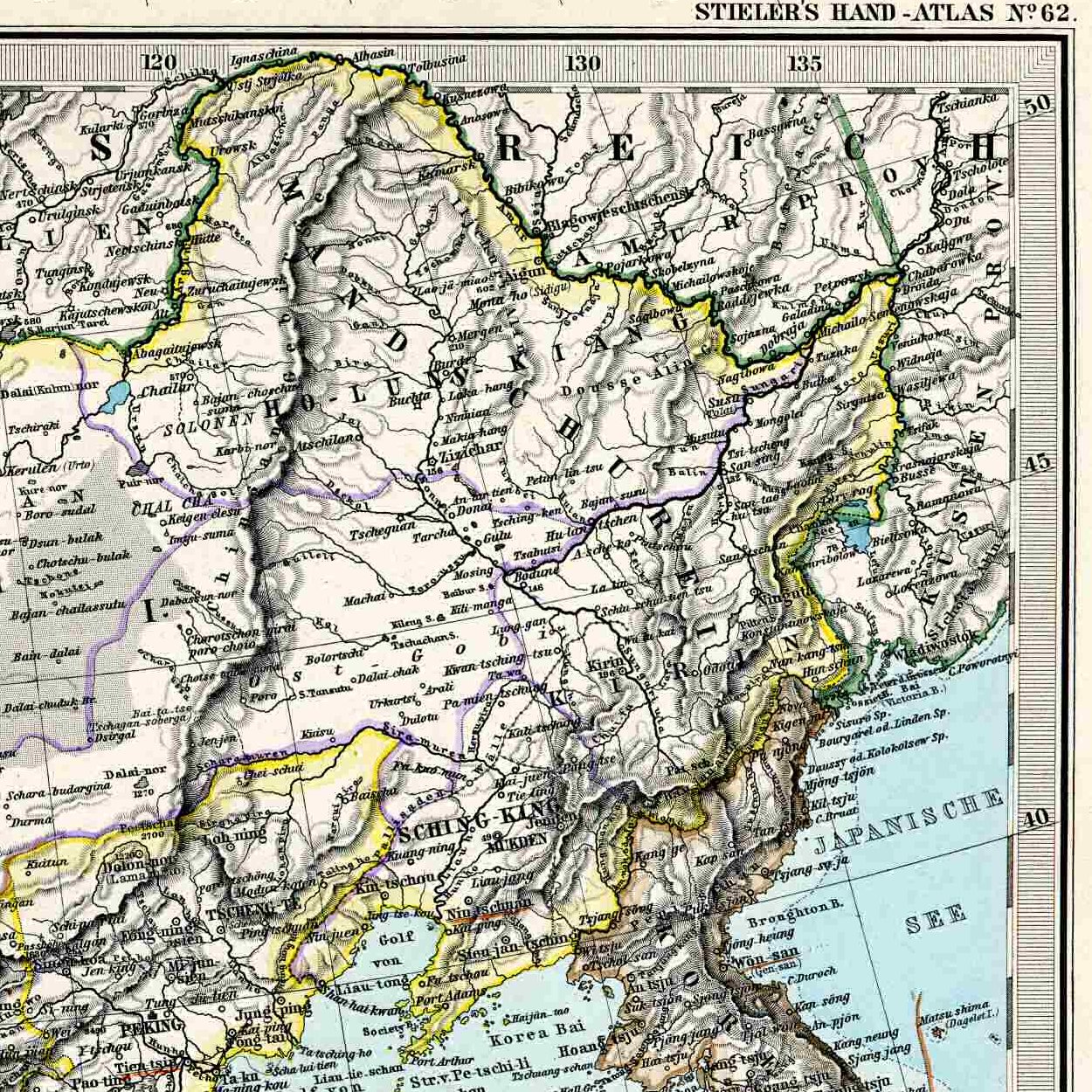
English: Northeastern corner of the 1892 map of China, for inclusion into articles about Manchuria. |
| 날짜 | (UTC) |
| 출처 | |
| 저자 |
|
| 다른 버전 |
Entire map:  |
| 이 그림은 수정된 그림으로, 원래 그림에서 디지털 변환이 이루어진 그림입니다. 수정 사항 : Northeastern corner. 원래의 그림 : Stielers Handatlas 1891 62.jpg:
|
|
저작자가 Stielers Handatlas 1891년에 사망한 이 작품은 미국, 그리고 저작권 보호 기간이 저작자 사후 100년, 또는 그 이하인 모든 국가에서 퍼블릭 도메인입니다. 이 작품은 1929년 1월 1일 이전에 출판하였으므로 미국에서 퍼블릭 도메인입니다. | |
| 이 저작물은 모든 저작인접권을 포함한 저작권법하의 규제로부터 자유로운 것으로 확인되었습니다. | |
기존 올리기 기록
This image is a derivative work of the following images:
- File:Stielers_Handatlas_1891_62.jpg licensed with PD-old, Stielers Handatlas 1891
- 2006-11-21T17:44:31Z Poccil 3863x3188 (1572611 Bytes) {{Stielers Handatlas 1891|61|63|Chinesisches Reich|Chinese Empire}} [[Category:Old maps of China]]
Uploaded with derivativeFX
파일 역사
날짜/시간 링크를 클릭하면 해당 시간의 파일을 볼 수 있습니다.
| 날짜/시간 | 섬네일 | 크기 | 사용자 | 설명 | |
|---|---|---|---|---|---|
| 현재 | 2009년 3월 24일 (화) 13:50 | | 1,250 × 1,250 (687 KB) | Vmenkov | {{Information |Description={{en|Northeastern corner of the 1892 map of China, for inclusion into articles about Manchuria.}} |Source=*File:Stielers_Handatlas_1891_62.jpg |Date=2009-03-24 04:47 (UTC) |Author=*File:Stielers_Handatlas_1891_62.jpg |
이 파일을 사용하는 문서
다음 문서 1개가 이 파일을 사용하고 있습니다:
이 파일을 사용하고 있는 모든 위키의 문서 목록
다음 위키에서 이 파일을 사용하고 있습니다:
- azb.wikipedia.org에서 이 파일을 사용하고 있는 문서 목록
- be.wikipedia.org에서 이 파일을 사용하고 있는 문서 목록
- bxr.wikipedia.org에서 이 파일을 사용하고 있는 문서 목록
- cs.wikipedia.org에서 이 파일을 사용하고 있는 문서 목록
- da.wikipedia.org에서 이 파일을 사용하고 있는 문서 목록
- en.wikipedia.org에서 이 파일을 사용하고 있는 문서 목록
- eo.wikipedia.org에서 이 파일을 사용하고 있는 문서 목록
- es.wikipedia.org에서 이 파일을 사용하고 있는 문서 목록
- et.wikipedia.org에서 이 파일을 사용하고 있는 문서 목록
- hy.wikipedia.org에서 이 파일을 사용하고 있는 문서 목록
- it.wikipedia.org에서 이 파일을 사용하고 있는 문서 목록
- lv.wikipedia.org에서 이 파일을 사용하고 있는 문서 목록
- mk.wikipedia.org에서 이 파일을 사용하고 있는 문서 목록
- no.wikipedia.org에서 이 파일을 사용하고 있는 문서 목록
- ru.wikipedia.org에서 이 파일을 사용하고 있는 문서 목록
- sl.wikipedia.org에서 이 파일을 사용하고 있는 문서 목록
- sv.wikipedia.org에서 이 파일을 사용하고 있는 문서 목록
- ug.wikipedia.org에서 이 파일을 사용하고 있는 문서 목록
- uk.wikipedia.org에서 이 파일을 사용하고 있는 문서 목록
- uz.wikipedia.org에서 이 파일을 사용하고 있는 문서 목록
- vi.wikipedia.org에서 이 파일을 사용하고 있는 문서 목록
- www.wikidata.org에서 이 파일을 사용하고 있는 문서 목록
- zh.wikipedia.org에서 이 파일을 사용하고 있는 문서 목록