
파일:Taum Sauk Pumped Storage.jpg

원본 파일 (870 × 591 픽셀, 파일 크기: 116 KB, MIME 종류: image/jpeg)
파일 설명
| 설명 |
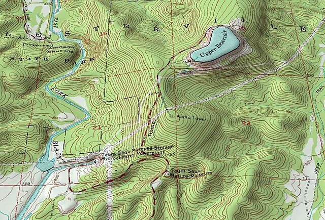
English: An oblique topographic view of the Taum Sauk pumped storage plant. The upper reservoir failed in a catastrophic manner in 2005, destroying part of the neighboring state park. As of 2009 the electrical utility which owns the plant is planning to rebuild the reservoir.
When operational, water from the East Fork Black River is pumped to the reservoir atop of Proffit Mountain at night. During periods of peak daytime demand the hydroelectric plant at the bottom of the mountain can use this to generate over 400MW of power. The water flows through a 7000-foot tunnel connecting the upper reservoir to the power plant. Water for pump-back is stored in a lower reservoir on the river (south of the bounds of this image). Johnson Shut-ins State Park is a short ways upstream from the power plant. For scale, the large numbered red squares (21, 22, etc.) on this topographic map are one square mile (2.6 km²) survey sections. Created by Kbh3rd for Wikipedia with public domain data from the USGS for the 7.5" Johnson Shutins, Missouri, topographic quadrangle (37090E7). This image was created with the 3DEM program. This image was originally uploaded to the English Wikipedia before being uploaded to Wikimedia Commons by the original uploader and copyright holder, Kbh3rd. |
| 날짜 | |
| 출처 | 자작 |
| 저자 | Kbh3rd |
| 카메라 위치 | | 이 지역의 다른 사진을 보기: OpenStreetMap |
|---|
라이선스
- 이용자는 다음의 권리를 갖습니다:
- 공유 및 이용 – 저작물의 복제, 배포, 전시, 공연 및 공중송신
- 재창작 – 저작물의 개작, 수정, 2차적저작물 창작
- 다음과 같은 조건을 따라야 합니다:
- 저작자표시 – 적절한 저작자 표시를 제공하고, 라이센스에 대한 링크를 제공하고, 변경사항이 있는지를 표시해야 합니다. 당신은 합리적인 방식으로 표시할 수 있지만, 어떤 방식으로든 사용권 허가자가 당신 또는 당신의 사용을 지지하는 방식으로 표시할 수 없습니다.
- 동일조건변경허락 – 만약 당신이 이 저작물을 리믹스 또는 변형하거나 이 저작물을 기반으로 제작하는 경우, 당신은 당신의 기여물을 원저작물과 동일하거나 호환 가능한 라이선스에 따라 배포하여야 합니다.

|
GNU 자유 문서 사용 허가서 1.2판 또는 자유 소프트웨어 재단에서 발행한 이후 판의 규정에 따라 본 문서를 복제하거나 개작 및 배포할 수 있습니다. 본 문서에는 변경 불가 부분이 없으며, 앞 표지 구절과 뒷 표지 구절도 없습니다. 본 사용 허가서의 전체 내용은 GNU 자유 문서 사용 허가서 부분에 포함되어 있습니다. |
파일 역사
날짜/시간 링크를 클릭하면 해당 시간의 파일을 볼 수 있습니다.
| 날짜/시간 | 섬네일 | 크기 | 사용자 | 설명 | |
|---|---|---|---|---|---|
| 현재 | 2009년 6월 21일 (일) 14:25 | | 870 × 591 (116 KB) | Kbh3rd | {{Information |Description={{en|1=An oblique topographic view of the Taum Sauk pumped storage plant. The upper reservoir failed in a catastrophic manner in 2005, destroying part of the neighboring [[:en:Johnson Shut |
이 파일을 사용하는 문서
다음 문서 1개가 이 파일을 사용하고 있습니다:
이 파일을 사용하고 있는 모든 위키의 문서 목록
다음 위키에서 이 파일을 사용하고 있습니다:
- de.wikipedia.org에서 이 파일을 사용하고 있는 문서 목록
- en.wikipedia.org에서 이 파일을 사용하고 있는 문서 목록
- es.wikipedia.org에서 이 파일을 사용하고 있는 문서 목록
- fa.wikipedia.org에서 이 파일을 사용하고 있는 문서 목록
- fr.wikipedia.org에서 이 파일을 사용하고 있는 문서 목록
- ms.wikipedia.org에서 이 파일을 사용하고 있는 문서 목록
- no.wikipedia.org에서 이 파일을 사용하고 있는 문서 목록
- sl.wikipedia.org에서 이 파일을 사용하고 있는 문서 목록
- tr.wikipedia.org에서 이 파일을 사용하고 있는 문서 목록