
파일:Vinland Map HiRes.jpg

미리 보기 크기: 800 × 554 픽셀 다른 해상도: 320 × 222 픽셀 | 640 × 443 픽셀 | 1,024 × 709 픽셀 | 1,280 × 886 픽셀 | 2,560 × 1,772 픽셀 | 3,038 × 2,103 픽셀
원본 파일 (3,038 × 2,103 픽셀, 파일 크기: 2.48 MB, MIME 종류: image/jpeg)
|

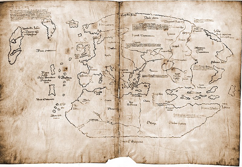
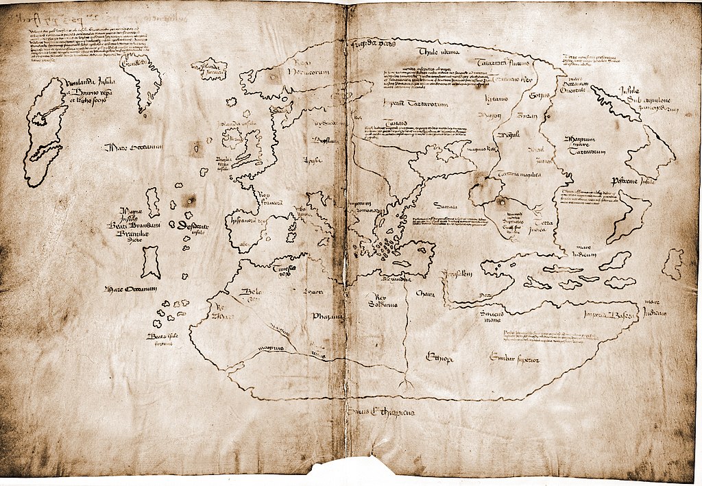
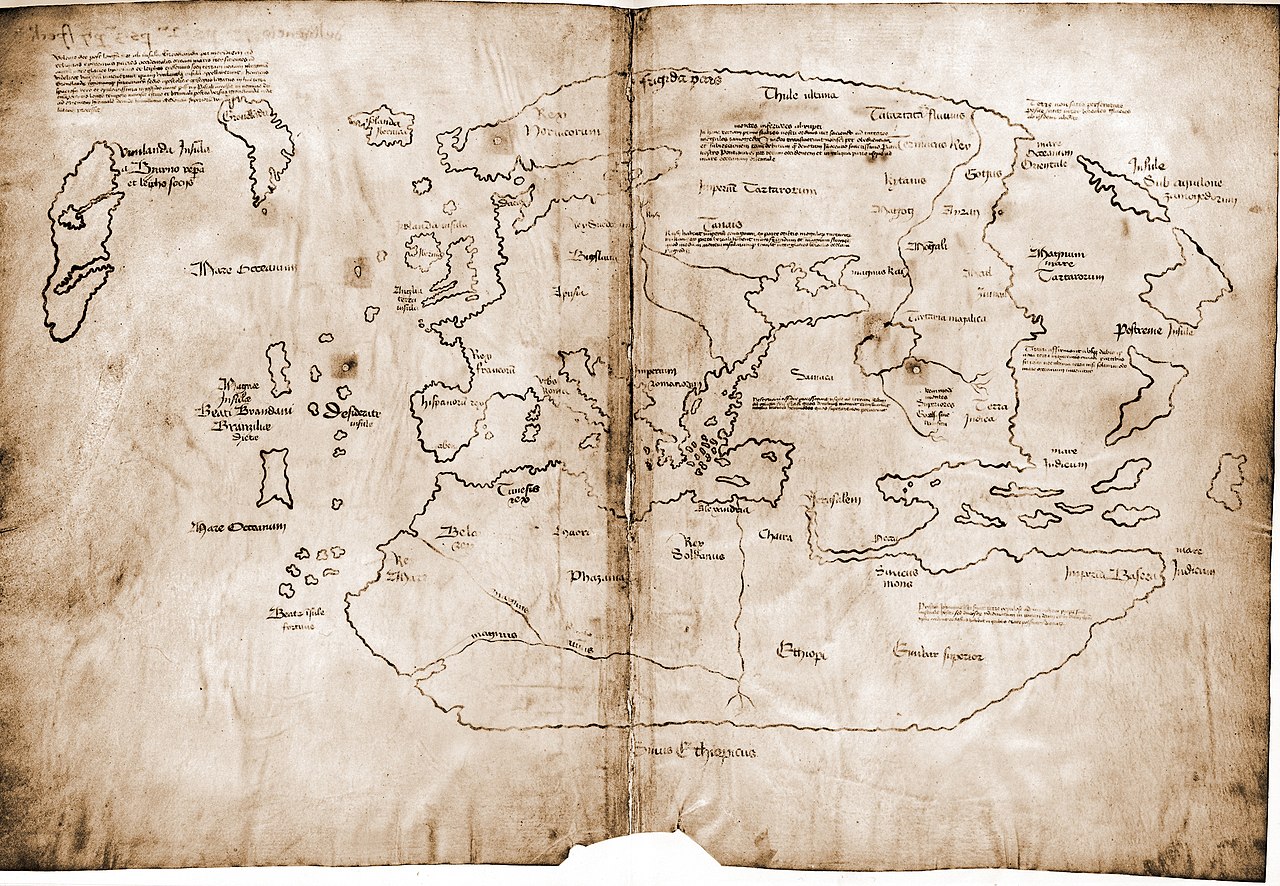
이 이미지는 2007년 12월 31일의 오늘의 이미지로 선정되었습니다. 이미지 설명은 다음과 같습니다. English: The Vinland map, a 15th century world map purportedly based on a 13th century original. If authentic, it is the first known depiction of the North American coastline. 다른 언어들:
Asturianu: Planisferiu del sieglu XV, copiáu d'un orixinal del sieglu XIII, cola primera referencia conocía de la costa Americana septentrional. Nél figura "Vinland" términu viquingu Bahasa Indonesia: Sebuah peta dunia buatan abad ke-15, dibuat ulang berdasarkan peta asli abad ke-13, peta pertama yang diketahui menggambarkan garis pantai Amerika Utara, di wilayah Vinland sekarang. Čeština: Mapa světa z 15. století jako přepis originálu ze 13. století, zachycující údajnou část amerického kontinentu Vinland objevenou možná již před Kolumbem vikingskými mořeplavci. Deutsch: Die Vinland-Karte aus dem 15. Jahrhundert ist die älteste bekannte Karte, die einen Küstenabschnitt Nordamerikas kartiert. Allerdings ist ihre Echtheit zweifelhaft. English: The Vinland map, a 15th century world map purportedly based on a 13th century original. If authentic, it is the first known depiction of the North American coastline. Español: Mapa de Vinlandia, un mapa del siglo XV supuestamente basado en un original del siglo XIII. De ser auténtico, se trataría de la primera representación conocida de la costa norteamericana. Français : Carte du monde au XVe siècle, redessinée à partir d'un original du XIIIe siècle ; première description connue de la côte de l'Amérique du Nord alors appelée Vinland. Italiano: Planisfero del XV secolo, tratto da un originale del XIII secolo, con la prima raffigurazione conosciuta delle coste dell'America settentrionale. Magyar: 15. századi világtérkép, egy 13. századi eredeti másolata, az észak-amerikai partvidék (akkori nevén Vinland) első ismert ábrázolása. Nederlands: 15e eeuwse wereldkaart, overgetekend van een 13e eeuws orgineel, met intekening van Vinland ("Wijnland") Polski: Gdyby była to XV-wieczna mapa świata, przerysowana z XIII-wiecznego oryginału, była by pierwszym znanym opisem wybrzeży Ameryki Północnej zwanej wówczas Vinland. Obecnie jednak jest uznawana za fałszerstwo Português: Um mapa-múndi do século XV, copiado de uma versão do século XIII, com um esboço da costa setentrional dos Estados Unidos. Svenska: Världskarta från 1400-talet, avbildad från ett original från 1300-talet. Det är den första kända avbildningen av Nordamerikas kust. Беларуская: Карта свету 15 ст., копія карты 13 ст. з першым вядомым паказам Вінланду — узбярэжжа Паўночнай Амерыкі. Русский: Карта мира XV века, перерисованная с оригинала XIII века и содержащая первое изображение побережья Северной Америки (обозначенное как Винланд). Српски / srpski: Мапа света из 15. века, прецртана од оригинала из 13. века који је прва позната скица северноамеричке обале, која се тада звала „Винленд“. 日本語: 15世紀の世界地図。当時ヴィンランドと呼ばれた北米の海岸線を、初めて描写したことで知られる13世紀の原画を描き直したもの。 中文: 15世纪时从13世纪原稿复制的世界地图,是首次描绘出北美洲海岸的地图,当时称北美洲为“葡萄地”。 |
파일 설명
| 설명 |
Dimensions: 27.8 by 41.0 centimeters (10.9 by 16.1 inches) English: The Vinland map / chart is purportedly a 15th century Mappa Mundi, redrawn from a 13th century original. Drawn with black ink on animal skin, if authentic the map is the first known depiction of the North American coastline, created before Columbus' 1492 voyage. The upper left caption reads: “By God's will, after a long voyage from the island of Greenland to the south toward the most distant remaining parts of the western ocean sea, sailing southward amidst the ice, the companions Bjarni and Leif riksson discovered a new land, extremely fertile and even having vines, ... which island they named Vinland.” Most scholars and scientists who have studied the map have concluded that it is a fake, probably drawn on old parchment in the 20th century.
Deutsch: Die Vinland Mappe / Karte ist angeblich eine Weltkarte des 15. Jahrhunderts, neu gezeichnet von einem Original aus dem 13. Jahrhundert . Gezeichnet mit schwarzer Tinte auf Tierhaut, wenn sie echt wäre, wäre die Karte die erste bekannte Darstellung der nordamerikanischen Küste, die vor Kolumbus' Reise 1492. Im linken oberen Teil Inschrift: "Mit Gottes Willen, nach einer langen Reise von der Insel Grönland nach Süden durch das Eis segelnd zu den am weitesten entfernten übrigen Teilen des westlichen Ozeans, entdeckten die Gefährten Bjarni und Leif Erikssohn ein neues Land, äußerst fruchtbar und sogar mit Reben, eine Insel, die sie Vinland nannten" Die meisten Gelehrten und Wissenschaftler, die die Karte untersucht haben, kommen zu dem Schluss, dass die Karte eine Fälschung ist, die wahrscheinlich im 20. Jahrhundert auf alten Pergament gezeichnet wurde.
Français : La carte du Vinland est une carte datant peut-être du XVe siècle, et reprenant un original du XIIIe siècle. Tracée à l'encre noire sur du parchemin, cette carte est la première carte connue montrant la côte de L'Amérique du Nord, et est plus ancienne que le voyage de Christophe Colomb (1492). La légende en haut à gauche se lit “Par la volonté de Dieu et après un long voyage depuis l'île du Groenland vers les parts les plus lointaines de la mer océane de l'ouest, naviguant au sud au milieu des glaces, les compagnons Bjarni et Leif Eiriksson découvrirent une nouvelle terre, très fertile et portant de la vigne [...] ils la nommèrent Vinland.” La plupart des études au sujet de cette carte suggèrent qu'elle est truquée, dessinée au 20me siècle sur deux feuilles de parchemin anciennes.
Polski: Uznawana jako XV-wieczna mapa świata, przerysowana z XIII-wiecznego oryginału, gdyby była prawdziwa zawierała by pierwszy znany opis wybrzeży Ameryki Północnej zwanej wówczas Vinland. Obecnie jednak na podstawie analizy składu atramentu jest uznawana za fałszerstwo powstałe po 1923 roku.
Українська: Мапа Вінланду з атласу «Mappa mundi» XV століття, зроблена з оригіналу XIII століття. Зображення нанесені чорною фарбою на шкірі тварини. Автентична карта є першим відомим зображенням північноамериканського узбережжя, що було створене до подорожі Христофора Колумба 1492 року. У верхньому лівому кутку напис: «За Божою волею, після довгого плавання від острова Гренландія на південь до найдальших частин Західного океану моря, плавання на південь серед криги, товариші Б'ярні і Лейф Ерікссон віднайшли нову землю, дуже родючу й багату на виноград... землі названі Вінландом.»
Більшість дослідників і вчених, які вивчали карту, дійшли висновку, що це фальшивка, ймовірно, зроблена на старому пергаменті у XX столітті. |
| 날짜 | |
| 출처 | Yale University, from this website |
| 저자 | Yale University Press |
라이선스
If the map is real, then it is public domain by virtue of its age. In the far more likely possibility of it being fake, it is public domain because it was published without copyright notice before 1977 (even ignoring the question of if the true creator of the map forfeited copyright protection immediately by not openly claiming the work).
|
이 그림은 2차원 저작물에 대한 사진 복제본으로, 원본 저작물은 현재 저작권이 풀려 있는 퍼블릭 도메인 하에 있으며, 구체적인 정보는 아래와 같습니다.
위키미디어 재단에서는 2차원 저작물의 사진 복제본에 대해서 ‘2차원 퍼블릭 도메인의 사진 복제본은 역시 퍼블릭 도메인이라고 생각하며, 또한 이러한 주장은 일반적인 퍼블릭 도메인에 대한 개념으로, 이에 대한 반대는 일반적으로 사용되는 퍼블릭 도메인의 개념 자체를 반대하는 것이다’라고 입장을 밝혔습니다. 자세한 설명은 PD-Art 틀을 사용하는 경우 문서를 참조해주세요.
따라서, 이 사진 복제본은 역시 퍼블릭 도메인으로 간주됩니다. 그림을 사용할 때에는 해당 국가와 지역의 법을 확인해 주시기 바랍니다. 경우에 따라서는 관할 구역의 법에 의해 사용이 제한되어 있을 수 있습니다. 자세한 사항은 PD-Art 틀을 사용하는 경우를 확인해주세요. | ||||
이 저작물은 1929년에서 1977년 사이에 미국에서 출판되었으며, 저작권 표시가 없었기 때문에 미국에서 퍼블릭 도메인입니다. 자세한 내용은 허틀 차트와 공공 예술품 "출판"에 대한 자세한 설명을 참조하시기 바랍니다. 이 저작물은 미국의 저작물(저작자의 사망일 기준)에 대하여 단기 보호 기간 조항이 적용되지 않는 관할 구역에서 여전히 저작권 보호 대상이며, 캐나다(저작자의 사망 이후 50년), 중국 대륙(저작자의 사망 이후 50년, 홍콩·마카오 제외), 독일(저작자의 사망 이후 70년), 멕시코(저작자의 사망 이후 100년), 스위스(저작자의 사망 이후 70년) 및 그 외의 조약이 있는 국가들에 대해 주의할 필요가 있습니다.
|
 |
| 주석 | 이 이미지에는 주석이 있습니다: 공용에서 주석을 보기 |
파일 역사
날짜/시간 링크를 클릭하면 해당 시간의 파일을 볼 수 있습니다.
| 날짜/시간 | 섬네일 | 크기 | 사용자 | 설명 | |
|---|---|---|---|---|---|
| 현재 | 2007년 9월 8일 (토) 06:15 | | 3,038 × 2,103 (2.48 MB) | Jeff Dahl | {{Information |Description=The Vinland map is purportedly a 15th century Mappa Mundi, redrawn from a 13th century original. |Source=Yale University |Date=9-7-07 |Author= |Permission= |other_versions= }} |
이 파일을 사용하는 문서
다음 문서 1개가 이 파일을 사용하고 있습니다:
이 파일을 사용하고 있는 모든 위키의 문서 목록
다음 위키에서 이 파일을 사용하고 있습니다:
- af.wikipedia.org에서 이 파일을 사용하고 있는 문서 목록
- ar.wikipedia.org에서 이 파일을 사용하고 있는 문서 목록
- az.wikipedia.org에서 이 파일을 사용하고 있는 문서 목록
- ba.wikipedia.org에서 이 파일을 사용하고 있는 문서 목록
- be.wikipedia.org에서 이 파일을 사용하고 있는 문서 목록
- bg.wikipedia.org에서 이 파일을 사용하고 있는 문서 목록
- bn.wikipedia.org에서 이 파일을 사용하고 있는 문서 목록
- ca.wikipedia.org에서 이 파일을 사용하고 있는 문서 목록
- cs.wikipedia.org에서 이 파일을 사용하고 있는 문서 목록
- cv.wikipedia.org에서 이 파일을 사용하고 있는 문서 목록
- da.wikipedia.org에서 이 파일을 사용하고 있는 문서 목록
- de.wikipedia.org에서 이 파일을 사용하고 있는 문서 목록
- en.wikipedia.org에서 이 파일을 사용하고 있는 문서 목록
- Vinland Map
- Norse colonization of North America
- October 1965
- Portal:Norway/Selected picture
- Portal:Maps/Selected picture
- Wikipedia:Featured pictures thumbs/08
- Wikipedia:Featured picture candidates/October-2007
- Wikipedia:Featured picture candidates/Vinland Map
- Wikipedia:Wikipedia Signpost/2007-10-22/Features and admins
- Portal:Maps/Selected picture/28
- User talk:Jeff Dahl/Archive 1
- Portal:Geography/Featured picture/2008, week 1
- Wikipedia:Picture of the day/February 2008
- Template:POTD/2008-02-26
- Portal:Norway/Selected picture/21
- User talk:Jeff Dahl/Archive 3
- Wikipedia:Featured pictures/Diagrams, drawings, and maps/Maps
- Wikipedia:WikiProject Arctic
- Wikipedia:Wikipedia Signpost/2007-10-22/SPV
- Portal:Geography/Featured picture archive/2008
- Exploration of North America
- Talk:Norton Internet Security/Archive 1
- User:ArjunChikkappa/Norse colonization of North America
- Wikipedia:Wikipedia Signpost/Single/2007-10-22
이 파일의 더 많은 사용 내역을 봅니다.