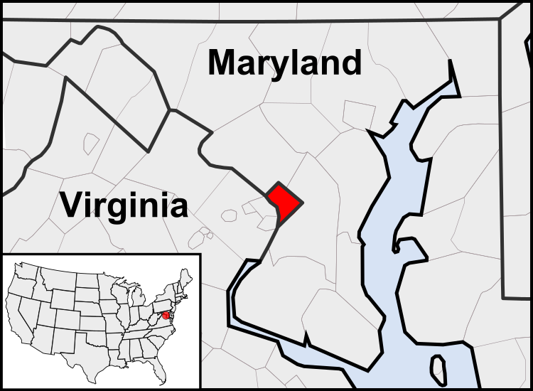
파일:Washington, D.C. locator map.svg

SVG 파일의 PNG 형식의 미리보기 크기: 750 × 550 픽셀. 다른 해상도: 320 × 235 픽셀 | 640 × 469 픽셀 | 1,024 × 751 픽셀 | 1,280 × 939 픽셀 | 2,560 × 1,877 픽셀
원본 파일 (SVG 파일, 실제 크기 750 × 550 픽셀, 파일 크기: 160 KB)
파일 역사
날짜/시간 링크를 클릭하면 해당 시간의 파일을 볼 수 있습니다.
| 날짜/시간 | 섬네일 | 크기 | 사용자 | 설명 | |
|---|---|---|---|---|---|
| 현재 | 2011년 7월 23일 (토) 12:23 |  | 750 × 550 (160 KB) | Patrickneil | Reverted to version as of 03:04, 23 July 2011 |
| 2011년 7월 23일 (토) 12:21 |  | 750 × 550 (161 KB) | Patrickneil | Reverted to version as of 03:14, 23 July 2011 | |
| 2011년 7월 23일 (토) 12:20 |  | 750 × 550 (161 KB) | Patrickneil | frame | |
| 2011년 7월 23일 (토) 12:14 |  | 750 × 550 (161 KB) | Patrickneil | thicker frame | |
| 2011년 7월 23일 (토) 12:04 |  | 750 × 550 (160 KB) | Patrickneil | straightening Maryland and Delaware borders | |
| 2010년 8월 15일 (일) 11:09 |  | 750 × 550 (202 KB) | Patrickneil | Delaware River again | |
| 2010년 8월 15일 (일) 10:51 |  | 750 × 550 (274 KB) | Patrickneil | Delaware River border | |
| 2010년 8월 15일 (일) 10:42 |  | 750 × 550 (273 KB) | Patrickneil | forgot border on Smith Island | |
| 2010년 8월 15일 (일) 10:34 |  | 750 × 550 (273 KB) | Patrickneil | county borders below state | |
| 2010년 8월 15일 (일) 10:32 |  | 750 × 550 (274 KB) | Patrickneil | changes by request |
이 파일을 사용하는 문서
다음 문서 1개가 이 파일을 사용하고 있습니다:
이 파일을 사용하고 있는 모든 위키의 문서 목록
다음 위키에서 이 파일을 사용하고 있습니다:
- af.wikipedia.org에서 이 파일을 사용하고 있는 문서 목록
- an.wikipedia.org에서 이 파일을 사용하고 있는 문서 목록
- ar.wikipedia.org에서 이 파일을 사용하고 있는 문서 목록
- arz.wikipedia.org에서 이 파일을 사용하고 있는 문서 목록
- as.wikipedia.org에서 이 파일을 사용하고 있는 문서 목록
- azb.wikipedia.org에서 이 파일을 사용하고 있는 문서 목록
- bh.wikipedia.org에서 이 파일을 사용하고 있는 문서 목록
- bs.wikipedia.org에서 이 파일을 사용하고 있는 문서 목록
- ceb.wikipedia.org에서 이 파일을 사용하고 있는 문서 목록
- ckb.wikipedia.org에서 이 파일을 사용하고 있는 문서 목록
- en.wikipedia.org에서 이 파일을 사용하고 있는 문서 목록
- en.wikinews.org에서 이 파일을 사용하고 있는 문서 목록
- es.wikipedia.org에서 이 파일을 사용하고 있는 문서 목록
- es.wiktionary.org에서 이 파일을 사용하고 있는 문서 목록
- et.wikipedia.org에서 이 파일을 사용하고 있는 문서 목록
- fr.wikipedia.org에서 이 파일을 사용하고 있는 문서 목록
- fr.wiktionary.org에서 이 파일을 사용하고 있는 문서 목록
- fy.wikipedia.org에서 이 파일을 사용하고 있는 문서 목록
- gv.wikipedia.org에서 이 파일을 사용하고 있는 문서 목록
- hu.wikipedia.org에서 이 파일을 사용하고 있는 문서 목록
- ia.wikipedia.org에서 이 파일을 사용하고 있는 문서 목록
- id.wikipedia.org에서 이 파일을 사용하고 있는 문서 목록
- ilo.wikipedia.org에서 이 파일을 사용하고 있는 문서 목록
- incubator.wikimedia.org에서 이 파일을 사용하고 있는 문서 목록
- it.wikipedia.org에서 이 파일을 사용하고 있는 문서 목록
- jam.wikipedia.org에서 이 파일을 사용하고 있는 문서 목록
- ja.wikipedia.org에서 이 파일을 사용하고 있는 문서 목록
- jbo.wikipedia.org에서 이 파일을 사용하고 있는 문서 목록
- lb.wikipedia.org에서 이 파일을 사용하고 있는 문서 목록
- lfn.wikipedia.org에서 이 파일을 사용하고 있는 문서 목록
- ln.wikipedia.org에서 이 파일을 사용하고 있는 문서 목록
- mi.wikipedia.org에서 이 파일을 사용하고 있는 문서 목록
- mr.wikipedia.org에서 이 파일을 사용하고 있는 문서 목록
이 파일의 더 많은 사용 내역을 봅니다.
