
파일:Yazoo River control structure.jpg

미리 보기 크기: 800 × 533 픽셀 다른 해상도: 320 × 213 픽셀 | 640 × 427 픽셀 | 1,024 × 683 픽셀 | 1,500 × 1,000 픽셀
원본 파일 (1,500 × 1,000 픽셀, 파일 크기: 345 KB, MIME 종류: image/jpeg)
| 설명 |
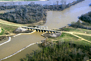
English: One of many control structures used to control flooding and the flow of water in the low-lying Yazoo River Basin in Mississippi, USA. |
|||
| 장소 | Yazoo River Basin, Mississippi, USA | |||
| 날짜 | not specified or unknown | |||
| 출처 |
U.S. Army Corps of Engineers Digital Visual Library Image page Image description page Digital Visual Library home page |
|||
| 저자 | Alfred Dulaney, U.S. Army Corps of Engineers | |||
| 저작권 (이 파일을 인용하기) |
|
파일 역사
날짜/시간 링크를 클릭하면 해당 시간의 파일을 볼 수 있습니다.
| 날짜/시간 | 섬네일 | 크기 | 사용자 | 설명 | |
|---|---|---|---|---|---|
| 현재 | 2007년 4월 8일 (일) 01:48 | | 1,500 × 1,000 (345 KB) | DanMS | {{Information | Description = {{en|One of many control structures used to control flooding and the flow of water in the low-lying Yazoo River Basin in Mississippi, USA.}} | Source = U.S. Army Corps of Engineers Digital Visual Library<br />[http |
이 파일을 사용하는 문서
다음 문서 1개가 이 파일을 사용하고 있습니다:
이 파일을 사용하고 있는 모든 위키의 문서 목록
다음 위키에서 이 파일을 사용하고 있습니다:
- ar.wikipedia.org에서 이 파일을 사용하고 있는 문서 목록
- bg.wikipedia.org에서 이 파일을 사용하고 있는 문서 목록
- da.wikipedia.org에서 이 파일을 사용하고 있는 문서 목록
- en.wikipedia.org에서 이 파일을 사용하고 있는 문서 목록
- es.wikipedia.org에서 이 파일을 사용하고 있는 문서 목록
- fr.wikipedia.org에서 이 파일을 사용하고 있는 문서 목록
- fy.wikipedia.org에서 이 파일을 사용하고 있는 문서 목록