
파일:Myanmar civil war.svg

SVG 파일의 PNG 형식의 미리보기 크기: 367 × 599 픽셀. 다른 해상도: 147 × 240 픽셀 | 294 × 480 픽셀 | 471 × 768 픽셀 | 628 × 1,024 픽셀 | 1,255 × 2,048 픽셀 | 1,228 × 2,003 픽셀
원본 파일 (SVG 파일, 실제 크기 1,228 × 2,003 픽셀, 파일 크기: 1.3 MB)

|
이 파일은 최신 정보를 받아서 업데이트될 가능성이 있습니다. 새로운 업데이트가 반영되는 것 없이, 특정 판의 파일을 사용한 경우에는, 필요한 판을 다른 파일로서 업로드해주세요. |
파일 설명
| 설명 |
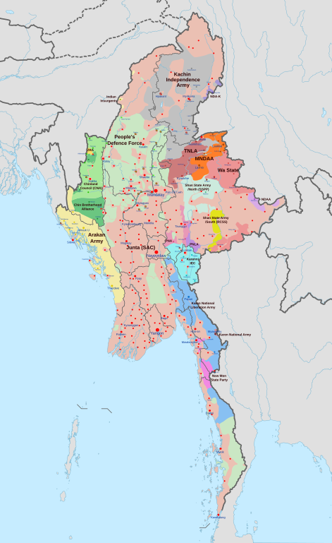
English: A map of the Myanmar civil war (2021–present)
|
| 날짜 | |
| 출처 | 자작 derivate of Myanmar adm location map.svg by NordNordWest. Citing @ThomasVLinge |
| 저자 | Ecrusized |
| 다른 버전 |
|

이 파일은 SVG <switch> 요소를 사용하여 번역되었습니다. 모든 번역들은 같은 파일에 저장됩니다! 여기를 참고하세요.
번역이 완료된 당신의 언어에서 이 파일을 이용할 때에는 언어 코드와 To translate the text into your language, you can use the SVG Translate tool. Alternatively, you can download the file to your computer, add your translations using whatever software you're familiar with, and re-upload it with the same name. You will find help in Graphics Lab if you're not sure how to do this. |
라이선스
나는 아래 작품의 저작권자로서, 이 저작물을 다음과 같은 라이선스로 배포합니다:
| 이 파일은 크리에이티브 커먼즈 CC0 1.0 보편적 퍼블릭 도메인 귀속에 따라 이용할 수 있습니다. | |
| 저작물에 본 권리증서를 첨부한 자는 법률에서 허용하는 범위 내에서 저작인접권 및 관련된 모든 권리들을 포함하여 저작권법에 따라 전 세계적으로 해당 저작물에 대해 자신이 갖는 일체의 권리를 포기함으로써 저작물을 퍼블릭 도메인으로 양도하였습니다. 저작권자의 허락을 구하지 않아도 이 저작물을 상업적인 목적을 포함하여 모든 목적으로 복제, 수정·변경, 배포, 공연·실연할 수 있습니다.
|
파일 역사
날짜/시간 링크를 클릭하면 해당 시간의 파일을 볼 수 있습니다.
| 날짜/시간 | 섬네일 | 크기 | 사용자 | 설명 | |
|---|---|---|---|---|---|
| 현재 | 2024년 4월 30일 (화) 19:32 | | 1,228 × 2,003 (1.3 MB) | MrBLOCKiron | Continuation of yesterdays edit, check april 29 discussion. |
| 2024년 4월 30일 (화) 01:45 |  | 1,228 × 2,003 (1.3 MB) | MrBLOCKiron | Update, check talk page for notes and sources | |
| 2024년 4월 18일 (목) 03:46 |  | 1,228 × 2,003 (1.29 MB) | EmeraldRange | Updating Myawaddy area to reflect territory taken - Shwekoko to the north and Thinganyinaung to the west as per Talk on en:Myanmar civil war (2021-present) | |
| 2024년 4월 12일 (금) 12:01 |  | 1,228 × 2,003 (1.3 MB) | PequodOnStationAtLZ | updated to reflect rebel capture of myawaddy | |
| 2024년 4월 5일 (금) 05:52 |  | 1,228 × 2,003 (1.3 MB) | EmeraldRange | Updated based on Timelines , sources and new map from van Linge; see File Talk/Discusion for sources | |
| 2024년 3월 24일 (일) 00:35 |  | 1,228 × 2,003 (1.29 MB) | TheWasalpha | Capture of Rathedaung last week by AA, removed a misplaced dot in Bangladesh | |
| 2024년 3월 18일 (월) 01:47 |  | 1,228 × 2,003 (1.29 MB) | EmeraldRange | Updated with other items to March 17, see File Talk/Discussion | |
| 2024년 3월 16일 (토) 15:32 |  | 1,228 × 2,003 (1.27 MB) | Hoben7599 | See discussion for source links | |
| 2024년 2월 22일 (목) 00:12 |  | 1,228 × 2,003 (1.27 MB) | EmeraldRange | Updated to include Myebon capture, Mabein capture and AA territory updates based on source from Talk:Myanmar civil war. (See discussion for source links) | |
| 2024년 2월 16일 (금) 12:25 |  | 1,228 × 2,003 (1.27 MB) | EmeraldRange | fixed wrong layering for Karenni |
이 파일을 사용하는 문서
다음 문서 1개가 이 파일을 사용하고 있습니다:
이 파일을 사용하고 있는 모든 위키의 문서 목록
다음 위키에서 이 파일을 사용하고 있습니다:
- ar.wikipedia.org에서 이 파일을 사용하고 있는 문서 목록
- en.wikipedia.org에서 이 파일을 사용하고 있는 문서 목록
- es.wikipedia.org에서 이 파일을 사용하고 있는 문서 목록
- et.wikipedia.org에서 이 파일을 사용하고 있는 문서 목록
- fa.wikipedia.org에서 이 파일을 사용하고 있는 문서 목록
- fr.wikipedia.org에서 이 파일을 사용하고 있는 문서 목록
- hu.wikipedia.org에서 이 파일을 사용하고 있는 문서 목록
- it.wikipedia.org에서 이 파일을 사용하고 있는 문서 목록
- ja.wikipedia.org에서 이 파일을 사용하고 있는 문서 목록
- ms.wikipedia.org에서 이 파일을 사용하고 있는 문서 목록
- my.wikipedia.org에서 이 파일을 사용하고 있는 문서 목록
- pt.wikipedia.org에서 이 파일을 사용하고 있는 문서 목록
- ru.wikipedia.org에서 이 파일을 사용하고 있는 문서 목록
- th.wikipedia.org에서 이 파일을 사용하고 있는 문서 목록
- uk.wikipedia.org에서 이 파일을 사용하고 있는 문서 목록
- zh.wikipedia.org에서 이 파일을 사용하고 있는 문서 목록